It’s said that beauty is in the eye of the beholder and at Yallambie Homestead, with its tumble down verandahs, unpainted corridors and chaotic ongoing renovation that makes for a lot of beholding. Long before the spate of “reality” renovation shows popularized it as entertainment, swinging a hammer had become somewhat of a weekend entertainment in this house, a leisure time activity it could be said that’s more usually reserved in other places for men wearing arrows on their jackets and working in a chain gang.
Sometimes it feels to me like it’s been hard to tell the difference.
I can’t say we didn’t enter into this with our eyes wide open. When the property was up for sale in 1993 a real estate column summed up the broad reality of the project, warning that, “Once imagination ceases and practicality takes over, Yallambie House looks like a lot of work (and money) for potential buyers.” (Heidelberger, p23, 16 December, 1993). It’s been that way ever since and while it may not be everyone’s cup of tea, it has had its moments. Just look back on some of these posts written on a monthly basis over the last five or six years. Then again, not everyone might necessarily agree with our obsession with the Victorian aesthetic. Beauty is in the eye of the beholder after all.
The cast iron, claw foot bath photographed in 1993. A bit rustier but not much changed today.
Back in 1993 I remember a property agent speaking derisively of the old claw foot bath tub present in one of the bathrooms at Yallambie, declaring that it would have to be one of the first things to go in any renovation, but it was precisely for this and for other original elements in the house that, flying in the face of all common sense, our interest was piqued.
The rest as they say is history.
To illustrate how things rely so much on your matter of perspective, in 1993 it was a renovated bathroom upstairs that received special praise by an agent in a newspaper article:
“A fully refurbished tiled spa bathroom hints at the standard of luxury that might fittingly go with ownership of Yallambie Homestead.” (The Age, p39, 11 December, 1993)
But you know what? Luxury has never been my thing. Given the choice between the old fashioned and modern, the impractical or the practical, the impractical wins out every time.
And that’s been our approach to life ever since. So when the time came for renovating a bathroom here, it was pretty clear in which direction we would soon be heading.
Freud said that soap is the yardstick of civilization and while the average house in Victorian times didn’t usually include a dedicated bathroom, it could be said at Yallambie civilization came by pretty late in the day. The first plumbed bathroom wasn’t introduced until Annie Murdoch’s 1926 renovations, which I guess explains why most people in those days reportedly only ever had a bath on Sunday, and ponged for the rest of the week.
Currently there are three bathrooms at Yallambie, the previously mentioned spa and the claw foot bath, upstairs and downstairs respectively, but it was the bathroom attached to the old servants’ quarters that properly gave us the horrors. After a quarter century living with it, the time had finally come for it to go and meet its maker.
“…poo brown tiling and cheap acrylic cabinetry” of the bathroom prior to being removed.
Or in my mind, I was ready to send it to that other place.
Out came that hammer.
By the look of it, I’m guessing the previous poo brown tiling and cheap acrylic cabinetry had been put in more than 50 years ago, with little else of note preceding it. It was a joy to knock it down. For its size, the bathroom has often been thought of as the most expensive room in a house to renovate and while wrecking it is the easy part, putting it back together is another story. Even with the best laid plans, inevitably there are complications.
The old tiling in this room had been applied to tile sheeting battened onto the wall which in effect lost us several inches across the width of what was already a particularly small room. That didn’t suit us at all so off it had to come. As I levered it from the wall I peered at the back of the sheet as it came away in my hands. “A”, “S”, “B” I began to read before downing tools and jumping out of the window which had been left open to clear the lingering dust. A phone call later to the Asbestos removal professionals and the first unforeseen problem was solved and the first unforeseen expense added to the ledger.
The new tub in place, July, 2020.
Given that the servants’ rooms were a post 1910 addition to the house we chose an Edwardian inspired look for the room including subway tiling and chrome fittings. The fittings were mostly purchased new from a popular internet auction site while the tile design was made up as we went along with tiles sourced from at least five different tile suppliers. All the work was done by yours truly, excepting of course the electrics and the plumbing and while the tiling alone took me a long, long time I find such processes almost therapeutic and in a creative way, not that far removed from my professional life as a commercial artist.
The tiling takes shape, August, 2020.The therapeutic process of laying tiles with a furry apprentice under your feet, July, 2020.
The old ceiling proved to be in pretty poor condition and wet plastering over your head has never been my idea of fun so after some discussion we decided instead to replace it with Baltic pine lining boards, after first considering pressed metal. Either would have been appropriate for the Edwardian look we intended, but the Baltic boards won out as they continued through with a theme already established in the nearby kitchen area. The cast iron vent introduced into the ceiling in front of an electric exhaust fan was found locally a couple of years ago at the formerly annual, pre-pandemic, Lower Plenty Primary School car boot sale. Don’t ask me how such a thing ended up for sale there.
“The usual colour was a shade of cream, buff or light brown for the walls with a buff ceiling. From the 1880s, sanitary wallpapers were made which could be used in bathrooms. As a rule, no cornices were used. The only real concession to decoration was a stained-glass window, which served a dual function by retaining privacy for the occupant of the bathroom while providing a degree of natural light.” (The Bathroom, Victorian Splendour, Suzanne Forge, Oxford Press, 1981)
A dry run of the mosaic floor tiles used to work out the pattern, December, 2020.
Painted surfaces were kept deliberately simple and we did away with architraves altogether, tiling mud cap tiles over any edges and attaching other tiles onto a surface level adjacent to the plaster, in effect leaving no edges for cleaning purposes. The level of the floor was dropped so that the surface came out on the same level as the timber floor in the passage way outside and the tiling sloped towards a single drain point in the floor. We developed a floor pattern design using small hexagonal and square mosaic tiles which, given the small area covered, was of necessity kept simple.
“…done and dusted,” February, 2021.
The Edwardians often favoured lead light glass in bathroom windows and with this in mind I had already previously repurposed the old Yallambie front door lead light into the window of this bathroom. The bathroom door itself was pretty decrepit and after measuring up I noticed that an old leadlight door removed at another time from above the front balcony at the other end of the house would fit, after using a little amateur carpentry. The only concern might be the use of transparent rather than translucent glass in the leadlight of this door, but in a choice between privacy and aesthetics, it was the aesthetics that of course carried the day.
“Today must be bath Sunday.” The finished project, February, 2021.
So here is the result. My wife is happy with it but happier still that it’s finally done and dusted and we can at last move on to other projects. She handed me a broad brush the other day and reminded me we have the whole outside of a house to paint now.
Perhaps you remember it as the place you called at on your way home from school, your pocket money burning a hole for a 5 cent, white wax paper bag of mixed lollies. Five cents could buy you a lot of tooth decay in those days. Or maybe you remember it as a place to meet the gang, a place where you could fool around with Coca Cola yo-yos on strings, trade Scanlens football cards or punish the sides of the old pin ball machine inside.
It was the witness to the springtide of our lives.
I’m talking of course of that pillar of small retail society, the ubiquitous Aussie milk bar. Now largely lost to history, as a concept it has now all but vanished, like the Polly Waffle chocolate bars it sold and those frozen Sunny Boy triangular ices – free tokens printed oh, so rarely, on the inside wrapping.
An ode to the milk bars of memory.
An artist’s impression of the planned Yallambie shopping precinct, c1967. Jennings’ Stage 1 subdivision originally called for this to be built on the corner of Yallambie Rd and Corandirk Place with a school next door. In the end a much smaller shop was built further along on the other side of Yallambie Rd while the school went further north, past the Allima Ave intersection. (From a contemporary real estate brochure).
The milk bar sprang from the old corner shop tradition of a local store prepared to sell just about anything, a Ronnie Barker world of “Open All Hours” but with a uniquely Australian twist on the theme. New emigrants into Australia from Europe after the Second War mixed the idea of the corner shop with an American tradition of soda bars but instead of lemonade sodas, the home grown milk bar sold ice cream milk shakes. It also sold ice cream in cones, lemonade in bottles, hot meat pies, sometimes newspapers (in both the morning AND the afternoon), fags and even the occasional, dangerously addictive, non-prescription pain killer. You see the milk bar would sell you just about anything in a convenience line. It even sold milk, which in case you don’t remember, in those days came in pint sized glass bottles with the cream at the top of the bottle sealed up tight with silver foil.
Lower Plenty shopping strip, c1960. Note the milk bar just beyond the pair of telephone boxes. The Ampol petrol station in the distance has in recent times been converted into a large scale supermarket complex.From the “Yallambie News”, a local newsletter, December, 1972.The Yallambie milk bar already styling itself as a “supermarket” and under “new management” in 1973. (Source: Yallambie News, March, 1973)
Although coming late onto the scene, Yallambie too had its own milk bar. Responding to community demands for a local shop, the developer AV Jennings reserved a block of land for a shop, opposite the site of a planned kindergarten on the corner of Yallambie Rd and Binowee Ave. Opening around 1971, an artist’s rendering from four years earlier shows a building on a grander scale than the one finally completed. By 1973 the “milk bar” was already styling itself as a “supermarket”, going head to head with the next closest shopping precinct, the Lower Plenty strip in Main Rd.
Maunder’s Food Master supermarket at Lower Plenty in the 1970s.From the “Yallambie News”, a local newsletter, March, 1973.The Yallambie shop, Febrruary, 2020.Asian style groceries for sale at Yallambie, February, 2020.The intersection of Jindalee Ave and Yallambie Rd, February, 2020.
This was an era when supermarkets closed at Noon on Saturday so the original concept at Yallambie was for a shop that would operate as a defacto general store but stay open at other times as a milk bar. It worked for a time but the rise of petrol stations operating as convenience stores eventually saw a change in the playing field and in more recent times, the age of digital trading has shifted it again. Anything that you might previously have bought at a milk bar you can now order online from Uber Eats or purchase at the local petrol station. The station in Lower Plenty Rd, Yallambie does all this while the presence of a well-known hamburger franchise next door serves that other traditional function of the milk bar, that of social venue. The fact that you will probably need a car to get to either of them is apparently of small consideration.
Over the last 50 years, the Yallambie shop has moved from milk bar to grocery store, from department store to pizza shop and finally to its latest adaption – an Asian grocer, a reflection perhaps on the changing face of a multicultural society.
You might think this is all a new trend but it’s interesting to reflect for a moment in these pages so often devoted to historical matters, that Chinese herbalists were a feature of Melbourne dating from the goldfields era while Afghan or Indian hawkers were once a common sight in outback Australia. On up country properties like Thomas Wragge’s Tulla in the Riverina, the dignified, bearded and turbaned travellers were sometimes the only way that country people could secure the latest in 19th century consumer society. Their wagons were specially designed with shelves and drawers with sides that could be lowered to display dress material, trousers, hats and shirts, patent medicines, essences, pins and all manner of wares. At Tulla the hawker arrived in the shearing season and set up shop just outside the Home Paddock, not so close to intrude on the homestead but close enough to be reached by foot. As Betty Lush, ne Wragge recalled, remembering her childhood and quoted in Calder’s ‘Classing the Wool and Counting the Bales’:
“At some time during the shearing period the Afghan hawkers would appear with their horse and cart. They were a sort of travelling store and were no doubt a useful institution for the shearers in those days of ‘humping your bluey’ and the nearest store 15 miles away. They always fascinated me. Not only for the variety of things that they stocked but they were colourful people with turbans. They were often quite generous too and many a time I came away from a visit to their cart with a paper cone of boiled sweets…”
A sort of veritable milk bar on wheels.
An “Afghan” hawker and his wagon. “At Tulla the hawker arrived in the shearing season and set up shop just outside the Home Paddock”. (Source: The Australian Sikh Heritage Council)
As an Asian grocery store, the “Yallambie Food Mart/Asian Groceries/Dollar Shop Supermarket” as it styles itself has a lot to live up to but, as it turns out, it is a remarkably well stocked institution for an emporium of this kind located in a suburban back street.
And yes, you can still buy your milk there.
Paul Keating famously described this as the “Asian Century” and has long insisted that we are part of it, in spite of a few claims to the contrary both here and abroad. There’s no escaping the fact that Australia is nearer Asia than it is to either of its previous two greatest spheres of influence, the United Kingdom and United States, neither of which seem to be particularly united just now. I’m afraid a bit of Xenophobia is an all too common part of the human condition, but have you noticed lately the results of unsubstantiated fears of COVID-19 coronavirus? In the heart of the Chinese community down Whitehorse Rd way, face masks have become the latest in fashion accessories and you could shoot a cannon down the middle of the street without fear of hitting anyone. Newspapers have reported that Asian restaurants across town are half empty half the time and at hours of the day when they should be the best part full. Already it has been reported that the iconic Shark Fin House in Little Bourke St, Melbourne, has closed its doors after an 80% drop in customer numbers. I ask you, whatever happened to the spirit of the Blitz?
Locally, there are Chinese takeaways near to Yallambie in Lower Plenty, Rosanna and Greensborough, so let’s pause for a moment and give them a thought.
The Blue Hills Haberdasher, 1967. (Source: National Archives of Australia)
Yow Sing near the corner of Rosanna and Lower Plenty Roads does a pretty mean, homemade dim sim, the ancient décor of the shop probably unchanged from a time 50 years before when the shop converted from a haberdashery known for some reason as “Blue Hills”. I’m thinking now might be a good time to try a dim sim there again as the building of the North East Link Project will soon separate this forgotten shopping precinct from Yallambie once and for all.
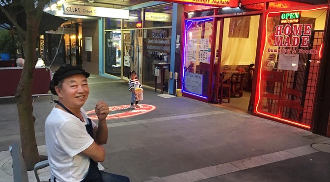
Chef Terry taking a break outside Li’s restaurant on Main Rd, Greensborough, February, 2020.
There are a number of other Chinese eating houses to choose from in easy reach from Yallambie. Several are located in Greensborough but for mine, the best tucker is found at “Li’s Dumplings” in Main Rd, Greensborough. And if you think that’s too far to travel for a feed, please note. You’ll find Li’s dumplings one of the items stocked frozen at the Yallambie shop, so put away those Uber eats.
Deciding to do our bit for the Blitz, we took ourselves off to Li’s Dumpling and Noodle in Greensborough for a meal last Friday night. The décor at Li’s is plain and the seats are hard, but the food and family style atmosphere is terrific. Li’s specialize in dumplings, the skins thin and light but strong enough to hold a variety of yummy fillings intact. They plunge the dumplings in boiling water, stirring vigorously to prevent them sticking then add a cup of cold water half way through the eight minute cooking process to bring out the flavour. I’m told this is the secret of boiling a good dumpling. Or if that doesn’t suit, you can get them fried, the bottoms of the dumplings turning a light golden brown in the process.
The friendly faces of the dumpling house.
We don’t eat out much but when we do it often seems to be to this particular little restaurant that we go. That said, we haven’t got even a part way through the menu yet. Li’s is an establishment that probably does more takeaways than sit down meals and when we went in there with a birthday party once I think they nearly fell down in surprise. There’s an informal atmosphere present here, the sort of feeling you get when you enjoy a home cooked meal though Mum’s Sunday roast was never like this.
On this night we chose chicken and coriander dumplings to start with but there are many others you might choose from, each one rolled, pressed and filled by hand. I’m told that the range of fillings on the menu mirrors what a northern Chinese family might cook at home and reading from the list you’ll find lamb and coriander; chive, vermicelli and egg; fish and calamari; lamb and onion; spicy beef and others just too numerous to mention here.
Sizzling chicken with ginger and onion.
We also ordered sizzling chicken, its sizzle filling the table with steam; honey chicken, the batter light and crisp and without that risk you get of it weighing heavily on an overstocked tum; and a beef fried noodles which I think would give the best fried noodles of my life a run for its money. That was a noodles I remember buying from a Chinese cook serving from a caravan window on an island in the Pacific years ago, a bit too far away now to pop out for a takeaway.
So, if you’re hungry and not just for the memory of Polly Waffle, get yourself down to your local shop and if that shop turns out to be a Chinese eating house or a repurposed milk bar, well you’ll be doing your bit for your local community right now. A changing world has made it hard going for the small retailer, the current fears of a global pandemic only compounding the problems for one section of our community. I suspect these problems aren’t going to go away for a little while yet but until they do, keep rattling those chopsticks.
For tens of thousands of years the presence of fire has been a reality check in this, the world’s smallest and outside of the Antarctic, the driest continent on Earth. Indigenous Australians used these ingredients to their advantage in pre-history, regularly burning the countryside to reduce fuel loads and promote game in a practice we now call “firestick farming”. Early European navigators noted the smoke from the decks of their rolling ships and called Australia that “burning country” while remarking at the same time on the “park like” nature of its scenery. But it was no park. It was a carefully crafted mosaic habitat, created by the locals using a system of land management that had been learned and developed by their forebears over generations.
All human activity has the potential to force changes on the natural order and it seems likely that the Indigenous approach gradually modified the Australian landscape by promoting the spread of volatile, Eucalypt forest at the expense of naturally less flammable plants. The overland explorer of south-eastern Australia Thomas Mitchell observed that, “Fire, grass, kangaroos and human inhabitants seem all dependent on each other for existence in Australia. Fire is necessary to burn the grass and form these open forests in which we find the large kangaroos.” In the Pacific Rim, the extinction of giant flightless Moa birds in New Zealand and the whole sale destruction of the Rapa Nui subtropical broadleaf forests of Easter Island shows what can happen when humans get it wrong but generally Australia’s First people lived in a harmonious relationship with the land.
The Australian continent the Indigenous Australians sought to successfully control is a hugely fire prone land and nowhere is this more-so than in its South Eastern corner. A recent report by an independent assessment group (Risk Frontiers) ranked the top 10 fire danger post codes in Australia by risk potential and wouldn’t you know it? They are all located in Victoria. It’s a danger that might not have been fully appreciated by the initial wave of European settlers in the 19th century but with the end of Indigenous land management, the bush was primed for what came next. In terms of the area damaged, the devastating bush fires that consumed much of the Port Phillip District on “Black Thursday”, 6 February, 1851 still stand as the most wide spread of the dozens of major fires that have occurred in the State of Victoria since European settlement. Over five million hectares of country burned and a million sheep were destroyed in 1851, while the comparatively low human death toll of 12 is perhaps only a reflection of the small and dispersed population of the Port Phillip District at that time.
“Fire commenced by the upper Plenty River when bullock-drivers left a smouldering fire behind them. Driven by strong, hot, north winds, it swept through the Plenty and Diamond Creek districts and close to Heidelberg before joining with other fires. Thousands of hectares of grassland were burnt; dozens of homesteads, woolsheds, bridges and shacks were destroyed; crops were lost and thousands of head of stock incinerated. Even though so close to the source of the fire, “Yallambee” escaped.”
(Calder, “Classing the Wool and Counting the Bales”, recording the tale of the 1851, Port Phillip District bush fires.)
The Station Plenty, (Yallambie) view III by Edward La Trobe Bateman 1853-1856. House with lattice-work verandah and garden. (Source: National Gallery of Victoria)Black Thursday, February 6th, 1851 by William Strutt. (Source: State Library Victoria)
As remarked by Calder, John and Robert Bakewell’s Yallambee Park missed most of the destruction wrought by the 1851 fires although it is known that other properties in Heidelberg area were amongst those affected. Fire was an ever present concern in the colonial period and Calder records that a later fire may have been the eventual fate of the Bakewells’ original wooden “Yallambee” farm house although direct evidence of this beyond the anecdotal would appear to be slight.
“It has been claimed that there was a serious fire in 1866 which destroyed the Bakewell house.” (Calder, ibid, p77)
Smoke from the fires added to dust blown up by the winds adds to a weird evening light at Yallambie, November, 2019.
The Plenty River at Yallambie marks the boundary between two fire services, the Country Fire Authority on the Lower Plenty side and the Metropolitan Fire Brigade on the Yallambie side but fires are no observer of official boundaries. On Christmas Eve last year fire trucks raced up Greensborough Rd from here towards a fire in the Plenty Gorge near the Metropolitan Ring Rd while the month before, four fires started overnight in Lower Plenty and Viewbank between Edward Willis Court and Seymour Rd. We could see the lights of the emergency service vehicles from that fire flashing across the valley in the night and wondered what was up. It was confirmation if confirmation had been needed that even here in the suburbs the landscape is not without fire risk.
Fire at Lower Plenty. (Source: Facebook, Herald Sun/Heidelberg Leader)
The deadly Black Saturday Bushfires 10 years ago will never fade from memory and most people living on this side of town probably knew somebody directly affected by the disaster, but as our news services continue to ring this year with the latest stories of the calamitous 2020 bush fires sweeping across the country right at this moment, it is the national scale and the sheer breadth of the disaster that makes this fire season stand alone. Virtually the whole continent is on fire in some part or in some place, burning even as I sit here, typing about it like Nero on his fiddle while Rome burned. You can smell it on the air and see it in the afternoon light. There is no escape.
Photograph released by the Victorian Government Department of Environment, Land, Water and Planning to illustrate how the 2020 bush fires have been creating their own weather systems. (Picture by Dale Appleton)
So what can we do? Australia has just recorded its hottest and driest year on record. Again. Many now believe that it is human-caused global warming that has raised the severity of heat events and the associated dangers of wildfire by speeding up the annual drying of the rural landscape. The southern part of Australia has warmed on average by about 1.5° C since 1950 but try telling the politicians that there are consequences to pulling fossil fuels out of the ground with our opposable thumbs to fuel antiquated carbon emitting power stations and you will likely be met by indifference. Some reports state that the 2019/20 fires have already filled the Australian skies with two thirds of the nation’s annual carbon dioxide emissions and experts are warning that it may take forests more than 100 years to re-absorb what’s been released so far in this season. That’s assuming that in a hundred years we still have forests.
The horizon on fire at Sarsfield near Lakes Entrance in Gippsland, January, 2020. This picture appeared on social media last week after many people identified a demonic face in the flames at right. (Source: David Woiwod on Twitter)
Addressing the British Parliament in July last year on the dangers of man-made climate change, Legendary natural historian and documentary film maker, David Attenborough said that, “Australia is already facing having to deal with some of the most extreme manifestations of climate change.”The sight of Sir David looking out from behind the lens of his camera in the future and saying, “I told you so” ain’t going to help us much but maybe, just maybe it might be the consequences of this season’s fires that will at last spur Australia into some sort of climate action. Sir David has long resisted attempts at politicizing his life’s work but at age 93 he’s going for broke and taking aim at government policies head on:
“We have to convince bankers and big business that, in the end, the long-term future lies in having a healthy planet. And unless you do something about it… you’re going to lose your money.”
So there’s the crux of it. Mention furry animals and trees and you will be met by stony silence from Government circles but talk to them about economics and potential damage to property, the financial sector and the danger to the quintessential Aussie way of life and you just might get some action. In Douglas Adams’ Hitchhiker’s series, the Golgafrinchams adopt the leaf as legal tender, burning down all the forests they find in order to avoid the rampant hyper-inflation of the currency that the presence of too many trees has created. The story was a jest, yes but possibly you know a Golgafrincham. I suspect there may be one wanting to stand as your member come the next election.
Throughout the ages the collective memory of primitive societies has been preserved by what we call “the oral tradition”. It might seem unlikely now in this age of the internet and digital space, but before the invention of the written word, oral tradition was often the only way that human beings were able to preserve the record of generational knowledge outside the superfluous grey matter found between their ears.
We might think we’ve come a long way since but in some ways the power of memory is as important now as it ever was. Oral history, as opposed to oral tradition, is an academic discipline which can be defined by the collection and study of historical information using recording devices and interview techniques, a process which strives to obtain information unavailable by other methods. Publishing these personal histories has never been more popular with desk top publishing and cheap printing making the process relatively easy.
Locally, the Greensborough Historical Society has taken a leaf out of what could be called the oral history book by publishing a couple of recent companion volumes, “As I Recall” and “Do You Recall?” which feature stories drawn from the memories of long-time residents of Greensborough and nearby suburbs. Last week while travelling on the 293 Greensborough bus with my nose buried in the pages of one of these tomes which happened to be opened at a chapter describing the history of the now defunct Diamond Valley Community Hospital, a woman sitting next to me after first apologizing for reading over my shoulder pointed at the page and said, “I was born at that hospital.”
“You and about 10,000 others,” I said, quoting directly from the pages of the book.
What followed then turned into an interesting chat about her memories of the local area before I had to let it go and get off at my stop, leaving her story only half complete. It was a loss in one respect. Given longer I’m guessing I might have turned her story into a post, but in another respect it was a gain as it got me thinking about history and the importance of memory within the spoken framework. As it happens, both GHS volumes contain chapters recording the memories of one Eric Barclay and are complete with his impressions of what it was like growing up in a Post War rural environment on what was colloquially known as the Grace Park Estate, Greensborough. This estate was located more or less on the northern boundaries of Yallambie and at one time was home to a rough and ready, 9-hole golf course. It was an area parts of which remained semi-rural into the last quarter of the 20th century and Eric’s story makes an interesting tale.
Dorothy and Henry Barclay, (Source: Eric Barclay Collection, Greensborough Historical Society picture).
Born in 1938, Eric Barclay was the only child of Henry and Dorothy Barclay who were aged 60 and 40 respectively when their son surprised them by being born. The family owned a small weatherboard cottage on a 10 acre farm in Elder St, Greensborough, south of where Henry St ends at the T intersection. The Barclay property was located about an equidistance from Greensborough, Montmorency, Watsonia and Lower Plenty and could only be accessed along unmade roads and bush tracks. The house, which had been relocated from Collingwood in an earlier era, was without power, sewerage or mains water and although basic in its necessities, it proved to be a happy and healthy childhood environment for young Eric.
Eric Barclay, left, and friend Harry Arrowsmith in the Barclay’s orchard c1944, (Source: Eric Barclay Collection, Greensborough Historical Society picture).
“We were hillbillies. We never ever got the light on until the early 50s…. We were very primitive out there. One thing about it, when we were hungry we had a bit of an orchard. Dad was a good gardener. We had vegetables. We had plenty of chooks, plenty of eggs.” (Eric Barclay, “Do You Recall?” GHS, 2017)
Much of Eric Barclay’s story as related in the two GHS books is devoted to what he called his memories of “The Big Paddock”, (the title of his chapter in “Do You Recall?). The Big Paddock was a 600 acre area roughly bounded in the west by Greensborough Rd, in the north by Nell St, the east by the River where the unmade track that was Elder St petered out, and by Yallambie in the south.
Eric Barclay’s hand drawn map, (not to scale) recording his memories of the paddocks north of Yallambie soon after the Second War, (Source: Greensborough Historical Society).
“It had a wire fence around it and besides briar bushes only had cattle, kangaroos and hares in it… Every year The Big Paddock used to get burnt out. We had no fire brigades in Greensborough in those days. The locals would get out and fight it, my father and Mr Bell and others. Almost every year up to the late 40s our area’s 5 to 10 acre farmlets had a planned burn off and they’d do maybe three places one night, all the men. The women would have a central place where they’d have cups of tea and a few beers later on. We did that until all the tussocks had been cleared off. We’d look forward to it as kids, we’d have a bag each and go round beating out the posts so they didn’t take fire.” (Eric Barclay, “Do You Recall?” GHS, 2017)
Stubley’s Hay and Grain Store, Main Rd, Greensborough, c1950, (Source: Greensborough Historical Society).
Eric’s father, Henry was employed at “Stubley’s”, a produce merchant in Main Rd, Greensborough with ties to a motor garage and service station of the same name. Later Henry found work at Annie Murdoch’s Yallambie, a circumstance that will be of particular interest to readers of this blog. The following words are reproduced here, directly from the pages of the Greensborough Historical Society volume, “Do You Recall?” published by the Society in 2017.
My father Henry Banwell Barclay ended up working at Yallambie House, the mansion. They used to have quite a market garden there, they would have had a couple of hundred acres I reckon. They had river frontage on the Plenty. The driveway of Yallambie House ran through to Lower Plenty Road.
A young Bill Bush pictured in a turnip patch at Yallambie, (screen still from the film “Yallambie”, by Peter Bassett-Smith).
Going through the paddocks I’d take Dad over his lunch and a bottle of cold tea. Dad worked down there on the river flats. They had vegetables and fruit trees. It was pretty substantial. Old Joe worked there as well as Dad who was 60 when I was born in Whittlesea in 1938.
The people that had Yallambie, the elderly lady was Mrs Murdoch. She was the owner, the matriarch. Her daughter married a Mr Bush. They were lovely people. They had two children, Elizabeth, about my age, and Billy who was a lot younger. I can remember Elizabeth going to Ivanhoe Grammar.
A 1950 Daimler Sports Special at Yallambie, (screen still from the film “Yallambie”, by Peter Bassett-Smith).
They had two Daimler cars and one day Mr Bush said “Now, young Eric I’d like to give you a bit of pocket money.” I used to wash the two Daimlers once a fortnight and get three bob… three shillings, which was good. We didn’t have a lot of money. My father had spent a lot on his children (from his first marriage) in the earlier days setting them up. I would have been about 11 at the time. He was 71 and still working over there.
The tennis court at Yallambie, c1955, (screen still from the film “Yallambie”, by Peter Bassett-Smith).
They had an asphalt tennis court there and a year or so later Mrs Bush said “Eric, if you’d like to bring some of your friends over you can play tennis.” So Leslie Dunstan, Donny Bell, Robert Collins and myself would go over there and sweep the leaves off and mark the lines and play. There were elm trees and a big verandah out the back and Mrs Bush would come out and she’d say “Righto boys!” She’d have a table set up on the verandah and we’d have lemonade and butterfly cakes and that. They were terrific.
Each year around Melbourne Cup time they’d put Dad and Mum and myself in the Cup sweep and I’d have to go across Melbourne Cup morning and see what horses we had.
There was a manager’s house there, the cookhouse, the whole lot. In the early days the manager was a Mr Gardiner. The cook was Nellie.
Eric’s story continues with his memories of the Plenty River, the riding school at Woodside, (Casa Maria) and Wragge’s Anglican Church of the Holy Spirit.
Swimming Pool in the Plenty River at Greensborough, c1952, (Source: Greensborough Historical Society).
Us kids learnt to swim in the Plenty River, you’d get holes 20 foot deep. There were platypus and water rats. It was a beautiful stream. When I was a bit older Leslie Dunstone, Donny Bell and myself used to fish it from one end to the other, nearly down to the junction with the Yarra River. That’s a long walk. We’d take hurricane lamps and the dogs with us, a tin of baked beans and a bit of bread.
“Woodside”, home of the Nancy Hosack riding school, later renamed “Casa Maria”, (Source: Pictures Collection, State Library of Victoria).
Along Yallambie Road, which was a gravel road, on the left was Bellamy’s. They had a poultry farm, there were very few houses. You went right along and there was a gate. You’d open the gate and keep going and right down the end of Yallambie Road was Nancy Hosack’s riding school. She had a nice home and the riding school and the stables and so forth. Nancy used to compete in a lot of the gymkhanas and Benny Weir, who lived in Greensborough off Alexandra Street down near the river, was probably one of her greatest competitors in them.
Army cadets at Watsonia (Yallambie) military camp, 1944,, (Source: Australian War Memorial).
Past the gate, on the south side of Yallambie Road, going west, was the army camp land. Years later they brought all the people in from Camp Pell, which was like a Housing Commission kind of setup in Royal Park. That’s when all our chooks started to get stolen and so forth. They brought them out to the army camp for housing up at the top end of the camp in Yallambie Road.
The Church of the Holy Spirit, Yallambie, c1955, (Source: Jean Luxford Collection).Anderson’s Mill on the Plenty by George Alexander Gilbert, from the “Bakewell Collection of drawings by G A Gilbert”. (Source: Pictures Collection, State Library of Victoria)
Where the petrol station is now, there used to be a church there. It was a little brick Church of England church. I think they used to have a service there about once a week. A lot of people wouldn’t know that had been there.
Benny Weir’s swimming hole was probably one of my favourite spots on the Plenty. They had a rope hanging over the river and kids would go swimming there.
In about 1950 Eric’s father began selling off parts of their 10 acre farm. Australia’s leading Greyhound trainer, Stan Cleverly bought half and built the substantial brick home that stands today on a double block at the top of the rise in Elder St at the Henry St intersection. Stan installed a straight greyhound training track alongside his home where he trained from 50 to a 100 greyhounds at a time, although in the words of Eric, “Later on, it paid him more to get dogs beaten. He got outed for a year.” Eventually, Eric sold the last 3 ½ acres of the Barclay farm and moved to Macleod in 1966. His family’s presence is remembered in the area in the name of “Barclay Park”, a small reserve in Plenty Lane, Greensborough.
The importance of these spoken histories has also been recognized by the Heidelberg Historical Society which has recently put out a call for volunteers prepared to offer their services in recording the oral stories of older residents of the Heidelberg area. In reading back over the two companion volumes of oral history published earlier by the Greensborough Historical Society, I am of a mind that the more successful chapters of such books are those that, like Eric Barclay, allow the interviewee to tell remembered personal anecdotes as opposed to dry lists of unchecked facts and figures. Oral history is not about the replacement of the established order of historical sources. Go struggle with a University thesis if you want that. Oral History instead is about the perspective, thoughts, opinions and understanding of interviewees in a primary form.
“Titch — The telling tales of T C McLachlan”
On a personal note, as previously mentioned in this blog, around 1980 my late father sat down with a cassette tape recorder and recounted a life time of memories. As a lad I used to wonder about what he was up to. It seemed to me he had taken up the habit of talking to himself behind closed doors. Only after he was dead could I recognize, as he had probably done earlier, the importance of an oral legacy. A decade later I turned a transcript of those recordings into a book, the larger part of which records his impressions of World War 2 and his life as a POW of the Japanese. To my mind today, it makes an absorbing read, not as a history of that War but as the impressions of how the War affected the life of one man, caught up in a world conflict far beyond his control. My father’s was just one more voice from an otherwise unheard viewpoint falling from the pages of the history of the vast tragedy that engulfed Western Civilization in the first half of the 20th Century.
“Now, about five o’clock the next morning, our commanding officer, Major Keith Lawrence, gathered us around in a group. Not in ranks or anything like that and with words to this effect. He said, “I have a few things to explain to you here.” And he went on to tell us, you know, the position as he knew it. That the war had virtually ceased on the mainland and that we were now all gathered on Singapore Island and we had to make the most of what we had. And then, I suppose I’m only one of the two hundred and fifty or sixty men within our unit. I’m sure the others were just as shocked as I as when he turned around and said, “There is not a mile of barbed wire anywhere in front of us.” In other words he meant, we had no fortifications at all.” (Spr McLachlan learns the truth of the myth of ‘Fortress Singapore’, from “Titch – Telling Tales of T C McLachlan”, Yallambie, 1999).
So if you know an old-timer, sit down with them sometime soon and listen to their stories. It can be a pretty rewarding experience for the listener, but make sure you write down what you are told or even record it on your iPhone if that’s the way you work. There’s a gold mine of undiscovered primary history sources out there just waiting for someone to sit down, to stop, and listen.
It’s said that if you’re not careful, waving a red flag could get you a visit from the pointy end of a very angry bull. That’s if you’re unlucky enough to find a member of that bovine species with its horns down and tail up, charging past when you happen to be holding one. Yet in the 19th century a red flag could be the herald of something quite different and in practice, rather more sedate.
The extraordinary 1865 Locomotive Act of Great Britain, sometimes known as the “Red Flag Act”, was an old law that required a man to precede at walking pace all steam powered vehicles on the open road and to carry a red flag or lantern as a warning while doing so. It developed in the middle years of the 19th century after intense lobbying from horse-drawn carriage operators and the railway industry in what was seen even then as a cynical attempt to stifle legitimate competition to their services. The Act gave local authorities unprecedented powers over speed limits which were set between 4 and 2 mph and the authority to specify the hours during which steam vehicles might use the roads, the combined effect of which was to limit the rise of steam powered road transport throughout Britain and her Empire for decades. It was enough to take the puff out of what has otherwise been called, “The Steam Age”.
Towards the end of the century, with motoring innovation and the use of the new-fangled internal combustion engine gathering pace, the Red Flag Act was seen for what it was. A patently absurd anachronism. The Act was amended and in 1896 finally repealed, after which time experimental steam transport was finally free to develop and operate unhindered.
By then it was nearly too late for road steam but all the same there were still some who were willing to try. Thomas Clarkson began producing steam buses at his Moulsham Works in Chelmsford, England at about this time with the company’s prospectus declaring that, “The Chelmsford motor omnibuses are steam propelled, and… are entirely free from smell, noise, and vibration.” The Clarkson vehicles had a two-cylinder horizontal engine with a tubular boiler and a working pressure of between 150 and 250psi and averaged almost 4 miles to a gallon of paraffin fuel.
Victorian Railways No.1 steam charabanc at the Plenty Bridge Hotel, c1905, (Laurie Daniel Collection, Museums Victoria).
At the dawn of the new century A G Webster & Son of Hobart imported a number of these Clarkson omnibuses to Australia and several were adopted by the state railways for use in passenger services on the roads. This photograph of a Clarkson vehicle parked outside the Plenty Bridge Hotel in Lower Plenty opposite Yallambie was taken in 1905, possibly during a proving exercise in that year. Another photograph apparently from the same series shows the same vehicle on a timber covered road, perhaps somewhere in the Upper Yarra or Upper Plenty area, localities the vehicle presumably might have travelled through after leaving the Plenty Bridge. A closer inspection of this photograph appears to show an indigenous member of the party in the middle of the group, looking away from the camera, fourth from the right. Could this photograph have been taken during a visit to the Coranderrk Aboriginal Enterprise near Healesville?
Victorian Railways No.1 steam charabanc stopped beside an up country road, c1905, (Laurie Daniel Collection, Museums Victoria).
In the other picture, the Plenty Bridge picture, Edward Joseph Rigby has been identified seated in the driver’s seat. His son, Edward Jr is standing at the rear of the vehicle along from his mother. Rigby Sr was an engineer and early motoring enthusiast, being a foundation member of the Royal Automobile Club of Victoria. It is believed that he was responsible for the elegant chassis construction of the Clarkson vehicles used in Melbourne.
Six Clarkson vehicles were ordered by the Victorian Railways but they were used for only a short period after proving unreliable in service. Steam transport in Victoria at this time was largely limited to the tried and true uses employed to such good effect by the railways, to which industry it was ideally suited and well established throughout the world.
The story of the early railways in the Heidelberg district reads as a chequered tale. The lack of regional progress throughout the latter part of the 19th century has been blamed mainly on the lack of an efficient, direct route into the north east, the result of protracted councils’ infighting and disagreement over the form such a railway should take and the route it should follow. Getting a train to Heidelberg in the early days involved a juggling act with timetables and a backwards and forwards movement along spur lines before there was even a chance of getting anywhere. As one wag put it at the time:
“In the old days of buses and coaches, travellers could hope, on starting from Melbourne, to reach the place in about an hour, but with the advancing times and the railway communication they could now do the journey in one hour and a half.”
(The Mercury, May 1888, quoted in Garden)
It seems the visit of a Railways steam omnibus to Lower Plenty might have had its merits.
Detail from early rail map of the north east showing the meandering route the Hurstbridge line takes through the Plenty and Diamond Valleys. Yallambie is roughly about where the “d” is on the name of Macleod Station on this map.Train at Montmorency Station in the early years of the 20th century. (Source: Madden albums of Australian railways photographs, State Library of Victoria picture).Greensborough Station, c1910. (Source: Greensborough Historical Society)Steam engine and train at Eltham Station in the early years of the 20th Century. (Source: Eltham Historical Society picture).
A direct steam engine rail route to Heidelberg was finally established in 1901, extended to Eltham in June, 1902 and reached the end of the line at Hurstbridge in 1926. The route as built performs a vast arc around the Yallambie area with the stations at Rosanna, Watsonia and Montmorency all about an equidistance from the main body of the Yallambie housing estate which is centred on the western banks of the Plenty River. A modern regular bus service from St Helena, the 517, connects Yallambie today to train services at Rosanna and Greensborough Stations, although the route it takes through the back streets can add up to half an hour to a trip. This however is about the same time that it takes to walk to Montmorency Station along the Plenty River Shared Trail from Yallambie, so it’s really a case of whether or not you fancy the exercise when you’re commuting. Other bus routes connect Yallambie to all points of the compass with the 513 along Lower Plenty Rd to Eltham and the 293 from Para Rd in Montmorency to Doncaster and Box Hill being particularly useful.
The State Government’s commitment to public transport is clear with the recent removal of the Lower Plenty Rd level crossing and redevelopment of the Rosanna Station being just one local example of this policy. At the same time though, the Government’s decision to build a North East Link freeway down the western boundary of Yallambie and underground through Heidelberg is evidence of another commitment entirely.
“Sleepy Hollow”, Heidelberg, c1890 as Thomas Wragge would have known it before the building of the rail bridge across Burgundy Street. Village development at this stage was concentrated further down the hill in front of the spire of St John’s Church in the park. (Source: photograph by W H Ferguson, State Library of Victoria picture).
With the use of hybrid cars and Peak Oil giving the roads of the future an unknown prospect, it remains to be seen what shape the future transport needs of Melbourne might take. As Melbourne bursts at its seams and with new development across the city outpacing existing infrastructure, perhaps we need to look back at what happened in Heidelberg in the 19th century to get an idea of where we are going. “Sleepy Hollow” they called the Heidelberg area due to the poor roads and lack of rail access but when the railway finally arrived, in the face of all the infighting that came with it, the route was not necessarily the best that might have been chosen. As for steam transport on the roads, well that one clearly never moved much beyond a walking pace.
A Bills Horse Trough: originally located in Lower Plenty Rd, now outside the Heidelberg Historical Society headquarters in Jika St, Heidelberg, August, 2019.
Outside the old Court House in Jika Street, Heidelberg, now the home of the Heidelberg Historical Society, there stands an old water trough, a local example of what was known in its day as a “Bills Horse Trough”. Bills Horse Troughs, so named after the public benefactor whose financial legacy created them (but not incidentally the same Bill whose poster activities I’ve seen prosecuted so relentlessly around town), were a necessary device in an era when so much was relied upon from horse travel. The Jika Street trough was originally located on the corner of Martins Lane and Lower Plenty Rd near Yallambie, opposite a place now marked by the glowing golden arches of the Yallambie franchise of a certain hamburger restaurant chain. The trough was moved to Heidelberg in the early 1980s after the widening of Lower Plenty Rd in an earlier period and restored with funding from the Australian Bicentennial Authority in1988.
Commemorative plaque on the HHS Bills Horse Trough.Probably Will Wragge outside the old Bakewell era stables at Yallambie, c1900, (Source: Bill Bush Collection).
Yallambie’s Thomas Wragge’s love of horses has been well documented and horses were clearly an integral part of life at Yallambie throughout the farming era. Eventually though, horse transport on the roads was to disappear to be replaced by the erstwhile horseless carriages that are so much a part of our lives today. Every one of us relies on our vehicles, whether they be motorised, horse drawn or steam powered but for mine I’ve always liked to think there is an alternative.
It’s ever there and doesn’t need costly road tunnels, rail crossings or even watering troughs.
You’ll find it down below your knees if you stop long enough to take a look.
The American writer Mark Twain is generally credited with that oft quoted weather maxim, “Everybody talks about the weather, but nobody does anything about it.” Twain was recorded as making a remark similar to this in the early 1900s with his words later paraphrased into the famous old adage but the fact is, the idea had first been espoused by Twain’s friend, the essayist Charles Dudley Warner decades earlier. Twain later borrowed the concept during a lecture tour and the mistake in authorship stuck.
The Twain attribution is an example of how a misrepresentation if told often enough, becomes fixed. The reality is the writer’s name itself was also a fiction but ask anyone who Samuel Langhorne Clemens was in life and you will be met with a blank stare, so with this in mind maybe old Sam won’t mind if I borrow a line from him right now.
“You know, everybody in Melbourne talks about the weather, but nobody wants to do anything about it.”
As our fossil fuel dependent power grid struggles to keep up with the demands of hundreds of thousands of houses across the state attempting to run electricity hungry air conditioning this summer, the talk has been all about the need to build a new coal fired power station, but wouldn’t you say that could be a case of the chicken and the egg?
It got me thinking about truth and the perception of truth in a globalized 21st century society. Any suggestion that the weather we’ve been having and that the associated record breaking temperatures that go with it might have anything to do with Climate Change or with Global Warming is evidence if evidence is needed that there will always be some people for whom denial is their first port of call. I’m told there is a difference between weather, which is what we have been experiencing, and climate, which is what has been changing, but the facts speak for themselves. We might be in need of a cool change right now, but there are still some around us who would have you believe there is no such thing as a changing climate, a belief which is at odds with all the scientific evidence and expert testimony to the contrary.
We live on a planet where climate has changed many times throughout prehistoric earth history, ranging from balmy warmth to long periods of glacial cold. The last Ice Age ended a mere 10,000 years ago and ushered in an era known to science as the Holocene. It may be no coincidence that in this era, the era that has seen the growth of the human species worldwide and which contains the whole of recorded history, there has been no full crash in climate on a world scale. If there had been it is likely that early civilizations would not have survived and I’m thinking we would not be here at this moment to blog about it on a World Wide Web.
The concern now however is that it may be the actions of humans that has started driving the Earth’s climate and that as a result we may be heading in a direction that will take us past what is an already natural tipping point to a place where too much is being asked of an inherently fragile climate system causing it to snap back in protest into as yet unknown territory.
It might seem like “An Inconvenient Truth” to him, but the leader of the world’s largest economy and by default the erstwhile leader of the Western World has said that he does not believe in Climate Change. End of story. The trouble is, although the boffins might generally agree on the reality of that Change, the jury is out on what this might actually mean in practice. Climate is such a tricky thing that change just one bit of it and the consequences become hazy. Some might say hazier than the sky over Beijing on a smoggy morning.
The emergence of a polar vortex of warm air over the Arctic last week actually drove cold air south which resulted in a record plunge in temperatures over the North American continent. One particularly worrying Climate Change theory anticipates an end to the Atlantic Meridional Ocean Current, the current which keeps European temperatures temperate and this would result in an overall drop in temperatures in Europe. So much for Global Warming.
In Australia we have our own Conga Line of Climate Change denying sycophants, many of whom seem to have found themselves into positions of political power where they maintain obstinately that there is nothing wrong with what we have been doing to this planet. While our economy in Australia is not on the same scale as elsewhere, we do have one of the highest per capita emissions of carbon dioxide in the world, the global effects of which are potentially equally as dangerous.
The Yallambie Creek in flood in 1974. (Source: PIT Environmental Impact Statement, 1974)The Plenty River in flood at Yallambie, c1890. (Source: Bill Bush Collection).Thomas Wragge’s second Tulla Homestead, on the Wakool River, NSW, c1900, (Source: Lady Betty Lush Collection).
Much of Australia is classed as semi arid, a continent where climate is often variable and where frequent droughts lasting several seasons can be interspersed by considerable wet periods. Thomas Wragge who made a fortune running sheep in marginal country in the Riverina, made a success of these difficulties but chose to live at Yallambie after he purchased the Heidelberg property from the Bakewell brothers. His family gathered there before the Melbourne Cup each year and stayed there throughout the summer to avoid the worst extremes of temperature at their properties in inland Australia. Winty Calder noted the milder environment the family enjoyed at Yallambie in her 1996 book, “Classing the Wool and Counting the Bales” writing that:
The Station Plenty, (Yallambie) view I by Edward La Trobe Bateman, (Source: National Gallery of Victoria).
“Another early purchase made by the Bakewells was land beside the Plenty River east of Melbourne, where the climate was (and still is) temperate. Rain falls throughout the year, with slight peaks in spring and autumn, and averages about 700 millimetres (26 inches) per year. The mean monthly maximum temperature is about 27 degrees C (80 degrees F) in January, but falls to less than 12 degrees (53 degrees) in June and July. The mean monthly minimum in February is about 13 degrees C (55 degrees F), and about 5 degrees C (42 degrees F) in June, July and August. Any frosts are light and snow is rare.” (Calder, Jimaringle Publications, 1996)
Rainbow over Yallambie in 1995.
Yes, we’ve always thought it a lovely place to live here at Yallambie but thinking of the climate as something constant is misguided. The weather of our childhood might have felt like the norm but it was in fact a snapshot of a moment in climate history and by association different to what the early settlers found in Australia or indeed to what we are experiencing today.
I remember a time from my childhood when any temperature reaching into the 30s seemed like a heat wave. Now it is a temperature taken past 40. Across the river from Yallambie, the Lower Plenty Hotel in its bushland setting has an illuminated temperature gauge on its signboard visible from Main Rd. I photographed this at 6 o’clock in the evening last month when it was displaying 47° Celsius, or nearly 117° on the old Fahrenheit scale. I don’t know what the temperature might have been in the middle of that day but in the evening the temperature as displayed on the Lower Plenty board was several degrees above the official temperature when I checked it for Melbourne at about the same time.
Temperature gauge at Lower Plenty opposite Yallambie last month.
A story in Domain last month would seem to confirm this. Of all the data examined from all the weather stations across the greater metropolitan area, the weather station at Viewbank right next door to Yallambie came in as Melbourne’s hottest suburb with an average annual temperature there of 20.9° Celsius. The Bureau of Meteorology puts this down to the distance of the suburb from the stabilizing influence of sea breezes but there is also something called the “Heat Island Effect” to take into consideration. The concrete and built structures of Melbourne absorb heat during the day storing it up like a heat bank, then radiating that heat during the night making the city warmer after dark. I’m guessing that it’s those same sea breezes mentioned by the Bureau of Meteorology that are then pushing the warmer air up the Yarra Plenty valley where it is trapped by the hills around the Viewbank weather station.
A stroll in Yallambie Park.
Trees can provide some form of relief – just take a stroll along the river under the trees in Yallambie Park on one of these warm afternoons to see my point – but as blocks of land in the suburbs are ever more reduced in size and more and more houses are jammed into the existing environment to increase the profits of the developers, the heat island effect is only ever increased. The answer they seem to have to this is to put air conditioning into those jammed in houses but these require electricity to function which in the past has been produced in greenhouse gas producing coal fired power stations. It is a situation that becomes self-replicating. A catch 22.
Yallambie, July, 2018.
Yallambie Homestead with its high ceilings and 150 year old walls of solid double brick and plaster, located within a garden setting surrounded by numerous plantings of trees, manages to stay cooler in warm weather longer than most, but when it does warm up it retains the heat far longer. Another example of the heat island effect.
This island earth as seen from space by the Apollo 17 astronauts.
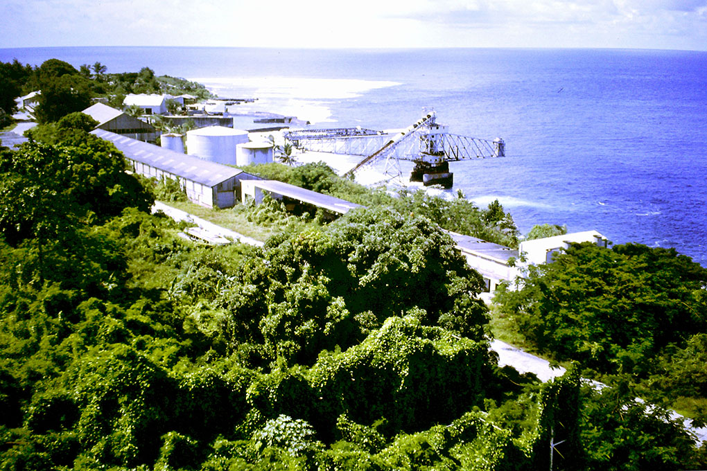
In my October 2017 post about “Conurbation”, I made brief reference to the heat island effect I had seen first-hand at Ocean Island in the Central Western Pacific. The story of Ocean Island or “Banaba” has always struck me as being like an ecological mirror of our own planet and if you can think for one moment about our fragile planet as being like a Pale Blue Dot cast adrift somewhere in the dark depths of space, then spare a thought for solitary Ocean Island sitting out there in the vast Pacific, all on its own.
Abandoned and overgrown mining infrastructure at Ocean Island (Banaba) in the Central Western Pacific, (writer’s picture).
Like the Pale Blue Dot, Ocean Island was the only home its native inhabitants had ever known. That was before the mining industry realized its potential. Roughly two square miles in area or to reference our subject, twice the size of Yallambie, an 80-year long phosphate mining industry in the 20th century reduced the island to a weedy, post-apocalyptic, post-industrial moonscape of broken rock and abandoned mining buildings and machinery. Unlike the inhabitants of the Pale Blue Dot however, a new home was found for the local people, the Banabans who were relocated to a small island in the Fiji group, much to the detriment of their heritage and to their identity as a Micronesian people.
Early 20th century photograph of Banabans in traditional dress on Ocean (Banaba) Island. (Source: A St. C Compton collection)
The phosphate from Ocean Island was meanwhile used to green farm land in Australia throughout most of the last century, so look around you. There’s probably a little bit of Ocean Island below your feet at Yallambie even now.
The sacrifice of the island to the needs of an industry that aided an agricultural revolution in the 20th century resulting in the population of this planet increasing from 1 ½ billion when mining started in 1900 to 7 ½ billion and climbing today, is an irony. The industry left the island source of a small part of that revolution largely uninhabitable but even so, there is a bigger irony at work here. Should general industrial practices across this planet result in Global Warming and a rise in sea levels which is a fundamental prediction of many expert opinions, then ruinous Ocean Island as a raised atoll and politically a part of the Republic of Kiribati will be the only island within that nation that has the potential of remaining above those projected altered sea levels.
It’s a sobering thought and one that might see future peoples of low lying islands calling out the name of a certain American writer as they measure the water outside their front door. Whoever first spoke those somehow Global Warmingly appropriate words, “Everybody talks about the weather, but nobody does anything about it,” the source doesn’t really matter now. It seems instead appropriate that the pen name of Samuel Langhorne Clemens, which found its origins from his years working on the Mississippi riverboats where a safe depth for passage was called out as two fathoms on the line – “by the mark twain” – could one day find another use. In years to come as the waters rise, we might all be hearing a bit more about the “Mark Twain”.
It was in the cold, glowing, radioactive light of the Post-Apocalyptic new day that the truth was unveiled. The facts were utterly undeniable, even by that seemingly discredited Godzilla, post-Karen Silkwood institution which constitutes the nuclear power industry of this 21st century island Earth. A little over a year after the nuclear melt downs at the Fukushima nuclear power station following the 2011 earthquake and tsunami in Japan, an independent investigating commission found that, given the earthquake prone nature of the country, the disaster had been entirely predictable and that the safety failures that occurred during the crisis should therefore have been perfectly preventable.
It was a finding that was of little comfort to those gleaming in the warm, green glow of the nuclear aftermath. The resulting catastrophic release of radioactive material into the environment was a disaster of atomic proportions for Japan and its neighbouring countries around the Pacific Rim, the ongoing effect of which is still being felt and which may not be fully realized yet for decades to come.
With the finger pointing that followed, the operator of the Japanese Fukushima plant subsequently revealed that one of the main reasons for its lack of preparedness was an underlying fear of the negative publicity and protests that might follow any admission of these safety concerns. When it comes to the nuclear industry then, it seems it is better that we don’t know what we don’t know until such time as we know it.
In Yallambie in 1974 a similar line was drawn in the sands of truth when a proposal was made to carve off about eight acres of green fields from the Army camp and build an Australian radiation laboratory in what even then was an emerging suburban environment. The land was part of a Federal Government reserve but since the start of the 1960s it had been leased by an inoffensive pony riding school fronting Lower Plenty Rd near the corner of the present day Yallambie Rd intersection.
Lower Plenty rd, a single lane in either direction at the Yallambie Rd intersection. The timber building prominent in the picture was replaced by the ARL development. (Source: PIT Environmental Impact Statement, 1974)
At the time, the proposal was met with stiff opposition from local residents of Yallambie led by the Yallambie Progress Association which had formed in 1972 to give residents of the embryonic A V Jennings housing estate a voice in local affairs. The Association convinced the Department of the Environment and Conservation to stump up $1000 to pay for the Preston Institute of Technology to write an expert environmental impact statement for the proposed laboratory site. It was a move that was surrounded with a degree of irony as the government Department of the Environment and Conservation was effectively paying to investigate the actions of another government department, the Department of Health, which was the body ultimately responsible for the Australian Radiation Laboratory.
Jim O’Connor who wrote the PIT environmental impact study into the proposed laboratory, (Picture source: The Heidelberger, 12 June, 1974).
The report was written by John O’Connor, an air pollution PHD post graduate from the Centre for Environmental Studies at PIT, Bundoora. His three month study found that the expected radiation created by the laboratory when operational would be about the same amount as the fallout from French nuclear testing in the Pacific, which at that time was becoming a major international environmental concern. On site radioactive waste however was not deemed to be an issue. The report noted that:
“Both low level and high level solid radioactive wastes are to be disposed of at a site remote from Yallambie and do not present a hazard to local residents”.
In light of subsequent developments, it would be interesting now to know what information O’Connor based that statement upon.
The Yallambie Progress Association wrote to the director of the Australian Radiation Laboratory, a Mr D Stevens in May 1974 asking him for a response to a list of 23 questions that the Association had prepared pertaining to the nature of the proposed complex. Mr Stevens reply when received was a typical bureaucratic exercise in evasive double speak:
“It would not be appropriate for me to reply direct to you with answers to your questions. However, you may be assured that answers will be provided at the public hearing of evidence. The Health Department has been advised by the Secretary of the Public Works Committee that explanations, answers to questions and the like should now be part of the evidence presented and considered by the committee.”
Yallambie Progress Association member, Robyn McConville and her daughter in their Woona Crt backyard, Yallambie overlooking the proposed Australian Radiation Laboratory site. (Picture source: The Sun News Pictorial, 17 September, 1974.
Vice President of the Yallambie Progress Association, Doug McConville who lived in Woona Crt at the back of the proposed site at this time said in response, “We should have answers to these questions, otherwise we will not be able to give considered objections.” He might very well have also added, “We don’t know what we don’t know until such time as we know it.”
Nevertheless, a petition opposing the proposed laboratory was signed by 342 local residents and presented to the Joint Parliamentary Standing Committee on Public Works which sent members to visit the site before convening a meeting at the old Lower Plenty Community Hall behind the Lower Plenty shops to discuss the issue over a two day period in September, 1974. Members of the Yallambie Progress Association took time off from their busy working lives to attend the meeting which was chaired by Keith Johnson, MHR in the wide tied Whitlam era government, with seven of the eight bi-partisan Parliamentary Standing Committee members present. A 22 page “Statement of Opinion on Behalf of the Residents of Yallambie” was tabled detailing residents many concerns with the proposed development.
The ARPANSA building visible through the trees in its suburban location as seen from the southern end of Yallambie Road, September, 2018.
The result was of course a foregone conclusion. The Government needed a site for their laboratory. It needed it to be on land owned by the Federal Government. It needed it to be within the area of metropolitan Melbourne, in reasonable proximity to Melbourne airport and suburban hospitals and also easily accessible from the City. Oh, and it had to be a place no one had ever heard of. Yallambie ticked the boxes, especially the last. In a story probably familiar to followers of the more recent saga of North East Link, a decision may have been made behind closed doors months before the public meeting was played out. The resulting resolution in favour was suitably rubber stamped and construction commenced, the only concession to residents’ wishes being the adoption of a policy to overplant the area with native trees.
River red gum and pond at “Streeton Views”, Yallambie, March, 2015
The design approved by the Standing Committee placed the “high radioactive areas” in the basement of the east wing of the complex with the direction of radiation going westwards into the undulating hillside. “As earth is an excellent absorber of radiation, this has lowered the amount of shielding that would have been required by other means”. (Standing Committee, Fifth Report, 1974) As the Streeton Views estate was subsequently constructed on that hillside, one would hope that the earth really is the “excellent absorber” described in that 1974 report.
Architect’s rendering of the ARL proposal at Yallambie. (Source: Report on the ARL proposal at Yallambie, Parliamentary Standing Committee on Public Works, Fifth Report, 1974)
Three 5000 gallon holding tanks were planned as part of the construction, capable of holding low level radioactive waste with the intention of developing a regime of watering the waste down and disposing of it regularly into the Metropolitan sewerage system. The Standing Committee Report noted that this was a standard practice provided for in the Victorian Radioactive Substances Regulations and in similar legislation in other states. The report did not mention any plans for ongoing storage facilities of solid radioactive wastes.
The facility was budgeted at $3,600,000, which was about three times the price the Whitlam Government controversially paid for Pollock’s Blue Poles in the same era. Which do you think was the better bargain?
The Australian Radiation Laboratory moved into the building four years later with their stated objectives at that time being to provide protection standards and codes of practice for radiation emitting devices throughout Australia and to maintain standards in radiopharmaceutical drugs used in nuclear medicine.
A sullen silence descended over the facility, the young trees shadowing the new property like a dark veil of secrecy surrounding the site. What was really going on in there? It was anybody’s guess. The minutes of the Yallambie Progress Association indicate the ongoing concerns of local residents. Minutes from the Annual General Meeting in March, 1986 show correspondence from Victorian State Premier John Cain offering “assurance of no dumping of radioactive waste at the Nat Radiation Lab at Yallambie”. As the site had always been controlled by the Federal Government it is unclear why Mr Cain felt he was in a position to offer this assurance. Maybe it was wishful thinking.
A 1981 aerial survey of the area showing the proximity of the ARL facility to Yallambie and Viewbank.A 2018 view of the ARL ARPANSA site surrounded by the suburban streets of Yallambie and Viewbank.
In 1992 the Yallambie Progress Association noted a newspaper article that stated Victoria’s radioactive wastes were stored at four locations – East Sale, Bandiana near Wodonga, Broadmeadows and “Lower Plenty”. The newspaper article went on to say that some of the locations were deemed to be inadequate for storing radioactive material, noting that one of the four sites “was in a flood-prone area”. (Herald-Sun, 1 June, 1992) As the Yallambie facility was built next to the outfall of the Yallambie Creek near its confluence with the lower reaches of the Plenty River, a site that had been known to flood previously, it seems pretty clear which site the newspaper article was describing as inadequate.
The proposed ARL site flooded by the Yallambie Creek. (Source: PIT Environmental Impact Statement, 1974)
In 1998 the Australian Radiation Laboratory changed its name to ARPANSA (the Australian Radiation Protection and Nuclear Safety Agency) in a move some thought was a cynical attempt by the Laboratory to appease the great unwashed by removing the unfriendly word “Radiation” from its letterhead altogether. It’s been 40 years now since the radiation facility first started their operations at Yallambie but residents in the back streets of the south east end of our suburb, together with those in neighbouring Viewbank might have wondered what was up this year at ARPANSA. The obvious thing was a crane. It appeared in the sky over the tree tops at the back of the facility and stayed there for months. But what was it for?
ARPANSA photographed from the Viewbank side of Lower Plenty Rd, September, 2018.
Last week an article by Clay Lucas appeared in the columns of The Age newspaper which gave a hint. Clay reported that an FOI request had revealed that 210 drums of waste from the former Commonwealth Radium Laboratory at Melbourne University had been marked for indefinite disposal at the ARPANSA facility at Yallambie and that the removal to the site which had started on the quiet was already well under way. The material had been classified as “suitable for disposal in engineered near-surface facilities and [requiring] isolation and containment for periods of up to a few hundred years” but alarmingly an ARPANSA spokeswoman was also reported as saying that the 210 drums from the University represented only “a tiny percentage of the radioactive waste held at the facility – 0.1 per cent.” By their own admission then they were suggesting that the facility is holding a staggering 210,000 barrels of radioactive waste at Yallambie.
I beg your pardon, what?
Surely that is an exaggeration of the facility, or as is more likely, a fault with the finger counting of my school grade mathematics. The FOI request asked for a public disclosure to be made about the arrangements of payments between ARPANSA and the University but this had been denied with the plan deemed as being “subject to a confidential memorandum of understanding”, while the University itself described the arrangement as “commercial-in-confidence”.
In July, 1992 the Keating Government announced it would find a site for a national storage site for the “relatively” small amounts of nuclear waste materials produced in Australia. More than 25 years on and with multiple changes of government the Feds are still looking. The trouble is, while all the states think the proposal of a National storage site is a pretty good idea in principle, that principle only holds true if the site is not in your own back yard.
The Age newspaper story last week about the radioactive material going on its one way journey to Yallambie asks more questions than it has answered. Looking back over the old minutes of the Yallambie Progress Association from the 1970s it is clear to me that even with all the strong objections that were mounted at that time to the construction of the Radiation Laboratory, it was never suggested that the facility would later become a defacto nuclear waste dumping ground. Former members of the Yallambie Progress Association and long-time Yallambie residents, Alec and Brenda Demetris told me on Friday when I discussed this with them that if they had known in their younger days what would be revealed this week in The Age, they would not have been writing petitions and reports in 1974. They would have been chaining themselves to the builders’ fencing.
There’s been a fair bit of conjecture about the need for Orwellian truth in society of late. The tabling of a mountain of documents in State Parliament about an old planning decision gone wrong is said to set a dangerous precedent for the system of Westminster Government in Victoria. I say, bring it on. It’s time to fess up. Those outdated and undemocratic conventions where governments can hide their decisions behind a veil of secrecy for decades need to be reversed as it is only by disclosure that freedom of information and the public’s right to know can be satisfied in a democratic society. If the people of Fukushima had known what they didn’t know before the time that they knew it, would the power station operator have been able to leave the Fukushima plant so inadequately prepared for the disaster that overtook it? If we had known in the past what questions to ask about the radioactive waste dump that has been allowed to operate at Yallambie, would it have been able to exist in the middle suburbs of Melbourne for so long?
It was a name given to him affectionately by his fellow artists as a passing nod to his organized ways. They started out as a loose association in the mid ’80s in what was then semi-rural Box Hill, experimenting with plein air painting, but as suburbia overtook the artists’ camps along the Gardiners Creek they relocated to a new camp on “Mount Eagle”, at an old cottage at what is now Summit Drive in Eaglemont near Heidelberg, cementing in our consciousness by doing so an art movement that would forever be remembered as the “Heidelberg School”, Australia’s first nationally focused art movement.
Heidelberg Historical Society marker in Summit Drive, Eaglemont.Charterisville in Ivanhoe, built by David Charteris McArthur, c1845. (Heidelberg Historical Society picture)
Typically it was Walter (Walt) Withers, The Colonel, who found them another home when the group moved from the Eaglemont cottage. In September, 1890 Withers arranged a lease on the late David Charteris MacArthur’s “Charterisville”, just to the south of Mount Eagle, and here he painted and taught while subletting the lodges to a procession of his fellow artists. The contemporary critic Sidney Dickinson named him, along with Arthur Streeton, as a leader of the “Heidelberg School”, which in Withers’ case was almost certainly an exaggeration, but there is no doubting his significant role within the group.
Portrait of the Heidelberg School artist, Walter Withers, 1854 – 1914. Source: Wikipedia
In the critical period between 1889-90, at a time when Frederick McCubbin and several others were still painting in a conventional style, it has been noted that Withers “was experimenting with a brave and confident impressionistic style” and that “he was probably the first artist to paint major works using techniques of impasto”, (holmes à court Gallery).
When the Heidelberg School artists dispersed to other places after those “Glorious Summers” of the late 80s and early 90s, it was the English born Withers who chose to stay on in the Heidelberg district and paint impressions of the Australian bush while the Australian born Streeton left to paint in foreign fields and the real leader of the Heidelberg School, Tom Roberts was lost to portraiture. Withers alone remained, the sight of his bicycle with canvas and painting box strapped on board becoming a regular sight throughout the Heidelberg district.
Walter Withers’ studio at Cape Street, Heidelberg, c1894.
In 1894, with his wife Fanny and the beginnings of their family of six children, Walt leased another house in Cape St, Heidelberg where he taught painting while maintaining a city studio.
Four years later the Withers family moved again to a new home, “Withers Court” on the corner of Darebin and Hawdon Streets, Heidelberg and it was probably there or at Cape Street that the grown up daughters of Yallambie’s Thomas Wragge took painting lessons from him, learning techniques they would bring to their home to paint selected interior joinery at the homestead.
Wragge painted four panel door at Yallambie.
Possibly it was a social as well as an artistic outlet for the Wragge girls. Their mother, Sarah Anne Wragge wrote cryptically and critically in 1898 in a letter that she believed her daughters weren’t learning much about painting under the artist’s supervision.
“So Jessie has finished her paintings at last, and I quite think with you that there must be more talk than work at that studio.” (Sarah Anne Wragge – her underline – quoted by Calder: Classing the Wool and Counting the Bales)
The stableyard at Yallambie, c1900 by Sarah Annie Wragge showing the Bakewell era stables on the left and stableyard wall, both now demolished. Laundry building at right. I’m thinking maybe Annie couldn’t paint horses? (Source: Bill Bush collection)
Sarah Annie Wragge hand decorating a door at Yallambie Homestead, c1890. Source: Bill Bush collection
The weather boarded Withers Court house still stands next to the rail tunnel in Heidelberg near to where the current duplication of the rail line between Heidelberg and Rosanna is right now, in a way that is pertinent to this story, reshaping the surrounding landscape. It was the building of the original cutting and rail tunnel under Darebin Street that determined Walt to move his family from Heidelberg in 1903 to a new location in Eltham. A large rock, blasted from the Heidelberg cutting, had crashed through the roof of his studio and damaged the canvas he had been working on, making Walt’s mind up in the process that it was high time to move on.
Southernwood, Walt Withers’ former home on Bolton St, Eltham and the site of a major road reconstruction, November, 2017.Walt Withers old studio at Southernwood as it appeared during a sale of the home in 2011. Source: DomainThe rail tunnel built under Darebin St, Heidelberg in 1901 and currently in the process of being rebuilt with duplicated line, November, 2017.
The Withers family relocated to “Southernwood”, a small farm set on 2 ½ acres on Bolton St, Eltham opposite the Montmorency Estate where he built a large adjoining studio. Here he spent the last 10 years of his life, famously painting many scenes in and around Eltham while still continuing to roam further afield on his bicycle as the painting mood took him.
Tranquil Winter, Walt Withers, 1895. The house on the ridge is still standing today in Walker Court, Viewbank. This masterpiece was singled out for praise at the time by the eminent British critic, R.A. M. Stevenson, but today is not on general display. Source: National Gallery of Victoria
He was living there, dividing his time by spending weekdays at his city studio and his weekends with his family at Southernwood when one day in 1907 he headed off from Eltham on a painting expedition on the road to Heidelberg. The result of that day, a small, loosely painted plein air oil sketch, which is now in the collection of the National Gallery of Victoria alongside some other more well-known and polished Withers’ masterpieces, carries the somewhat misleading title, “Spring on the Lower Plenty Road, Heidelberg”. The title has helped to obscure the identity of this sketch for a hundred years as the result of a close inspection of the painting, which is freely available to view online the NGV web site, has only now revealed some rather familiar details.
In 1907 “Heidelberg” would have been a somewhat generic term. The old blue stone, Lower Plenty Road Bridge marked the official separation of Lower Plenty and Main Roads but it was on the Lower Plenty or Main Rd side that Walt appears to have set up his easel that day to paint the sort of rural Australian scene so beloved by him.
Looking north east along Main Rd from the corner of the Plenty Bridge Hotel, from a screen still of original footage of the opening of the Heidelberg Golf Club. The trees on the side of the road pictured here are a feature of Withers “Spring on the Lower Plenty Road, Heidelberg” (sic).
The apparently anonymous building in the painting on the left side of the road is on closer study quite obviously a loose interpretation of nothing other than the old Plenty Bridge Hotel, the story of which has been recounted on several occasions within the pages of this blog.
A much later picture of the Golf Club Hotel, AKA, the Plenty Bridge Hotel, looking south west, c1950 but clearly showing the service wing set a right angles to the main buillding.
From the service wing with chimney, set at right angles to the main building, the post and rail fence on the opposite side of the road and the poplars planted at the far end of the building – the details are all there.
John Irwin balancing on Mick Noonan’s motor bike, outside the Plenty Bridge Hotel, c1950. This is perhaps the only known photograph that offers a glimpse of the eastern approach to the old Lower Plenty Road Bridge past the PBH, the direction chosen by Withers in “Spring on the Lower Plenty Road, Heidelberg” (sic). Source: the John Irwin family collection
It was a light bulb moment when I was looking at this painting on the NGV web site and realised what I was really looking at. Withers has painted the land fall past the front of the PBH towards the valley of the Lower Plenty River, showing the road stretching towards the approaches of the bridge, hidden by the bend, just as it is today.
It got me thinking and to doing a little reading. Two versions of a biography of Walt Withers written by his widow Fanny have been reproduced in Andrew Mackenzie’s 1987 book, “Walter Withers – The Forgotten Manuscripts”. The longer of these two biographies, somewhat misleadingly titled, “A Short Biography of Walt Withers”, was published by Withers’ fellow Heidelberg School artist Alexander McCubbin in about 1920. Together, the two biographies contain Fanny’s written descriptions of many of her husband’s artworks and reading through them they make for some rather interesting details in the telling.
The Plenty Bridge Hotel, c1928. Panorama made from screen stills of original footage of the opening of the Heidelberg Golf Club. Although this picture is looking in the opposite direction to Withers “Spring on the Lower Plenty Road, Heidelberg” (sic) many of the details painted by the artist are discernable here.
In 1907 Withers had painted a major canvas which Fanny called “Springtime on the Lower Plenty”, or “The Valley of the Lower Plenty, Victoria”, the obverse of which contained a replica of another Withers work. The story of the main painting as explained in Fanny’s writing is confusing because she freely interchanges the titles of her husband’s artworks in the context of the two biographies, but from the description “Springtime” was obviously an enlarged, studio version of the NGV oil sketch. I use the third person singular indicative as sadly the painting was destroyed in a devastating bush fire at Eltham on Black Friday, 13 January 1939.
Fortunately another painting of the same subject but painted in the tones of Autumn, “but from another point of view” was started at about the same time as “Springtime” and was worked on by Withers on and off up until the day he died. This painting has been called both “The Return from the Harvest” and “The Valley of the Lower Plenty” which makes for more confusion but Fanny wrote that it was a favourite of the artist and the largest canvas her husband ever worked upon.
“Again a road subject, with three figures, swags on their backs, two together and one following behind, walking with swinging steps towards the small hotel, nestling amongst the trees, at the side of the road. The time is Autumn, and the colouring rich and full toned. This painting is the most romantic of the painter’s work. It was much beloved by him, and it was the last canvas he painted on, the sky being completed by him the day before he was seized by his last attack of illness.” (Fanny Withers writing in “The Life and Work of Walter Withers, Landscape Painter.)
The painting was purchased and gifted to the Geelong Art Gallery which inexplicably today does not keep it on current display. It is some years since I saw the painting in the Geelong gallery myself and my memory of it is vague but clearly from the above description the painting is another image produced from painting expeditions to the countryside around the Plenty Bridge Hotel.
Thumbnail of “The Valley of the Lower Plenty”, Walt Withers. Source: Geelong GalleryLooking towards Lower Plenty in the 1920s from a viewpoint similar to “The Valley of the Lower Plenty” but much closer to the bridge.
Recent attempts to gain a viewing of the original of this artwork at Geelong have been unsuccessful. The very poor resolution reproduction from the Gallery shown here does not allow for an observation of “the small hotel, nestling amongst the trees” described by Fanny but it does give a general feeling of the landscape on the western approach to the Old Lower Plenty Road Bridge. In this painting the trees on the left hand side of the picture mark the southern boundary of Thomas Wragge’s Yallambie and one is left wondering whether the three swagmen returning “from the harvest” and painted by Withers might have been itinerant field workers going for a drink at the Plenty Bridge Hotel after a long day working in the Yallambie fields.
The Plenty Bridge Hotel and the western abutments of the Lower Plenty Road Bridge, c1927. Panorama made from screen stills of original footage of the opening of the Heidelberg Golf Club.Drawing of Rose Chapel, (St Katherine’s) at St Helena by Victor Cobb, 1935. Withers was buried here in 1914. The building was burned almost to the ground in a bush fire in 1957 but rebuilt. It is interesting to note that the reverse side of this original drawing bears the artist’s inscription describing it as a drawing of “Rose Chapel, St Helena, Eltham”, evidence of how place names like Heidelberg and Eltham were generic district terms used loosely by artists. Private collection
Maybe Walt even dropped by the Homestead that day to pay a visit to his former painting students, heading off with Sarah Annie’s husband, Walter Murdoch for a drink, as was Murdoch’s want, at the Plenty Bridge soon afterwards. It’s a thought.
Plagued by ill health later in life, Walt Withers died at Eltham of cerebral thrombosis on 13th October, 1914 aged just 59 years.
His daughter remembered him as being six feet tall in his socks and solidly built, with brown hair slightly curling at the sides, big, soft, hazel eyes and a large, bushy moustache. He is buried in the church side graveyard at the Rose Chapel (St Katherine’s), St Helena.
Writing in the forward of Andrew Mackenzie’s book, Kathleen Mangan, the daughter of Charles McCubbin wrote of the Heidelberg School artists that:
“…it was a time of freedom of spirit, gaiety, and great artistic and intellectual advancement, a glorious burst of artistic achievement which erupted into flame at the end of the eighties and the beginning of the nineties, a flame that was all too quickly extinguished by the Outbreak of World War One.”
The Great War was only two months old when Withers died. The artist mantra in the district passed to others, the colonies at Montsavat in Eltham and the Heide Circle at Bulleen becoming just two expressions. A story from the Heidelberg Artists Society of an incident involving artists during the Second War has a certain relevance to the Yallambie story. It is recorded that one day around 1940, two painters had set up their easels in the vicinity of Banyule Rd when a farmer armed with a shotgun and accompanied by a couple of enormous dogs arrived on the scene demanding to know their business. The artists were dressed for painting in Army disposals – slouch hats and blue boiler suits – while from a distance their easels might have been mistaken for surveyors’ tripods.
Army cadets at Camp Q, Watsonia, (Yallambie), 1944. Source: Australian War Memorial
At that time the Army had just resumed a part of the old Yallambie Estate nearby to create Camp Q (Watsonia), now known as the Simpson Barracks, and the unnamed farmer feared that a survey heralding a forced annexation of his own land was about to take place. Summing up the relative sizes of the farmer’s firearm and the jaws of his hungry hounds, the artists wisely packed away their easels for another day, the decision possibly a loss to art but a gain for rural diplomacy in the district.
YALLAMBEE by George Alexander Gilbert. Source: State Library of VictoriaThe Station Plenty, (Yallambie) view VI by E L Bateman 1853-1856. Source: National Gallery of Victoria
The association of the work of Walt Withers with the story of the Yallambie area joins the tradition of the earlier pictures of A E Gilbert and E L Bateman and the writings of Richard and William Howitt and Louisa Anne Meredith. For all that, the work of Walt Withers has fallen somewhat out of favour in recent years. Not one of the paintings he produced in and around the Heidelberg and Eltham districts and that are now in public ownership are currently on display at the galleries. “The Return from the Harvest”, AKA “The Valley of the Lower Plenty”, described by Fanny as “the most romantic of the painter’s work… much beloved by him” and likewise the NGV’s oil sketch “Springtime” must remain therefore, at least for present time, unobserved.
Site of former Plenty Bridge Hotel, looking south west, November, 2014
Heightening this unfortunate circumstance is the reality of the danger posed to the artists’ footsteps by the plans of the North East Link Authority, a subject and side subject of this blog in recent times. The location of the two Walt Withers paintings discussed above stands under direct threat of the potential building of a Corridor B through Yallambie and Lower Plenty. The tranquillity of Walt Withers churchyard grave at St Helena would be broken by the building of a Corridor C. And the implications of Corridor A on the legacy of the Heidelberg School in Banyule goes without saying.
Does anybody care?
His paintings largely forgotten, his Plenty Valley and Heidelberg subjects at risk of being despoiled by the road builders – poor Walt, “The Orderly Colonel” must be turning over in his St Helena grave.
Legend has it that a dozen years or so before the founding of Melbourne, a South American pirate by the name of Benito Bonito took brief refuge at Port Phillip while on the run from the Royal Navy with the stolen “Treasures of Lima” in his hold. There in a cave at Pt Nepean it is said the pirate hid a fabulous hoard, sealing the entrance afterwards with an explosion of gunpowder. As you might expect from such a story, Bonito reportedly met his end soon after at the end of a rope hanging from an English yard arm but be that as it may, one thing is certain, the so called “Lost Lima Treasure” was never seen again.
Many doubted the origins of the tale and indeed whether Bonito had ever been anywhere near Port Phillip but the story persisted, gaining some currency 20 years later when a man turned up in the new settlement at Melbourne claiming to have been a cabin boy on Bonito’s pirate ship. Sporting a map tattooed onto his arm as a supposed proof of the existence of the pirate treasure, the old sailor found willing ears and wishful thinkers in the infant township. The map itself was no doubt a fake, used to con free drinks from gullible patrons in Melbourne’s early shanties but it did fuel an ongoing hope in the improbable. Numerous gopher holes soon appeared in the sand dunes at Pt Nepean, the work of would be treasure hunters or what is more likely literally true, eternal optimists.
It was the visiting American writer Mark Twain who once said that the history of Australia “does not read like history, but like the most beautiful lies,” and further west along the Victorian coast another story, the legend of the “Mahogany Ship” sits somewhat nicely into this same category. It too involves a story of early map making and forgotten voyages into Australian seas, but in the case of the Mahogany Ship, the origins of the story are placed even earlier.
The legend of the Mahogany Ship revolves around the reported siting of an ancient shipwreck on the beach at Warrnambool in the 1840s. Contemporary eyewitness accounts described it as being of “antique design” of “hard dark timber – like mahogany” and sitting high in the sand dunes at a considerable distance from the high water mark. By the later years of the 19th century the shifting dunes had covered the wreck and its remembered location had been forgotten but by one count, 27 different eyewitness reports had been recorded and it was later speculated from these descriptions that the wreck had been a 16th century Portuguese caravel, lost on the south coast of Victoria during a voyage of discovery by Cristóvão de Mendonça in 1522. The theory goes that knowledge of the voyage and the maps made during it had been suppressed due to the Portuguese operating in what had then been deemed to be Spanish waters under the Treaty of Tordesillas, and that any other evidence was subsequently lost in the Great Lisbon earthquake of 1755. To further the story, an ambiguous French copy of a Portuguese map purporting to show a Great South Land, “Jave la Grande” survived at Dieppe and this has been used by advocates of the Mahogany Ship story as confirmation of its truth ever since.
World map by Nicolas Desliens, 1566.
Mendonca aside, there is no doubting the importance of having a good map to find your place in the world and when Captain Cook arrived on the east coast of Australia in 1770 without one, the uncharted Great Barrier Reef very nearly caused his ruin off the coast of north east Queensland. With HM Bark Endeavour holed and fast taking on water, disaster loomed as Cook showed an almost uncanny presentiment to find the mouth of the Endeavour River, the only place for miles around where he could possibly beach his ship for repair. Some adherents to the Mahogany Ship story have suggested that Cook’s ability to navigate through treacherous reefs to safety owed more to his knowledge of ancient Portuguese maps than his own 18th century sailing ability, a suggestion that almost certainly does Great Britain’s greatest navigator a disservice, but it makes for an interesting conspiracy theory all the same.
Bakewell era survey map of Yallambee.
Any study of the past inevitably involves map making and Yallambie is no exception. The Bakewells had a survey of their farm at Yallambee drawn up in the early 1850s, probably at a time when they were contemplating a return to England, and this map has appeared several times within these pages. It is a useful primary source and by comparing the information contained in it to the modern setting it is possible to draw some interesting conclusions about the layout of the Bakewell farm and the context of E L Bateman’s drawings within it and this, for the importance of the record, is worth affirming.
Bakewell plan imposed over the contemporary setting.The Station Plenty, view I by Edward E L Bateman showing from left to right stables, kitchen, dairy and residences. (Source: National Gallery of Victoria)
As has been stated in a previous post, it was the belief of the Wragge descendant, Nancy Bush that the original Bakewell cottage was located where the tennis court was later built, the foundations of the house presumably ending up as the starting point of her family’s grass court surface.
SLV Daguerreotype of Yallambee showing trellis covered walkway. (Source: State Library of Victoria)
A second residential building stretched in a northerly direction up the slope and was connected to the cottage by a trellis covered walkway with a third building, marked as a kitchen wing on the survey map, placed at right angles at the far end. The location of these additional buildings is now largely buried under the floors of the Wragge era Yallambie Homestead.
The Station Plenty, view VI by E L Bateman showing relation of cottage and secondary buildings to the large dairy structure. (Source: National Gallery of Victoria)
A fence across the kitchen yard enclosed the southern end of a large building marked “dairy” on the Bakewell plan and this building was located where the smaller, present day Yallambie dairy stands to this day.
The Station Plenty, view III by E L Bateman showing in detail a curious access door below the floor of the dairy at the rear of the cottage. (Source: National Gallery of Victoria)
Another Nancy Bush belief held that the original cellar was located under the dairy and in Bateman’s Plenty Station View III which shows the southern end of this building behind the cottage, there would appear to be some sort of underground access into the side of the far building to confirm this.
Yallambie Homestead and Bakewell era stables, corner of Tarcoola Drive and Lambruk Court, c1970
North of the structure marked “hothouse” on the plan was a stable yard with a large stable block located on the eastern boundary and this building was still standing into the early 1980s when a modern mud brick home was built to replace it. Beyond the stables was a tool house and rick yard with a shrubbery and William Greig’s old hut and garden completing the picture within the immediate surrounds of the house.
The Station Plenty, view XII by E L Bateman showing what was probably William Greig’s old hut. (Source: National Gallery of Victoria)Corridor B Lower Plenty Rd interchange. Map (detail) from North East Link Authority web site.
The North East Link Authority when it made its bombshell announcement at the start of August about smashing a Freeway through Yallambie, released their own map of their plans but anyone who has tried looking at this map has found that it remains frustratingly unclear about the real intentions of their strategic planners. Their web site is little more than a sales pitch which studiously avoids any attempt at revealing too many facts while the so called pop up community consultation meetings that have been staged at various locations across the community have been even less use, an equal part spin and sometimes downright disinformation. At one of these recent meetings it was stated that a diamond shaped corridor B interchange at Lower Plenty Rd would go under the river and not over it and that it would be located on the eastern side of Main Rd. Oh, but tellingly that, “nothing has been decided”.
The lads at North East Link seem to have taken a leaf out of Nietzche’s book who famously said, “There are no facts, only interpretations.” The unstated fact is that trucks using the anticipated interchange would certainly require a grade of no more than 4%, so it is an impossibility to take the road in a tunnel under the Plenty River while still arriving at a meaningful level to connect access roads to Main and Lower Plenty Roads. Taking a road under the Plenty River flood plain would also involve tunnelling through a geologically unstable water table requiring constant pumping throughout the life of the road. My interpretation of the proposal is that if built, (perish the thought) the intention of North East Link is to exit the tunnel near the corner of Binowee Avenue and Moola Close, Yallambie and cross the Yallambie Flats on an elevated flyover and that saying otherwise is just a further attempt to draw a smoke screen over the whole exercise. Should corridor B ever be given the nod, when it comes to the crunch the engineers would wade in, the spin doctors would stand aside and the practicalities and liabilities of their plan would finally be admitted.
Construction of elevated rail near Murrumbeena station. Picture: Nicole Garmston, Herald Sun 30 August, 2017
As the Herald Sun reported in a front page story on Wednesday, the full effect of a similar solution to another transport problem is only now beginning to be understood as the reality takes shape in Melbourne’s southeast.
Digitally altered image showing conjectural North East Link road crossing river flats at Yallambie.
Just picture for a moment a road of at least six, but more likely eight lanes stretching across the Plenty River flood plain, but if you can’t, here’s a digitally altered image of a picture I took of the landscape three years ago to give you an idea.
Proposed corridor B route through Yallambie and North East Link road interchange at Lower Plenty.
And just for good measure, the survey map used above but this time with corridor B splashed onto it in all its glory. Absurd as it might look, I think it is likely to be one of the more truthful representations of this unlikely proposal up to date. It’s a large file so click on it for the detail. You might even see your own roof somewhere in there.
It is part of an obvious attempt not to reveal too many facts about any of the proposed routes of North East Link before a final announcement is made later in the year. The late inclusion of corridor B within the proposal I think has a lot to do with the perceptions of Yallambie’s place in the world, or at least perceptions of the suburb in the eye of the authorities.
Melbourne’s road network with proposed North East Links from RA, September, 2017.
In the September edition of “RA”, the magazine of the Royal Automobile Club of Victoria, there is a four page article detailing the North East Link proposal complete with a generalised map by way of illustration. Interestingly the article states that “broadly, NELA has been looking at three possible routes for the proposed freeway,” going on to explain what in effect constitute the options for corridors A, C and D. The route for corridor B through Yallambie doesn’t rate a mention. The implication is that in real terms, corridor B serves the same business model as corridor C but that the Yallambie/Lower Plenty route has been belatedly included as something slightly easier to digest than the unpalatable Eltham option. I expect most people who heard about Yallambie as an alternative to the Eltham route last month had to then go and look up Yallambie on a map because in cartographical terms, when it comes to your place in the world, it’s all about where you draw the line.
Melbourne’s road network with missing links from Vicroads publication “Linking Melbourne”, February, 1994.
If you drive along the top end of Bell Street in West Heidelberg today, an enormous apartment block is right now fast reshaping the landscape, sitting there like a latter day QE2 beached on top of the ridge. This apartment block carries the moniker “The Ivanhoe” in large, friendly letters emblazoned across its Upper Heidelberg Rd frontage and the building has been described by the property developer as being located in the suburb of Ivanhoe. The project website, obviously aimed at an overseas market, describes the suburb of Ivanhoe as “a sanctuary of leafy green streets, parklands and river walks with a strong sense of community and belonging.” The thing is, this description belies its location on the west corner of busy Bell Street and Upper Heidelberg Road. The location of “The Ivanhoe” is actually West Heidelberg, or at best Heidelberg Heights, to use the jargon of real estate agents. The border of the suburb of Ivanhoe ends at Banksia Street but it seems nobody stumping up the money to live in one of these apartments wants to wake up one day and find them self suddenly living in unfavoured West Heidelberg. The solution, just move a line on the map. Do you think anyone will notice?
The ‘Ivanhoe’ Apartments taking shape at the top of Bell Street, West Heidelberg, September, 2017.
North East Link obviously think nobody will notice when it comes down to the nitty gritty of moving lines around a map of their proposed corridors. It’s all about what you reckon you can get away with. The State Government has vowed that one of these suggested routes will have traffic thundering through it in the early 2020s but like Benito Boninto rampaging up and down the Peruvian coast, the Pirates of the North East Link aim to wreak havoc and destruction on impacted communities without so much as a by your leave. The explosion of gunpowder used in a cave at Pt Nepean will be nothing compared to what they have in mind. To them, communities and the people living in them are simply arbitrary boundaries – mere lines to shove around on a map wherever they want – an inconvenience to their plans best not discussed within delicate hearing.
The story of the 16th century Mahogany Ship and the presence of Captain Cook on the east coast of Australia in 1770 long ago entered the blurred line between historical fact and legendary fiction but in the years to come, how will we look back on the Pirates of the North East Link and the last months of 2017? Will the anger and bitterness that these road proposals raised be remembered or will their legacy live on in history as a postscript to the main story, the forgotten doodles in a road planner’s imagination?
“But the plans were on display…”
“On display? I eventually had to go down to the cellar to find them.”
“That’s the display department.”
“With a flashlight.”
“Ah, well, the lights had probably gone.”
“So had the stairs.”
“But look, you found the notice, didn’t you?”
“Yes,” said Arthur, “yes I did. It was on display in the bottom of a locked filing cabinet stuck in a disused lavatory with a sign on the door saying Beware of the Leopard.”
Douglas Adams
Thus Arthur Dent learned at the start of The Hitchhiker’s Guide to the Galaxy of the plans to destroy his home for a new road.
“It’s a bypass. You’ve got to build bypasses.”
This week the State Government through the guise of its North East Link Authority dropped a bombshell. It came right out of left field and landed in the solar plexus of the Yallambie community, catching all and sundry totally by surprise. As I listened to the news of this exploding shell broadcast on early Monday morning radio, I couldn’t help but think I had been weirdly trapped inside a scene from the chapters of a Douglas Adams’ science fiction farce, but this was no laughing matter. Secret proposals have been going on behind closed doors at North East Link and while nobody has been looking, somebody just moved the goal posts.
The North East Link Authority, charged with finding a route for the missing piece in Melbourne’s road system, had just announced a choice of four alternative routes to fill the void in that network. Wikipedia has long listed three of them, an eastern option from the Western Ring Rd to East Link via Kangaroo Ground and Chirnside Park, (corridor D); a central option from the Ring Rd to Eastlink via Eltham and Warrandyte, (corridor C) and a western option from the Ring Rd to the Eastern Freeway at Bulleen via Watsonia and Viewbank, (corridor A). But a fourth, previously un-thought of route has unexpectedly been thrown into the mix by the lads at North East Link. Their so called corridor B. The B is for bomb.
Yallambie.
Kaboom.
In essence corridor B is an afterthought. Maybe even a Furphy. A bad and cynical attempt to wrong foot opposition to an already unpopular road by dividing discussion. If built this unexpected option would be a disaster for Watsonia and Yallambie and would completely and utterly destroy the Lower Plenty township to boot.
The Station Plenty, (Yallambie) view I by Edward La Trobe Bateman. Source: State Library of VictoriaAn imagined North East Link connection at Yallambie seen from across the River at Lower Plenty. The reality would certainly be far worse.
The unique landscape at Yallambie and Lower Plenty has remained largely unchanged since the 1840s and was recognized and classified nearly two decades ago by the National Trust. Who could possibly think the idea of exiting a tunnel over this landscape and filling it with a spaghetti of connecting roads could be a good idea in this day and age? The corridor B proposal aims to smash a gaping hole into all of it (literally) by taking a route off the Greensborough Highway through Watsonia and the northern borders of Yallambie, almost certainly compulsorily acquiring and demolishing the homes of countless families in the process, before plunging underground along the existing electrical easement and spewing out of the ridge directly in front of the Yallambie Homestead. If that old and fragile building does not fall down from the vibrations during the underground blasting process of building the tunnels, then the combined effects of over a hundred thousand vehicles a day travelling on it will.
Yallambie Homestead photographed in 1995.Yallambie Tennis Club, June, 2015.
There are practical considerations for the builders’ of these roads not tunneling under rivers so the proposed corridor B route would presumably follow an elevated flyway across the Yallambie Flats, obliterating the existing soccer ground if not the tennis club in the process before crossing the Plenty River opposite the Lower Plenty Hotel and ripping the heart out of the Lower Plenty township itself.
Soccer ground, Yallambie Park, homestead on the hill, November 2014Lower Plenty Hotel terrace. (Source: David Sarkies, True Local).
You can forget ever having another drink at the Lower Plenty Hotel while marveling at its unique bush land setting.
Lower Plenty, June, 2017.
You can kiss goodbye the Heidelberg Golf Course and the adjacent green wedge of the historic Edward Willis landscape. This proposal is an utter disgrace and would be a catastrophe for this area.
And just for good measure, for those who worry about such things, you can forget about selling your real estate right now. Your house has just become unsellable overnight by the mere mention of this road. So much for Yallambie as the 6th most “in demand suburb” in Australia.
Looking towards Yallambie from Lower Plenty during the farming era
What could they have been thinking? Who are the Vogons who dream up these ideas without a by your leave and then try to back pedal them as a realistic alternative to an existing transport problem?
But no, that’s not the end of it. The road they call corridor B would then travel through the back of Lower Plenty for an unspecified length before heading back underground again only to emerge and bash a path through the edge of Warrandyte and Donvale at Reynolds Road in order to meet up with Eastlink. How many communities do these planners plan to destroy along their merry way?
I was a child growing up in Rosanna when the battle lines were first drawn up in the 1970s to stop construction of what was then known as the F18 Freeway. That road aimed to carve a surface route through the back streets of the former City of Heidelberg. I might have been a kid but I remember the adults around me mobilising public opinion, attending protest rallies and vowing to lie down in front of the bulldozers if it came to the point. The years have moved on and those remembered adults of my youth are now all dead but still the fight marches on and into another generation.
I’ve been writing regularly in these pages for three years about the merits of this very special corner of the world. My writing has been an attempt to draw attention to Yallambie, its natural beauty, its historic stories and the fantastic lifestyle to be enjoyed while living on the lower reaches of the nearby precious Plenty River. I’ve mentioned in these pages the possibility of a North East Link more than once, the last occasion in my May post of this year. In my wildest dreams though I never imagined for one moment that this hot potato would fall out of the fire so close to home and that the decision makers would pull this one on us like a Yallambie rabbit out of a hat. It might be sleight of hand but they’re not fooling anyone.
National Trust map showing the extent of their 1998 classification at Yallambie. The proposed North East Link freeway would emerge from a tunnel under the high voltage transmission line easement on the western boundary of the classification and cross National Trust classified land to Lower Plenty on the eastern bank of the Plenty.
Let’s call a spade a spade and call this proposal for what it is. An absolute turkey that has only been suggested now to deflect attention because of the real fight the government knows it will have on its hands with the other routes. The other corridors have been on the cards for many, many years and local groups opposed to them are well organised and ready for the fight. Before last week this had never even been suggested as an option for Yallambie and the local communities in Yallambie, Lower Plenty and elsewhere have been caught completely unprepared. It is insulting that residents have had to find out about this proposal from the newspapers and radio news. Yallambie is a small suburb and we have always had a small voice, but what consideration has been made for the people living here and elsewhere and for the birds and wild life, the historic landscape and the special bushland setting? What of beauty and nature and all those things that make up life in one of the best living environments in the city of Melbourne?
North East Link proposes to destroy all of that unless we make ourselves heard.
Stand up and have your say now. If we leave this until it is too late it will be no use complaining when you wake up one day to find yourself living in a car yard.
Misty morning with Hoop pine at Yallambie, August, 2014
This morning I woke before the sunrise and lay in bed worrying while I listened to the dawn chorus of singing birds. Would the bell like sounds of the King Parrots soon be replaced by the noise of a hundred thousand vehicles a day spewing from a hole in the ground like the legions of Mordor? As if in answer to my question a lone kookaburra joined in with a tune, the ensuing laughter of its call ringing loudly in my ears. Maybe the kookaburra had been reading those newspapers. The North East Link Authority’s Monday announcement was driven off the front page the next day by a story about the Opposition Leader, a crayfish and the company he keeps. It’s good to keep these things in perspective.
Luckily for Arthur Dent, he was able to hitchhike a lift from a passing spaceship to escape the destruction of his hometown by the bulldozers. The rest of us are not so lucky. The decisions made on Melbourne’s road network in the near future will effect this city and the people living in it for generations to come. The destruction of communities in order to build these roads will look pretty stupid when Peak Oil has stopped vehicles in their tracks and left nothing behind other than a hole in the ground and an inter-generational debt with a fiscal and social implication of almost unimaginable proportions.