The glazed look that creeps across a face when you tell someone you live in Yallambie is the motivation behind this blog. “Where’s Yallambie?” usually follows and after the answer -16km due north east of Melbourne – comes the inevitable, “Oh, is that so? I thought it was in the sticks.”
It is true that the land that makes up the present day suburb that is Yallambie remained rural far longer than it’s close proximity to Victoria’s capital would suggest. But today the locality marks the geographic centre of the City of Banyule and includes a history that dates back to the very earliest days of the Port Phillip district. To give an idea of that history is my aim in these pages. As a good starting point and as an overview it’s probably best to begin with the landscape classification of Yallambie which was made by the National Trust of Australia (Victoria) in 1998.
The full classification follows under.


NAME OF PLACE: Yallambie House & environs and Yallambie Reserve
LOCAL GOVERNMENT AREA: Banyule City Council (formerly City of Heidelberg)
CADASTRAL INFORMATION: Reserved existing public open space on the western banks of the Plenty River from Lower Plenty Road. Private land comprising the remnant garden of Yallambie House 14-18 Tarcoola Drive, Macleod. The total area being about 9ha (22.5 acres).
TYPE OF PLACE: River valley landscape, comprising riparian habitat and horseshoe bend river flat and escarpment.
EXTENT OF CLASSIFICATION: Yallambie Reserve north of Lower Plenty Road to the extension of Allima Avenue and including the environs of Yallambie House and garden.
STATEMENT OF SIGNIFICANCE: The landscape of Yallambie Reserve is of high local significance. It is of Regional significance as a cultural landscape being the site of the former ‘Plenty Station’ and one of the very important early colonial sites. In summary it is significant for the following reasons:
a. Association with John and Robert Bakewell (1840-1867) and the Wragge family from 1872-1960.
b. As site of the ‘Plenty Station’, one of the earliest and best documented colonial settlements.
c. Remnant plantings of pines, hawthorns, oaks, elms, willows and orchard trees. Particularly the surviving Pines (Pinus radiata), Bunya Bunya Pine (Araucaria bidwillii), Hoop Pine (Araucaria cunninghamii), English Oak (Quercus robur), Cypress (Cupressus sp.) and Deodar Cedar (Cedrus deodara).
d. Aesthetic characteristics of the river landscape, and views across and along the river valley from high points.
HISTORY
European History
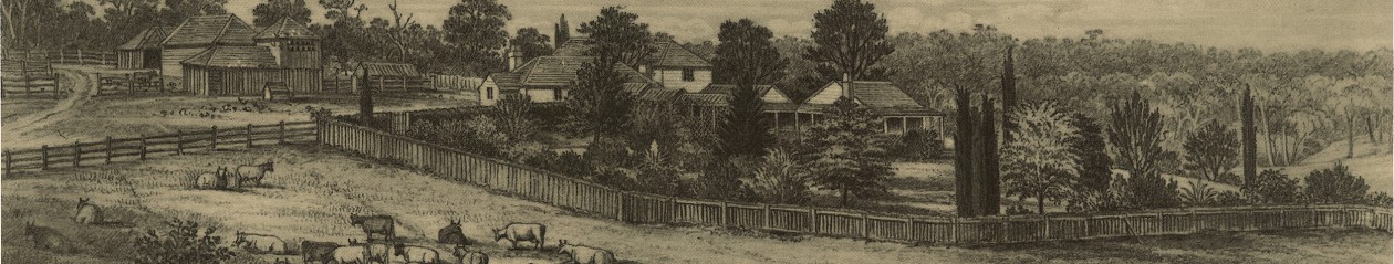
The initial Crown Grant of the Plenty Station (Crown Portion 8) was to Thomas Wills 12 September 1838. This was sold to a neighbour Thomas Walker in 1839 who in turn subdivided and sold most of the land. Brothers John and Robert Bakewell purchased lot 5 (site of Yallambie House) in 1846* for 31 pounds. The Bakewells continued to add to their holding until they owned most of the portion north of Martins Lane and South of Yallambie Rd. Robert Bakewell purchased his brother’s interest in the land in 1859 for 6000 pounds. He retained the property until his death in 1867. It was purchased by Thomas Wragge in 1872. Wragge, a farmer, came to Port Phillip in 1841** from Nottingham. He leased a property on the Plenty River in 1857 and claimed to have started the first orchard in the district. Wragge added to the Yallambie holding and by 1893 his holding totalled 606 acres (245 ha). Thomas Wragge died in 1910 but the family remained in occupation until 1960 when the area north, west and south of the house became a housing estate.
The present house was built on the edge of the Plenty River escarpment between 1872 and 1876. Further improvements were carried out by Wragge’s widow in 1910 and in 1919 by Wragge’s sons. The house is described as having two levels built of stuccoed masonry designed in the Italian style. It has an asymmetric plan, bay windows and stucco ornamentation. The main roof is slate. There is a shingle-covered balustrade to the upper level verandah. Alteration to ground level openings is evident under the verandah but generally the full arch is dominant at the window heads. Corniced guilloche pattern balconettes and corniced stucco chimneys have survived. Extensive interior alterations occurred between 1919 and 1923. Removal of major outbuilding including the stables to the north of the house occurred relatively recently. The house itself is superficially altered and is of low architectural importance but remains as the period focus of the pre subdivision context.
Little of the former orchards of Yallambie remain – a few pears, figs etc. on the river flats. The hawthorn hedged farm track now extends from the public car park off Tarcoola Drive. A number of large pines and oaks also remain on the escarpment and river margins. These plantings provide perhaps the largest and nearest to the original context for an early Victorian house in Banyule. The hill slope and house garden typify the nineteenth century landscape and encapsulate colonial attitudes to nature and land.
DESCRIPTION
Geomorphology
Yallambie Reserve is on the Plenty River some 3 km from its confluence with the Yarra. The river is in a stage of early maturity. The stream profile and widened valley floor indicates that downcutting has significantly decreased except for scour during periods of flood. The river course at Yallambie has changed little over the past 50 years. The reserve itself is mainly a river terrace within a horseshoe bend of the river.
Flora and Fauna
Public access is gained to the horse shoe river flats from Tarcoola Drive. The land slopes down to the flats with an old farm track bordered by a row of Hawthorn (Crataegus sp) trees which provide an aesthetically pleasing entrance to the flats which open up before you as you descend the path. The River flats contains an impressive 100 year old Hoop Pine (Araucaria cunninghamii) and a 120 year old English Oak (Quercus robur) both classified by the National Trust. Remnants of the orchard remain in the form of a number of Pear and Fig trees. The River flats is bordered to the west by a number of homes fronting Tarcoola Drive including the original Yallambie Homestead and a number of remnant trees remain in this area along the escarpment some in the reserve and some in backyards. These trees include Hoop Pines (Araucaria cunninghamii), Bunya Pine (Araucaria bidwillii) and Deodar Cedar (Cedrus deodara).
Other remnant exotics from the homestead era occur throughout the open space including Prickly Pear (Opuntia), Agapanthus (Agapanthus praecox), Cape Broom (Genista monspessulana), European Olive (Oleo europea), Maritime Pine (Pinus pinaster), Monterey Pine (Pinus radiata), Cypress (Cupressus sp.) and Deodar Cedar (Cedrus deodara).
A number of Manna Gums (Eucalyptus viminalis), possibly remnants, exist on the river flat; more of this species appear to have been planted. Along the River are numerous Black Wattles (Acacia mearnsii), Willows (Salix sp.), Swamp Gums (Eucalyptus ovata) and Tussock Grass (Poa sp.).
Unfortunately invasion of the reserve by weeds has occurred in many locations. These include Wandering Jew (Tradescantia albiflora), Cape Ivy (Delairia odorata), Angled Onion (Allium triquetrum), Asparagus (Asparagus officianalis), Bridal Creeper (Myrsiphyllum asparagoides), Great Brome (Bromus diandrus), Blackberry (Rubus sp.) Watsonia (Watsonia sp.), Prairie Grass (Bromus cartharticus), Fumitory (Fumaria sp.) and Honeysuckle (Lonicera japonica).
Aesthetic Characteristics
Yallambie Reserve is an attractive open grassy landscape dotted with Manna Gums and remnant exotic trees. Pleasant views are possible from the elevated areas of the escarpment and from Yallambie over the horseshoe bend of the Plenty River toward the indigenous woodland on the opposite side of the valley. The approach to the Yallambie flat is along a riverside trail and from paths descending from Tarcoola Drive. One of these paths follows an old farm track and is hedged by hawthorns, pines and oaks. Preservation of the integrity of the western escarpment under private management is critical. The owners should be encouraged to participate in sympathetic management.
COMPARATIVE ANALYSIS
With the exception of Gulf Station no early river stations on the Yarra or Plenty Rivers remain relatively intact. Although the Yallambie river station landscape has been modified it nonetheless retains enough elements to allow interpretation of its earlier form. fragments of other river stations in metropolitan Melbourne include the site of Pontville Homestead within Paddle Reserve, Templestowe, but only minimal remnants of the plantings remain. Clarendon Eyre (fmr Springbank), off Bulleen Road, Bulleen, is on the Yarra escarpment but the landscape has been severely modified by recent road works and encroaching subdivision. As a landscape the Yallambie flat is comparable to other river flats on the Yarra but gains its uniqueness from the remnant plantings of large exotic trees and its association with Yallambie House.
Notes:
*The date 1846 in the above classification for the purchase of the house block would appear to be an error. According to Calder, (Classing the Wool and Counting the Bales), the land on which the residence stood was purchased by the Bakewells in July 1842. Certainly, Richard Howitt is known to have visited the Bakewells in their home at the Plenty Station in August 1842 where by that time they were already well established, “the first country newness being over”. (Richard Howitt, Impressions of Australia Felix).
**The date 1841 for Wragge’s arrival would also appear to be an error. (Ibid, Calder), Thomas Wragge arrived at Port Phillip in November, 1851.

