Tag Archives: Yan Yean Reservoir

A river runs through it

What do you think you would catch if you threw a fishing line into the Plenty River at Yallambie? A Redfin perhaps? The “Salmon of Doubt”? An old boot?

I was walking in Yallambie Park the other day below Tarcoola Drive and heard movements on the river bank below me. A few Yallambie likely lads and their girlfriends were down by the riverside with fishing gear and lines trailing into the water. The esky they had brought along with them probably contained little in the way of a catch, but at a guess, lots in the way of lager, the obligatory essential for a good day’s fishing anywhere.

Although the sight of Yallambie anglers is about as uncommon these days as a monster in Loch Ness, a few die hard fishermen are still seen now and then elsewhere along the river. There were plenty of fish in the Plenty once upon a time, enough even for an angling club to form upstream from Yallambie at Greensborough in 1926.

Greensborough and District Angling Club rooms at 161 Para Rd (formerly Rattray Rd), Greensborough

Under the name of the “Greensborough Angling Club”, it met initially at the Greensborough Masonic Hall in Ester St before building premises on the west bank of the Plenty at 161 Para Rd, (then Rattray Rd). The club is still active today and is one of Victoria’s oldest angling clubs, although it’s doubtful whether they fish the River competitively at the back of the club house much anymore. Easier I would say to put in an order at the local fried fish and chip shop.

Releasing fish into the Plenty River between the wars

Frank Wright, a grandson of Thomas Wragge, the landholder of Yallambie in the second half of the 19th century, wrote of his earliest memories and of fishing on the Plenty River in a paper entitled “Recollections of the Plenty River”, extracts of which were quoted by Winty Calder in “Classing the Wool and Counting the Bales”.

The Plenty water, from my earliest days, was always said to be exceedingly pure, and in the 1920s I heard a professor of engineering say that Yan Yean water was so pure that, without treatment, it could be used indefinitely as boiler-feed water.

I have some slight recollections of the Plenty at Yallambie in the very early 1900s, but my main experiences there were during the years after 1910 when the unoccupied property became, to all intents and purposes, my happy hunting ground… we might walk from and return to Heidelberg for a day’s fishing, or go by train to Greensborough, walk and fish our way to Yallambie and then walk back to Heidelberg; or sometimes my father would pile three or four of us boys and our camping gear into the family buggy and leave us to our own devices on the banks of the river for a week or two at a time. The old (Yallambie) orchard provided us with fruit, the creek with fish, and we (learnt) to look after ourselves. Thus we got to know the river well, at least the length of it between Greensborough and the Lower Plenty Bridge.

It never occurred to us not to drink the water straight out of the river. It was crystal clear, an always flowing stream of pools and little rapids. Trees and bush lined its banks, and here and there an old fallen tree provided a bridge crossing. In other places crossings were easily made.

Possums and platypus were plentiful. Often we would see six or ten platypus in a day. We used to catch blackfish and mountain trout, and once we caught a rare native fish called a marbled trout. It was like a rather narrow 10-inch flathead in shape, with a mottled grey-black colouring. Eels and small freshwater lobsters also came our way.

Looking back, it is now realized, our hunting days at Yallambie bracketed the time that was the beginning of the end for these native fish. I don’t remember which we caught first, an English perch or a Murray cod; anyway, we caught both. Someone had put them in the Yarra and they had made their way up the Plenty, to add to our fun. But these two fish were, I believe, destroyers of the little blackfish and mountain trout.

My visits to the Plenty at Yallambie ceased with World War I.

Fishing has always been a hugely popular past time in Australia. My own father was a keen freshwater river fisherman in the years that followed that other World War. He and his old army mates, all ex POWs, kept a shack after 1945 on the Mitta Mitta River where they would disappear away from their families at irregular intervals to yarn about the “one that got away”. Some sort of wish granting, talking fish I have no doubt.

The writer's father (right) and a mate with a catch of river trout in the 1950s
The writer’s father, (right) and a mate with a catch of river trout after the war, discussing the size of “the one that got away”. He was known as “Titch” in the army, a nickname derived from his stature, not his fishing ability.

I remember going there years later as a child, around about the time that to quote my father, the building of the Dartmouth Dam “wrecked the Mitta for fly fishing”. There was a large drawing of a fish in outline on a wall of the shack which, as my father explained, was the outline of a trout which legend had it had been reeled in hook, line and sinker by my godfather, Uncle John. The men had traced the fish onto the wall to immortalize it before it went into the pan. “But take with a grain of salt, or at least a slice of lemon, that drawing and anything else your Uncle John tells you of his Beast from 20,000 Fathoms. Your Uncle John was a lousy fisherman. If you ask me, I reckon it was more like a fish finger.”

The Station Plenty, (Yallambie) view XI by Edward La Trobe Bateman 1853-1856. View of garden with cypress and fence.
The Station Plenty, (Yallambie) view XI by Edward La Trobe Bateman 1853-1856. View of garden with cypress and fence prior to the building of Yan Yean. Viewing platform on stilts above the high water mark of the Plenty River.

Like the later building of the Dartmouth, when a catching reservoir was built in the 1850s on the upper reaches of the Plenty River at Yan Yean, the river’s natural flow was forevermore diminished downstream. Mills closed for lack of water and farming practices had to be modified up and down the Plenty valley. The colonial government paid financial compensation to the mill owners whose business literally “dried up” overnight, causing some wags at the time to suggest that there was more money to made in building mills to claim the compensation than in actual mill operation. Oral history would suggest that in the early days of settlement a water driven, mill wheel was located at Yallambie. Indeed, Ethel Temby claimed to have seen the still visible foundations of this feature in the 1960s but locating the mill site within Yallambie Park today can only be described as a problematic exercise at best, although a cut through the river bank for watering cattle and old billabong depressions are still apparent.

Anderson's Mill on the Plenty was one of a number of mills that suffered as a result of the damming of the Plenty River. (SLV)
Anderson’s Mill on the Plenty was one of a number of mills that suffered as a result of the damming of the Plenty River. (SLV)

Occasional floods on the Plenty River at Yallambie are still possible and at their highest point can cut right across the plain of the horseshoe bend in the vicinity of the billabong depressions.

Plenty River in flood looking upstream towards the site of the old pump house (removed early 1980s) which had earlier replaced the windmill visible here.

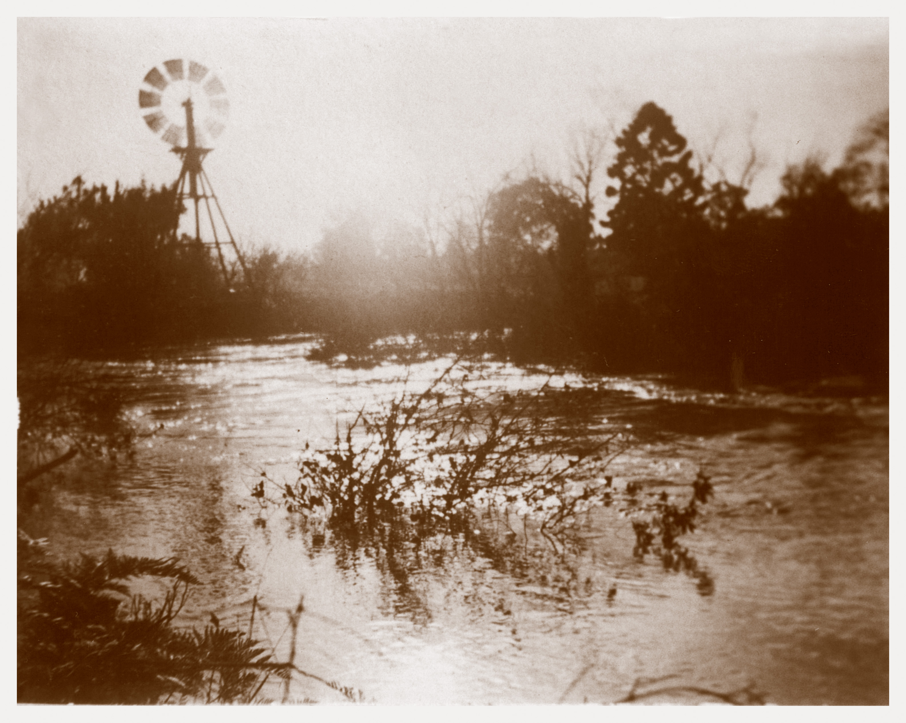
A Wragge photograph from the 1890s shows the river in flood and in 1996, a century later, another flood was captured in this video clip:

There is no doubt that Yan Yean was a visionary engineering project for an infant colony when it opened in 1857. Certainly Yan Yean water was an improvement on the old system of collecting water from the Yarra, upstream from the settlement, and carting it around the town in barrels.

Before the opening of the Yan Yean Reservoir on the Plenty River in 1857, Melbourne's water needs were met by primitive means
Before the opening of the Yan Yean Reservoir on the Plenty River in 1857, Melbourne’s water needs were met by primitive means

Visiting Australia in 1871, the English novelist Anthony Trollope, wrote of Melbourne’s water supply and stated, perhaps with some satire, that it “is supposed to be the most perfect water supply ever produced for the use of man. Ancient Rome and modern New York have been less blessed in this respect than is Melbourne with its Yan Yean. I do believe that the supply is almost as inexhaustible as it is described to be. But the method of bringing it into the city is not as yet by any means perfect… I will also add that the Yan Yean water is not pleasant to drink — a matter of comparatively small consideration in a town in which brandy is so plentiful.”

Anthony Trollope around the time of his visits to Australia, c1870s

I’ve heard tell that ultra-pure water (literally H²O) produced for use in the medical industry, has the texture of water without the taste of water, and in fact it can be quite dangerous to drink in quantity. Sounds weird doesn’t it? Generally, it is the mineral content in water that gives water the taste we assume it doesn’t have. The use of lead piping in early Melbourne, used to deliver water around the city streets, was probably one reason for Trollope’s reservations about the quality. Consumers at the time were even advised to run their taps to waste for a few minutes each morning in an attempt to lessen the dangers associated with lead piping.

Public warning which appeared on the reverse side of Melbourne water supply rate notices in the early 1860s

The “inexhaustible” supply described by Trollope all too soon also proved to be inadequate. Further diversions of streams into the Yan Yean system occurred and the 20th century saw the building of a series of new dams on many of the main rivers within casting distance of Melbourne. The last one was built on the Thomson River in west Gippsland within the memory of many people. When completed in 1983, the Thomson Reservoir was more than four times the capacity of Melbourne’s next largest reservoir and was supposed to drought proof Melbourne for all time.  Like Yan Yean and the other reservoirs, it was never going to be enough of course. Australia is a dry country. So dry in fact that here in Victoria a few years ago, with the much vaunted Thomson standing almost empty, the politicians went all to water in the face of an ongoing drought and in a robbing “Peter to pay Paul” exercise, built a pipe line to bring water from the Goulburn Valley across the divide to Melbourne. And if that was not enough, at the same time they ordered the building of a massive desalination plant on the Bass Coast near Wonthaggi.

A desalination plant was always going to be a dumb idea and the fact that regular rainfall since its opening has saved the desalination plant (or the pipe line for that matter) from being used is scarcely the point. When you have to start manufacturing water it’s clear to me that you have a population that is living beyond the ecological limits of the environment.

As Melbourne continues to expand into an ever enlarging megatropolis, it is our environment that always pays the price. The latest “Sustainable Cities Index”, a study that rates 50 of the world’s most important cities from 31 countries, taking into account social, economic and environmental considerations, ranks Melbourne 17th in environmental considerations. The same study however ranks Melbourne fifth for profitability and 8th in social factors. I can see a trend developing, can’t you?

In “Classing the Wool and Counting the Bales”, Winty Calder further described some of the environmental stresses that beleaguered the Plenty River at Yallambie in the second half of the 20th century:

Bill Bush would remember platypus in the Plenty River during the 1950s, but both the river and its flood plain were degraded as residential development proceeded. Frank Wright continued returning to Yallambie until the 1970s, by which time his early memories of the property were in sharp contrast to current reality. It had become “a jumble of new roads and dwellings, and the formerly lovely Plenty River (was) a yellow mess of pollution and dumped rubbish.” (Letter from Frank Wright to Olive Shann.) He would never forget that:

“about 1970 or ’71, I… looked sadly at the once pure and beautiful Plenty. The water was a turbid orange colour from the stirred up clay. Raw bulldozed rubble edged the waterway in places. Tin cans, old tyres and other dumpers’ rubbish littered the scene. No sewerage drains served the many dwellings along the banks. I don’t want to see the Plenty again.” (Frank Wright, “Recollections of the Plenty River”).

Soon after Frank’s last visit to that river, the water quality testing programme of the Melbourne and Metropolitan Board of Works confirmed his fears that the Plenty was so polluted it could no longer support aquatic life in its lower reaches. However, by then, a main sewer traversed the whole length of the river with branch sewers connected to it at various points.

Around the time Frank Wright wrote his epilogue of the Plenty River, a report from the Melbourne and Metropolitan Board of Works put forward the notion that by 1990 the then polluted river systems of Melbourne would be mended. In fact it claimed that the Yarra, Melbourne’s perennial “upside down river”, would be flowing by then like some sort of Perrier at Dights Falls in Collingwood. Or words to that effect.

Stereoview of children swimming in the Darebin Creek at Ivanhoe

It seems hard to believe now, but the Yarra River and its tributaries at Heidelberg, the Plenty River and Darebin Creek all had their swimming holes at one time, some with suburban beaches and pools, dug out surrounds and semi concreted sides rather like sea baths — that was before river pollution made them unfit or at least unfashionable for use.

Swimming Pool in the Plenty River at Greensborough, c1952

The remnants of a swimming pool on the Plenty River at Greensborough, a little upstream from Yallambie, are still visible and can be found just below the Main Road Bridge. The Greensborough pool was built as a “Susso” project in the Great Depression at a cost of £200 and was of cement and blue stone construction. It was opened in 1937 by the Mayor of Heidelberg, Councilor Robert Reid with demonstrations of swimming by leading swimmers of the day. It now makes a convenient platform for occasional anglers who would probably balk at the idea of getting their feet wet in the sometimes murky water.

Fishermen casting into the former swimming pool on the Plenty River at Greensborough, February, 2015

A very good swimming beach of sand at Sills Bend in Heidelberg was still being risked by hardy souls when I was a boy but reduced and changing river flows have  affected stream form and that beach consists now mainly of silt and clay when last I visited. I believe there was formerly a camping spot used by the Scouts located just down river from Sills Bend at Bulleen near what is believed to be today one of the most polluted ground locations in Heidelberg — namely the old gasometers site. Camping there was probably never a very good idea. Swimming in the Yarra these days is limited largely to around Warrandyte and to further upstream.

Against all odds and in the face of continued suburban expansion, by the 1990s Melbourne’s rivers were indeed considerably cleaner than from the time when Frank Wright wrote about the Plenty. Still not quite the promised Perrier but things had improved by 1997 to the extent that the local newspaper was able to report that platypus were once again occupying the Plenty River at Yallambie, in the vicinity of the Lower Plenty Rd Bridge. The following year a fishing event was organized for the river codenamed “Catch a Carp Day”. It was intended to reduce the numbers of these introduced European fish in the Plenty River, the correct assumption being that the species was in competition with the native aquatic wildlife.

"Catch a Carp Day" fishing event on the Plenty River at Yallambie, October, 1998
“Catch a Carp Day” fishing event on the Plenty River at Yallambie, October, 1998

In January this year it was reported that a 20 year old platypus was found in the Plenty River during a spring survey in 2014 and that, “a breeding population exists at least as far downstream as the mouth of the Plenty River, about 15 kilometres from downtown Melbourne”. (The iconic Platypus is a peculiar animal. A semiaquatic, egg laying, mammal it is the sole living representative of the family Ornithorhynchidae, in the genus Ornithorhynchus (literally bird billed). When stuffed examples were sent for study from Australia to Britain at the end of the 18th century, outraged scholars believed they were the victims of an attempted elaborate antipodean hoax. They infamously tried to remove the “stitching” on the platypus bill that they were sure had been employed in the forgery and the marks of the scissors can still be seen on the specimen on display today in the British Museum of Natural History.)

First published illustration of a Platypus: George Shaw, The Naturalist's Miscellany, 1799
First published illustration of a Platypus: George Shaw, The Naturalist’s Miscellany, 1799

In the 19th century it was not unknown for platypus pelts  and the furs of other rare native species to be turned into rugs and coats like some sort of Australian “One Hundred and One Dalmatians”. A pity nobody stripped their crinoline for PeTA in the 19th century. The Platypus is of course a protected species these days but it remains at risk from pollutants in rivers and the practice of illegal netting. A local newspaper story last month warned about illegal fishing practices and mentioned that two platypuses had recently been found dead in the Yarra River near Laughing Waters Rd, Eltham.

Platypus pelt rug from Alstonville, NSW, (Power House Museum) and Thylacine skin buggy rug from Upper Blessington area, Tasmania, (Tasmanian Museum and Art Gallery)

March 1st, is designated “Clean Up Australia Day” 2015, a day when many socially conscious Australians are getting out into the community to clean up the environment. There is a group meeting today in Yallambie Park where no doubt much good work will be done along the environs of the Plenty River, clearing the rubbish washed into the river by overnight rain. “Clean Up Australia Day” is a great Australian idea, the concept of which has spread to nations all around the world, but it is just one day of the 365¼ days in a year.

People love water features near their homes, be they bayside, a natural stream running through parkland, or artificial lakes in the manner of Yallambie’s, “Cascades” and “Streeton Views” housing estates.  However, while storm water continues to empty into the suburban river system, every poisonous cigarette butt dropped from a car window, every oil spill that goes onto the road and the proceeds of every one of man’s best friends who ever uses a Ned Flander’s nature strip as a make shift dunny, all of it eventually ends up in one of our rivers or lake features. From there it makes its inexorable way to the Bay and thence to the oceans. After the oceans though there’s no where else to go on this “Pale Blue Dot”. That is the “Wall-e” reality of our world.

Made in Japan and inspired by the Australian platypus, perhaps. Duck bill designer pet muzzles for the Japanese pet owner who has everything.

The Terra nullius dream

“I acknowledge the traditional owners of the land on which we are meeting.” How often have you heard these words spoken before a public event? They are de rigueur at my son’s school at every assembly and public gathering but when I asked him what he could tell me about Eddie Mabo’s fishing rods he looked at me with bewilderment. As another Australia Day dawns and we once again remember the time in 1788 when the Indigenous people of Sydney Cove watched the sails of the convict ships enter Sydney Harbour, and muttered “Crikey” to themselves, what do those words really mean and how much of what we say is just lip service? The Yallambie days of yore that I have been writing about in these posts was not of course the first history of our district. There is another, earlier history dating back thousands of years, knowledge of which W. E. H. Stanner once described as “the great Australian silence”.

A 19th century engraving of an indigenous Australian encampment, representing the indigenous mode of life in the cooler parts of Australia

When the land that was to become the suburb of Yallambie was sold at public auction as Portion 8 at the first Crown land sales in 1838 it was assumed the land belonged to a Queen, then in the first year of her reign, sitting on a throne on the other side of the world and that it was hers by right to dispose of. It took a split decision by the best legal minds in Australia sitting on the High Court of Australia in 1992 to finally change that perception. I don’t know enough about the subject to write about it authoritatively but it seems appropriate on this day to write in a general way about the Wurundjeri, the tribe of indigenous Australians who before European settlement once occupied much of the present location of Melbourne.

The explorer, geologist and anthropologist, Alfred Howitt, son of William Howitt. Picture State Library of Victoria.

According to the explorer and anthropologist Alfred Howitt, who with his father William visited “Yallambee” in October 1852, the Wurundjeri tribal territory was generally agreed to be all the area drained by the Yarra/Plenty River basins. It has been written elsewhere that at Yallambie the Wurundjeri occupied a more or less permanent summer camp, above a deep pool in the Plenty River that could be relied upon to never run dry even at times of the worst drought: “At that time Aborigines had a permanent camp above that long, straight, deep stretch of river below Tarcoola Drive”.

A "deep pool" on the Plenty River at Yallambie, January, 2015
A “deep pool” on the Plenty River at Yallambie, January, 2015

Archaeological studies by Banyule City Council and the MMBW have identified some evidence of pre contact civilization along the lower reaches of the Plenty River, from scarred trees to artefact scatters and possible mound sites. It is a fragile jigsaw puzzle that continuing research will add to although sometimes that puzzle can take an unexpected turn. Some years ago a newspaper reported that a skeleton had been found in a Montmorency backyard, just upstream from Yallambie and on the other side of the river. The police were called, it being believed that evidence had been found of our very own Montmorency, “Midsomer Murders”. They went away soon afterward when it became apparent that the skeleton was of Indigenous origin and of great age, proof if proof be needed of the long occupation of the area by native people.

Banyule City Council sign posting on the banks of the Plenty River, Yallambie Park, reads: "Heartland of the Wurundjeri william".
Banyule City Council sign posting on the banks of the Plenty River, Yallambie Park, reads: “Heartland of the Wurundjeri willam”.

A few years ago at the suggestion of my wife and I, Banyule Council installed a sign on the horseshoe bend of the Plenty River at Yallambie marking the presence of the first Australians in this locality. It’s a fine looking piece of sculpture shaped a bit like a native shield propped between two logs. I’ve heard it suggested that horse shoe loops on a river were good hunting grounds for Indigenous people. They could chase game into the bend and corner their quarry on steep banks. Perhaps the sign is a little inappropriately placed however and might have been better located upstream, near the permanent waterhole that the Indigenous people are said to have occupied as a camp. A second sign describing the Colonial history of the Wragge and Bakewell farms on the river flat would have been a better option for the location chosen. But that’s another story.

The Station Plenty, (Yallambie) view X by Edward La Trobe Bateman 1853-1856. Trees and creek.
The Station Plenty, (Yallambie) view X by Edward La Trobe Bateman 1853-1856. Trees and creek. The waterhole where Indigenous people are said to have occupied a camp.
Plenty River at Yallambie, January, 2015

The story of John Batman’s infamous 1835 “Treaty” with the Wurundjeri people is well known. Teachers told us about it in school but if you were too busy considering the aerodynamic capabilities of the latest folded piece of exam paper, I would recommend Rex Harcourt’s enormously interesting book “Southern Invasion, Northern Conquest” (Golden Point Press, 2001). It contains what I think is the clearest account in print of the circumstances surrounding the Treaty and the events leading up to it. The rejection of the Treaty by Governor Richard Bourke implemented the doctrine of Terra nullius upon which British possession of Australia until Mabo became based.

The infamous "Batman Treaty"
The infamous “Batman Treaty”

The location of the signing of Batman’s “Treaty” remains unclear. Most probably it was on the Merri Creek downstream from Rushall Station where High Street now climbs the artificial embankment to Northcote. I’ve walked there along the Merri Creek Trail with Harcourt’s book in hand and that’s my favourite for it matches John Batman’s description very nicely. However, there have been several other sites suggested including the intriguing theory put forward by H. G. Turner in his “History of Colonial Victoria” that the Treaty was signed on the Plenty River at Greensborough, just a little upstream from Yallambie. The eight Wurundjeri elders who placed their crosses on Batman’s ludicrous document on that day in 1835 almost certainly had no idea what they were signing. They were not the owners of the land that Batman and his Port Phillip Association were attempting to purchase. The land was held in common by the Tribe and was not the property of any one man to dispose of. Possibly they thought they were participating in a gift giving ceremony of friendship. With friends like these, who needs enemies?

John Batman portrait by William Beckworth McInnes (City of Melbourne Collection )

The world that the settlers brought to the Plenty River and the place that Indigenous people soon occupied in it is illustrated in the following account of the gentleman squatter Captain John Harrison on the Plenty River at Yan Yean. Written by his son in 1927 it tells of contact with Indigenous people in 1837-1843 but it might equally well have described the world of Edward Willis and John and Robert Bakewell when they occupied their land on the lower reaches of the Plenty River. According to Isabel Ellender who reproduced this description in her 1989 report “The Plenty Valley Corridor”, Harrison “was typical of many of the early settlers encountered by the Aborigines of the Plenty Valley in the 1830s”.

“The blacks in the district (the Plenty Valley) belonged to the Yarra Yarra tribe and were considered rather dangerous at first. But only on two occasions do I remember our having an alarm through blacks. The first time, hundreds of them surrounded the house, the quadrangle was full of them… the blacks evidently thought only women and children were at home, for presently they became very cheeky, knocking at the doors with their waddies and sticks. My father… suddenly rushed out on them with his gun in his hand; and they were evidently so surprised at the sight of him that they disappeared in a most miraculous manner… But we could hear a great jabbering going on down at the potato patch… and there, we could see some of the lubras digging up potatoes with their yam sticks. These were always carried about by them and were six or seven feet long, and about thick as a man’s wrist, with a sharp point at one end.”

Bear's Castle, Yan Yean, from a 1905 postcard.
Bear’s Castle, Yan Yean, from a 1905 postcard.

Near the head waters of the Plenty River lies a curious colonial building historically known as “Bear’s Castle”. I can remember my late father telling me of it when I was a wide eyed schoolboy. In his role as an inspector for the MMBW, my father was responsible for the water supply of a wide area, at one time ranging from the Heidelberg depot to the Yan Yean Reservoir. Bear’s Castle he told me had been built in the “olden days” to defend farmer Bear’s farm from marauding tribes. I don’t think he quite believed the legend himself and more than likely the “Castle” was built as a garden “folly” in the style of the English Picturesque. But it makes a good story all the same. It’s not easy to get permission to visit the “Castle” today as it lies within the catchment of the Yan Yean Reservoir. I last saw it nearly two decades ago. Bear’s farm itself lies somewhere out in the middle of the reservoir, under about 30,000 megalitres of water.

The writer at Bear's Castle, 1997
A hairy bear at Bear’s Castle: the writer at Bear’s folly in 1997

The Wragge family of Yallambie are known to have had many dealings with Indigenous people, if not at Yallambie, then at their Riverina properties. The Wragge’s are believed to have collected several Stone Age weapons and tools, Indigenous artifacts that had been ploughed up in their farm fields. Winty Calder, writing in “Classing the Wool and Counting the Bales – The Wragges of Tulla and Yallambie” (Jimaringle Publications, 1997) said of the native people of the Riverina that: “The bond between Aborigines and their country has never been fully understood by white people. The tact and friendliness of Charles Sturt, when he explored the Murray in 1829-1830, probably prevented trouble along the river above its junction with the Darling. People met by Joseph Hawdon south of the Murray (between Echuca and the Loddon River) in 1838, when there had been reports of native hostility, showed mixed reactions to the intruders. There was curiosity, alarm and astonishment. Some were not welcoming, others attempted to pilfer the explorers’ goods. In the early 1840s, Edward Curr rode over country along the lower Edward, Wakool and Niemur Rivers, which was unoccupied by Europeans, without any trouble from Aborigines, but he stressed the fact that he was careful, especially with the Moira blacks on the northern side of the river. Less than forty years later a new Aboriginal generation could no longer oppose the advance of white settlers. Numbers had decreased steadily as they fell victim to diseases caught from the whites, and as they were occasionally shot. They largely abandoned their health-giving, traditional hunting and fishing to hang about the settlers’ huts, miserable and underfed, hoping for hand-outs from the newcomers. The pressure of white occupation resulted in listlessness among many of the Aborigines, and loss of interest in life”. Later still, many Indigenous people worked on the Wragge sheep stations as labourers, roustabouts and shearers, employees of white men on land that their forefathers had occupied for uncounted generations. Call us eccentric but where other couples would have chosen to lounge on a Queensland beach sipping gin and tonics, my wife and I spent our honeymoon plodding through paddocks in the Riverina in pursuit of this history visiting the old Wragge homesteads. At one of them I remember the modern day homesteader (not a Wragge descendant) showed us openings in the doors and walls of the original, free standing dairy, apertures which she claimed were rifle slopes, a sure sign of the dangers encountered by the original settlers of the district. I thought they looked like ventilation holes.

Phillippa Sutherland recently produced a very nice looking booklet for the Banyule Council called: “Banyule, Heartland of the Wurundjeri Willam”. It is freely available from the Council service centres and contains this final, delightful story of the Wurundjeri dream time, adapted by Sutherland from S. Wieneke, ‘When the Wattle Blooms Again’.

Frances Derham, 1894-1987

Once, the water of Birrarung (Yarra River – ‘river of mists’) was locked in the mountains. This great expanse of water was called Moorool (‘great water’). It was so large that the Woiworung had little hunting ground. This contrasted with the Wathaurung’s and Bunurong’s hunting ground, the flat which is now Port Phillip Bay. Mo-yarra (‘slow and fast running’) was the headman of the Woiworung. He decided to free the country of the water and cut a channel through the hills, in a southerly direction, until he reached Koo-wee-rup (Western Port). However, only a little water followed him and the channel gradually closed up. At a later time, the headman of the tribe was Bar-wool. He remembered Mo-Yarra’s attempt to free the land. He knew that mo-Yarra still lived on the swamps beside Koo-we-rup. Each winter he saw the hilltops covered with feather-down which Mo-Yarra plucked from the water birds sheltering on the swamps. Bar-wool resolved to free the land. He cut a channel up the valley with his stone axe, but was stopped by Baw-baw, the mountain. He cut northwards, but was stopped by Donna Buang and his brothers. Then he cut westwards, through to the hills to Warr-an-dyte. There he met Yan-yan, another Woiworung. Yan-yan was busy cutting a channel for the Plenty River in order to drain his homeland of Morang. They joined forces and the waters of Moorool and Morang became Moo-rool-bark (‘the place where the wide waters were’). They continued their work, and reached Warringal (Heidelberg-Templestowe flats – ‘dingo-jump-up’). There they rested while the waters formed another Moorool. When Bar-wool and Yan-yan set to work again they had to go much slower because the ground was harder and they were using too many stone axes. They cut a narrow, twisting track between the Darebin and Merri Creeks, looking for softer ground. At last they reached Port Phillip. The waters of Moorool and Morang rushed out. Woiworung country was freed from water, but Port Phillip was inundated.” A charming story that in an uncanny way echoes what we know of the landscape from the geological record. The course of the Plenty River was changed 8000 years ago when volcanic eruptions in the west deposited a basalt flow that the river was then forced to cut a path through, creating Greensborough’s Plenty Gorge. The Plenty River at Yallambie marks the end of this basalt plain. The river bed at Yallambie and downstream until its confluence with the Yarra River in View Bank, follows the original course of the river across older, sedimentary beds. In prehistoric times when water levels were lower, the first Australians saw Port Phillip Bay as a game filled, grassy plain with the prehistoric course of the Yarra River cutting a route across it to the sea. I am told that the ancient river bed is still there, underwater somewhere at the bottom of the Bay. It has been modified to form the shipping channel so recently and so controversially deepened and is used by vessels entering the relatively shallow waters of Port Phillip enroute to the Port of Melbourne. So on this Australia Day, if you get the opportunity to take a dip with your inflatable kangaroo in the “True Blue” waters of Port Phillip or to play a game of beach cricket on some Peninsula shore line, remember for a moment a time before 1788 and 1835. A time when the first Australians hunted real kangaroos out on the grassy plains of Port Phillip where holidaying Aussie fishermen now pull in flathead and snapper. Those grassy plains are long gone now, as are the native camps of the plains and the Plenty River. They exist now only in a time of Dreams.

Frances Derham
Frances Derham, 1894-1987