“But the plans were on display…”
“On display? I eventually had to go down to the cellar to find them.”
“That’s the display department.”
“With a flashlight.”
“Ah, well, the lights had probably gone.”
“So had the stairs.”
“But look, you found the notice, didn’t you?”
“Yes,” said Arthur, “yes I did. It was on display in the bottom of a locked filing cabinet stuck in a disused lavatory with a sign on the door saying Beware of the Leopard.”
Douglas Adams
Thus Arthur Dent learned at the start of The Hitchhiker’s Guide to the Galaxy of the plans to destroy his home for a new road.
“It’s a bypass. You’ve got to build bypasses.”
This week the State Government through the guise of its North East Link Authority dropped a bombshell. It came right out of left field and landed in the solar plexus of the Yallambie community, catching all and sundry totally by surprise. As I listened to the news of this exploding shell broadcast on early Monday morning radio, I couldn’t help but think I had been weirdly trapped inside a scene from the chapters of a Douglas Adams’ science fiction farce, but this was no laughing matter. Secret proposals have been going on behind closed doors at North East Link and while nobody has been looking, somebody just moved the goal posts.
The North East Link Authority, charged with finding a route for the missing piece in Melbourne’s road system, had just announced a choice of four alternative routes to fill the void in that network. Wikipedia has long listed three of them, an eastern option from the Western Ring Rd to East Link via Kangaroo Ground and Chirnside Park, (corridor D); a central option from the Ring Rd to Eastlink via Eltham and Warrandyte, (corridor C) and a western option from the Ring Rd to the Eastern Freeway at Bulleen via Watsonia and Viewbank, (corridor A). But a fourth, previously un-thought of route has unexpectedly been thrown into the mix by the lads at North East Link. Their so called corridor B. The B is for bomb.
Yallambie.
Kaboom.
In essence corridor B is an afterthought. Maybe even a Furphy. A bad and cynical attempt to wrong foot opposition to an already unpopular road by dividing discussion. If built this unexpected option would be a disaster for Watsonia and Yallambie and would completely and utterly destroy the Lower Plenty township to boot.
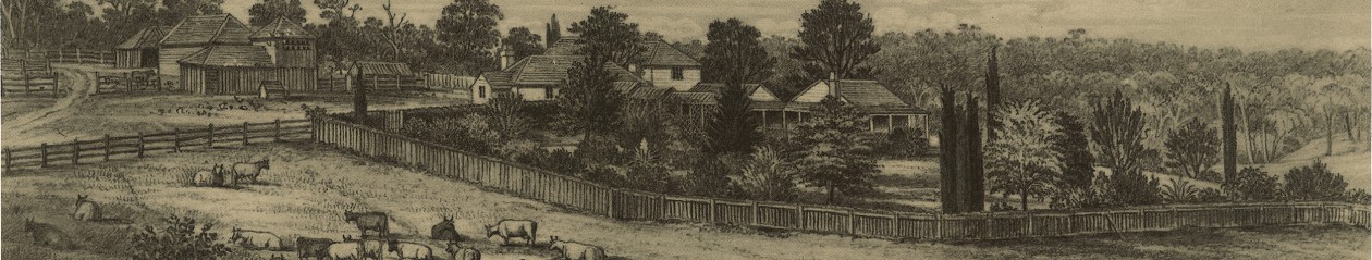
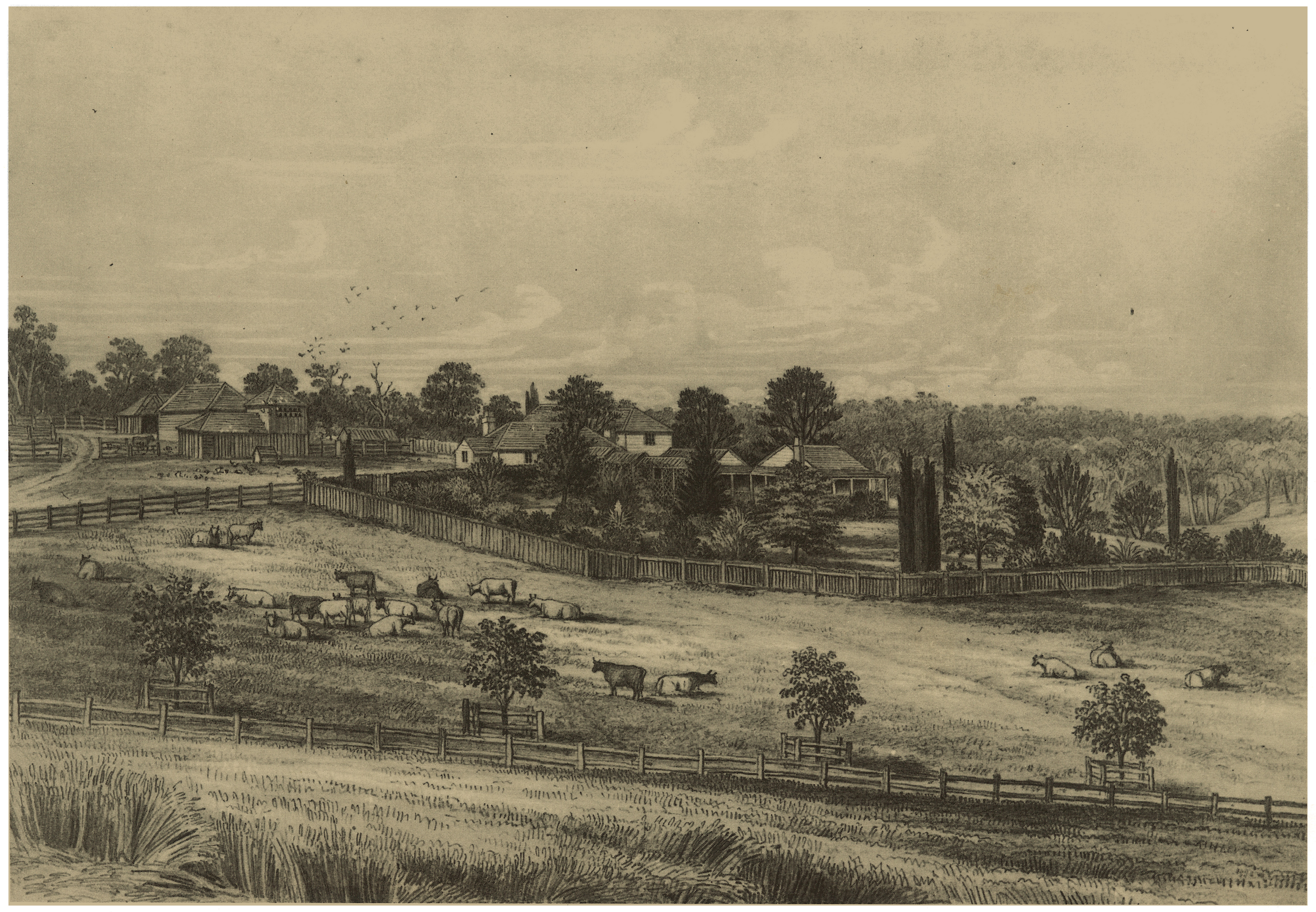
The Station Plenty, (Yallambie) view I by Edward La Trobe Bateman. Source: State Library of VictoriaAn imagined North East Link connection at Yallambie seen from across the River at Lower Plenty. The reality would certainly be far worse.
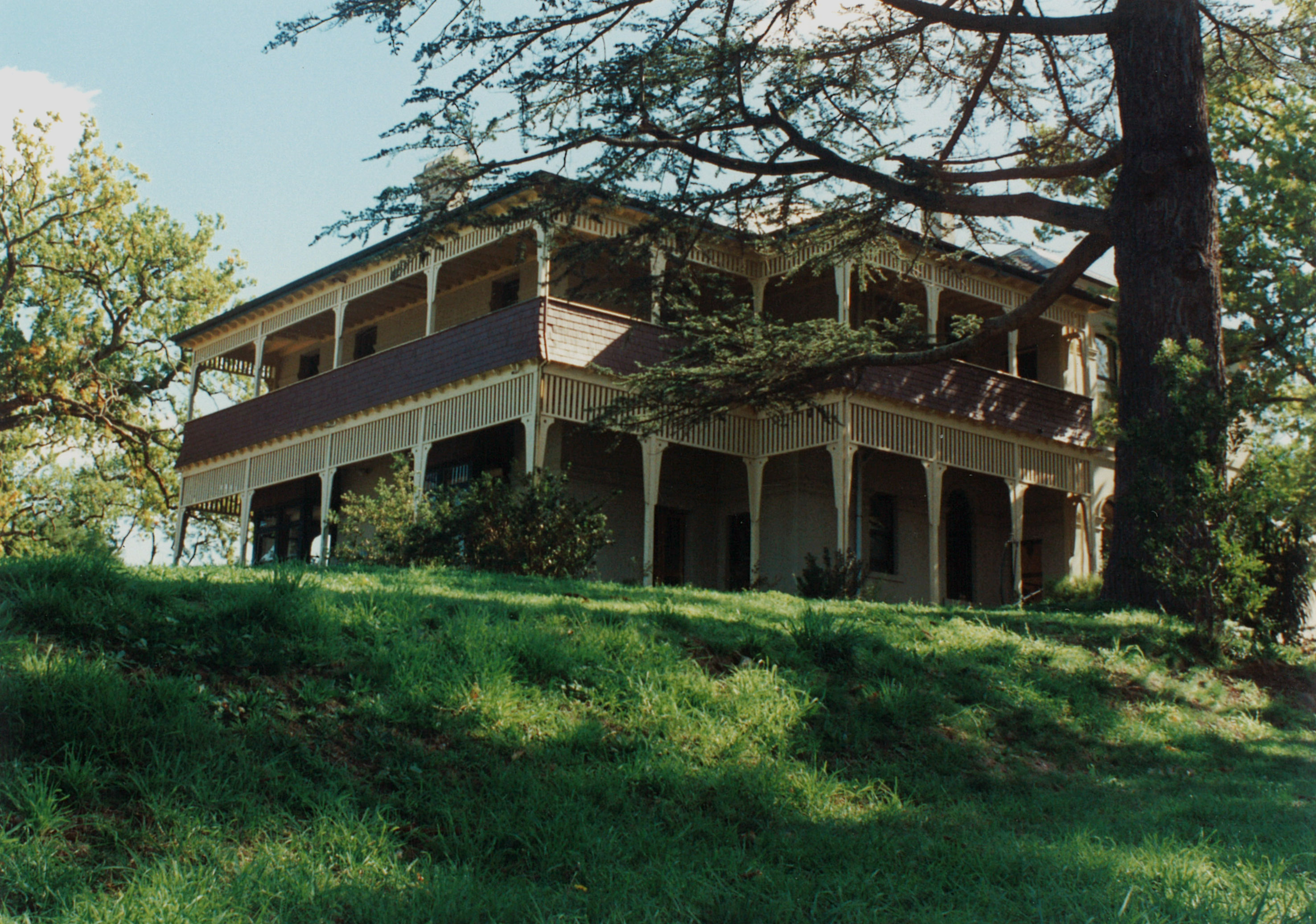
The unique landscape at Yallambie and Lower Plenty has remained largely unchanged since the 1840s and was recognized and classified nearly two decades ago by the National Trust. Who could possibly think the idea of exiting a tunnel over this landscape and filling it with a spaghetti of connecting roads could be a good idea in this day and age? The corridor B proposal aims to smash a gaping hole into all of it (literally) by taking a route off the Greensborough Highway through Watsonia and the northern borders of Yallambie, almost certainly compulsorily acquiring and demolishing the homes of countless families in the process, before plunging underground along the existing electrical easement and spewing out of the ridge directly in front of the Yallambie Homestead. If that old and fragile building does not fall down from the vibrations during the underground blasting process of building the tunnels, then the combined effects of over a hundred thousand vehicles a day travelling on it will.
Yallambie Homestead photographed in 1995.Yallambie Tennis Club, June, 2015.
There are practical considerations for the builders’ of these roads not tunneling under rivers so the proposed corridor B route would presumably follow an elevated flyway across the Yallambie Flats, obliterating the existing soccer ground if not the tennis club in the process before crossing the Plenty River opposite the Lower Plenty Hotel and ripping the heart out of the Lower Plenty township itself.
Soccer ground, Yallambie Park, homestead on the hill, November 2014Lower Plenty Hotel terrace. (Source: David Sarkies, True Local).
You can forget ever having another drink at the Lower Plenty Hotel while marveling at its unique bush land setting.
Lower Plenty, June, 2017.
You can kiss goodbye the Heidelberg Golf Course and the adjacent green wedge of the historic Edward Willis landscape. This proposal is an utter disgrace and would be a catastrophe for this area.
And just for good measure, for those who worry about such things, you can forget about selling your real estate right now. Your house has just become unsellable overnight by the mere mention of this road. So much for Yallambie as the 6th most “in demand suburb” in Australia.
Looking towards Yallambie from Lower Plenty during the farming era
What could they have been thinking? Who are the Vogons who dream up these ideas without a by your leave and then try to back pedal them as a realistic alternative to an existing transport problem?
But no, that’s not the end of it. The road they call corridor B would then travel through the back of Lower Plenty for an unspecified length before heading back underground again only to emerge and bash a path through the edge of Warrandyte and Donvale at Reynolds Road in order to meet up with Eastlink. How many communities do these planners plan to destroy along their merry way?
I was a child growing up in Rosanna when the battle lines were first drawn up in the 1970s to stop construction of what was then known as the F18 Freeway. That road aimed to carve a surface route through the back streets of the former City of Heidelberg. I might have been a kid but I remember the adults around me mobilising public opinion, attending protest rallies and vowing to lie down in front of the bulldozers if it came to the point. The years have moved on and those remembered adults of my youth are now all dead but still the fight marches on and into another generation.
I’ve been writing regularly in these pages for three years about the merits of this very special corner of the world. My writing has been an attempt to draw attention to Yallambie, its natural beauty, its historic stories and the fantastic lifestyle to be enjoyed while living on the lower reaches of the nearby precious Plenty River. I’ve mentioned in these pages the possibility of a North East Link more than once, the last occasion in my May post of this year. In my wildest dreams though I never imagined for one moment that this hot potato would fall out of the fire so close to home and that the decision makers would pull this one on us like a Yallambie rabbit out of a hat. It might be sleight of hand but they’re not fooling anyone.
National Trust map showing the extent of their 1998 classification at Yallambie. The proposed North East Link freeway would emerge from a tunnel under the high voltage transmission line easement on the western boundary of the classification and cross National Trust classified land to Lower Plenty on the eastern bank of the Plenty.
Let’s call a spade a spade and call this proposal for what it is. An absolute turkey that has only been suggested now to deflect attention because of the real fight the government knows it will have on its hands with the other routes. The other corridors have been on the cards for many, many years and local groups opposed to them are well organised and ready for the fight. Before last week this had never even been suggested as an option for Yallambie and the local communities in Yallambie, Lower Plenty and elsewhere have been caught completely unprepared. It is insulting that residents have had to find out about this proposal from the newspapers and radio news. Yallambie is a small suburb and we have always had a small voice, but what consideration has been made for the people living here and elsewhere and for the birds and wild life, the historic landscape and the special bushland setting? What of beauty and nature and all those things that make up life in one of the best living environments in the city of Melbourne?
North East Link proposes to destroy all of that unless we make ourselves heard.
Stand up and have your say now. If we leave this until it is too late it will be no use complaining when you wake up one day to find yourself living in a car yard.
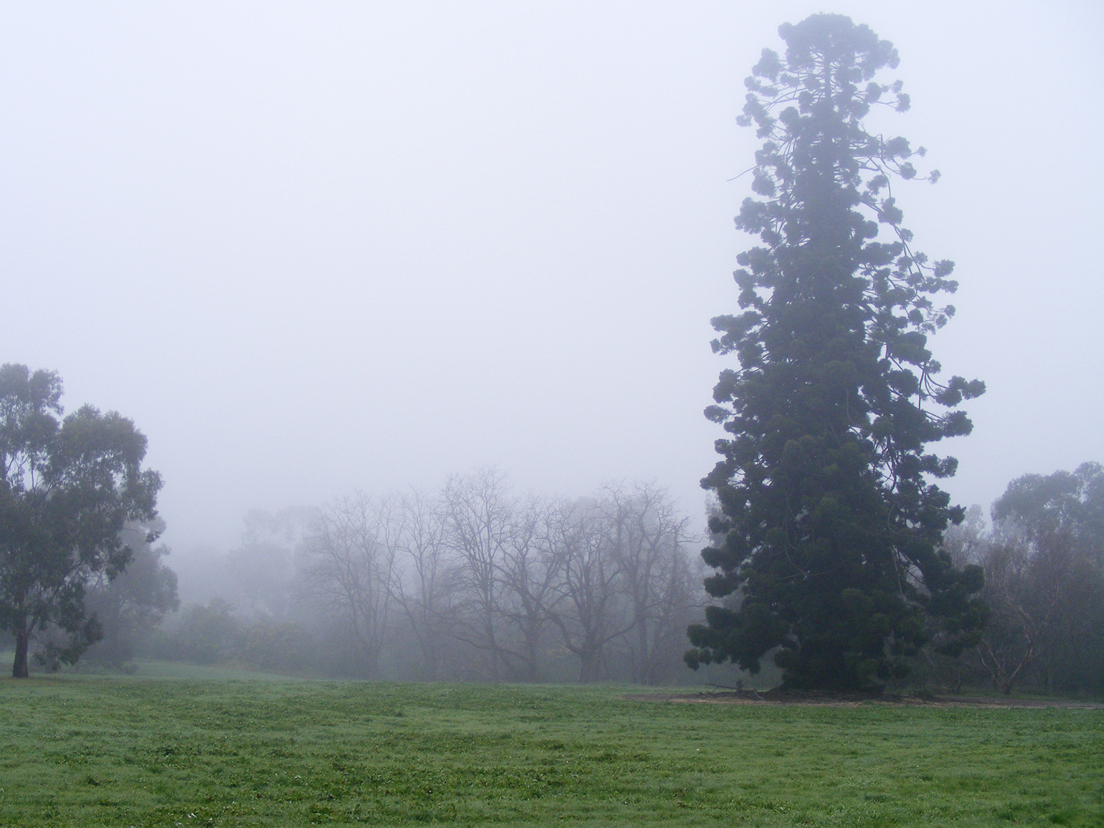
Misty morning with Hoop pine at Yallambie, August, 2014
This morning I woke before the sunrise and lay in bed worrying while I listened to the dawn chorus of singing birds. Would the bell like sounds of the King Parrots soon be replaced by the noise of a hundred thousand vehicles a day spewing from a hole in the ground like the legions of Mordor? As if in answer to my question a lone kookaburra joined in with a tune, the ensuing laughter of its call ringing loudly in my ears. Maybe the kookaburra had been reading those newspapers. The North East Link Authority’s Monday announcement was driven off the front page the next day by a story about the Opposition Leader, a crayfish and the company he keeps. It’s good to keep these things in perspective.
Luckily for Arthur Dent, he was able to hitchhike a lift from a passing spaceship to escape the destruction of his hometown by the bulldozers. The rest of us are not so lucky. The decisions made on Melbourne’s road network in the near future will effect this city and the people living in it for generations to come. The destruction of communities in order to build these roads will look pretty stupid when Peak Oil has stopped vehicles in their tracks and left nothing behind other than a hole in the ground and an inter-generational debt with a fiscal and social implication of almost unimaginable proportions.
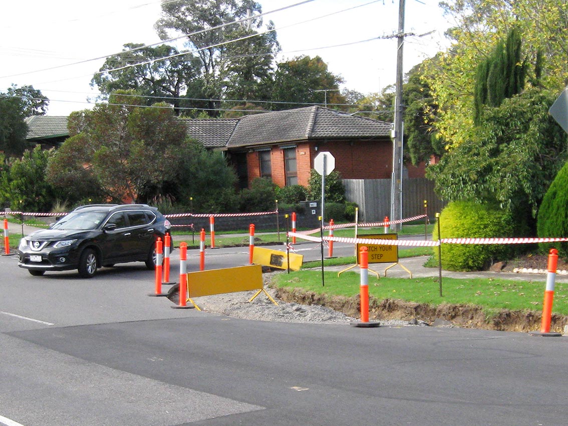
It’s a bit of a cliché, but the incongruous sight of men leaning on shovels around a road sign announcing the apparent falsehood, “men at work”, is one we are all familiar with. In Tarcoola Drive, Yallambie at the start of April one such sign went up on the nature strip near the corner. It read “roadwork ahead”, a precursor to sawn lines being cut into the road surface in front of it, then – nothing. It has been like that for a month, a road hazard if not actual roadwork, evidence that somebody at the road depot at least has a sense of humour. There the sign has stood forgotten, oblivious to traffic and to all intents and purposes seemingly abandoned. Eventually a motorist missing the corner drove right on over it, bending it into a shape like banana or a boomerang made by an First Nations Aussie on a bad day.
“Road work” at the Tarcoola Drive/Yallambie Road intersection, May, 2017.
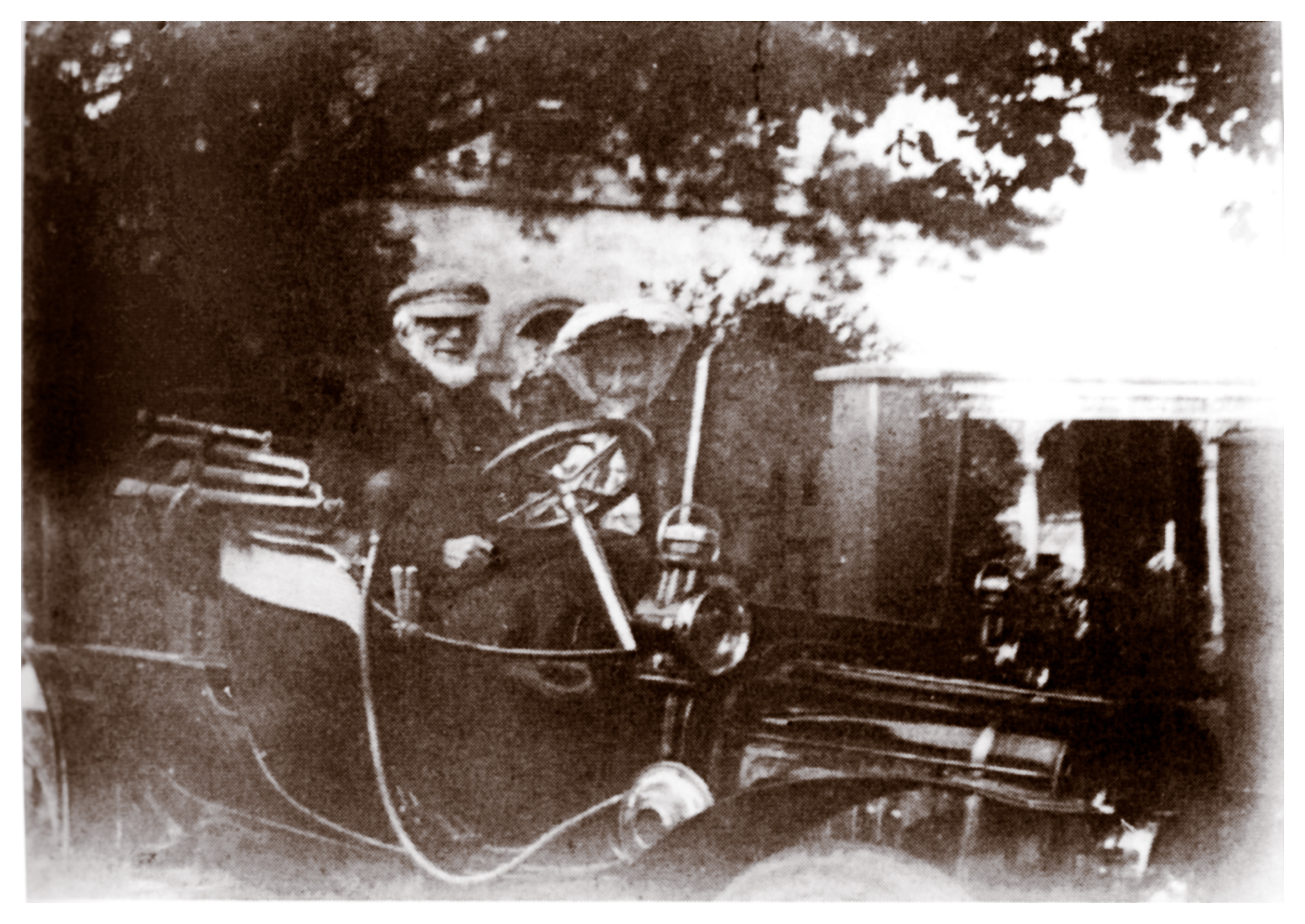
The intention I’m told is to build new kerb “outstands” on the corner. These projecting kerbs are intended to reduce the speeds of vehicles entering and exiting Tarcoola Drive by making the turn disproportionately more dangerous. Yallambie’s Thomas Wragge, who owned one of the very first motor cars in the Heidelberg district, is said to have preferred a horse and cart. He may have been right.
Thomas and Sarah Ann Wragge in a Brazier outside Yallambie Homestead shortly before the death of Thomas in 1910. (Source: Bill Bush collection)
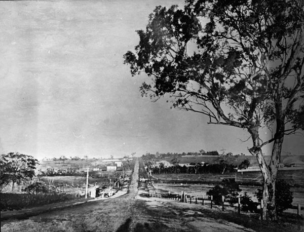
Roads were an early priority of this area and it has been argued by D S Garden that the creation of the Heidelberg Road Trust in 1841 constituted the earliest known form of local government within the Port Phillip District. The road to Heidelberg had been formed in 1839 and was known initially as the “Great Heidelberg Road”. It was laid out by the surveyor J Townsend who followed a line that was more or less parallel to the Yarra River.
Lower Plenty Road in Rosanna, 1914 looking south west towards the Upper Heidelberg Road intersection. The approach to Yallambie was behind the photographer of this picture. (Source: Heidelberg Historical Society image).Junction of Lower Heidelberg Road and Banksia Street in Heidelberg, 1896. The recreation hall owned by Yallambie’s Thomas Wragge is in the centre of the picture. (Source: Heidelberg Historical Society image).
I picture Townsend in those far off days whistling the highs and lows of “The Bonnie Banks of Loch Lomond” as he surveyed his route, the design splitting Heidelberg Road into two paths after the Darebin Creek ford. His Upper Heidelberg Road, known initially as the Nillumbik Road, ran along the top of the ridge while the Lower Heidelberg Road, first called the Mount Eagle Road, followed the valley contours.
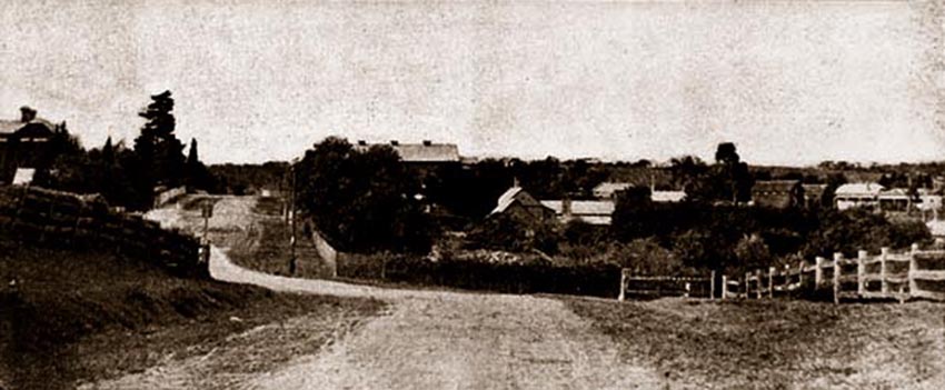
The Heidelberg Road commanded regular traffic from its inception. The route beyond to the Diamond Valley and Lower Plenty initially led to a ford over the Plenty River near what is now Martins Lane. Although shorter this route was discarded in 1840 in favour of the current line which was considered easier. William Greig, who as recounted previously farmed at Yallambie in that year, used this way regularly to visit town. That was until the early perilous condition of its surface sent his pony lame. Richard Howitt meanwhile, who lived on the Heidelberg Road at Alphington and who we remember for his visit to his Bakewell brothers in law at Yallambee in mid-1842, was equally unimpressed.
A beautiful town is Melbourne,
All by the Yarra’s side;
Its streets are wide, its streets are deep –
They are both deep and wide
Escaping from one quagmire,
There’s room enough for more;
Such a beautiful town as Melbourne
Was never seen before…
(Richard Howitt, Impressions of Australia Felix, p299)
One of the first tasks of the Heidelberg Road Trust then was to macadamise the road surface, a process that was commenced in 1842 and which was to introduce a technology which had not long been developed in Britain. The metal for the project came from a bluestone quarry at Alphington on the west bank of the Darebin Creek. As the colony emerged from the economic stupor of the 1840s, visitors to the Heidelberg district were astonished by the experience of travelling on a luxury road that boasted an incredible macadamized surface, the first in the Port Phillip District. In March, 1848, Bishop Perry wrote after travelling on this road that:
“Yesterday we drove to Heidelberg, which is the most settled part of the country. The distance from Melbourne is about eight miles, and the road is the only made road in the colony… Here and there we went along, were neatly piled up heaps of broken stone, ready for mending the road, just as you see in England; and at places we found men at work with shovels levelling, filling up holes etc.”
Almost a decade later in 1857, an attempt was made to reform the Heidelberg Road Trust by declaring the district a municipality. It failed after a petition opposing the move, led by the leading gentry of the region, was delivered to the government. Yallambee’s Bakewell brothers must have been getting ready for their return to England when they signed but all the same, their names appear there near the top of the parchment alongside such luminaries as Hawdon of Banyule, Martin of Viewbank, McArthur of Chartresville and what amounts to a mid-19th century virtual who’s who of the Heidelberg district. It appears there had been some disagreement over which part of the Heidelberg Road would most benefit from spending of the available road finances. The Bakewells, preoccupied with their return to England, possibly believed no money should be spent on it at all.
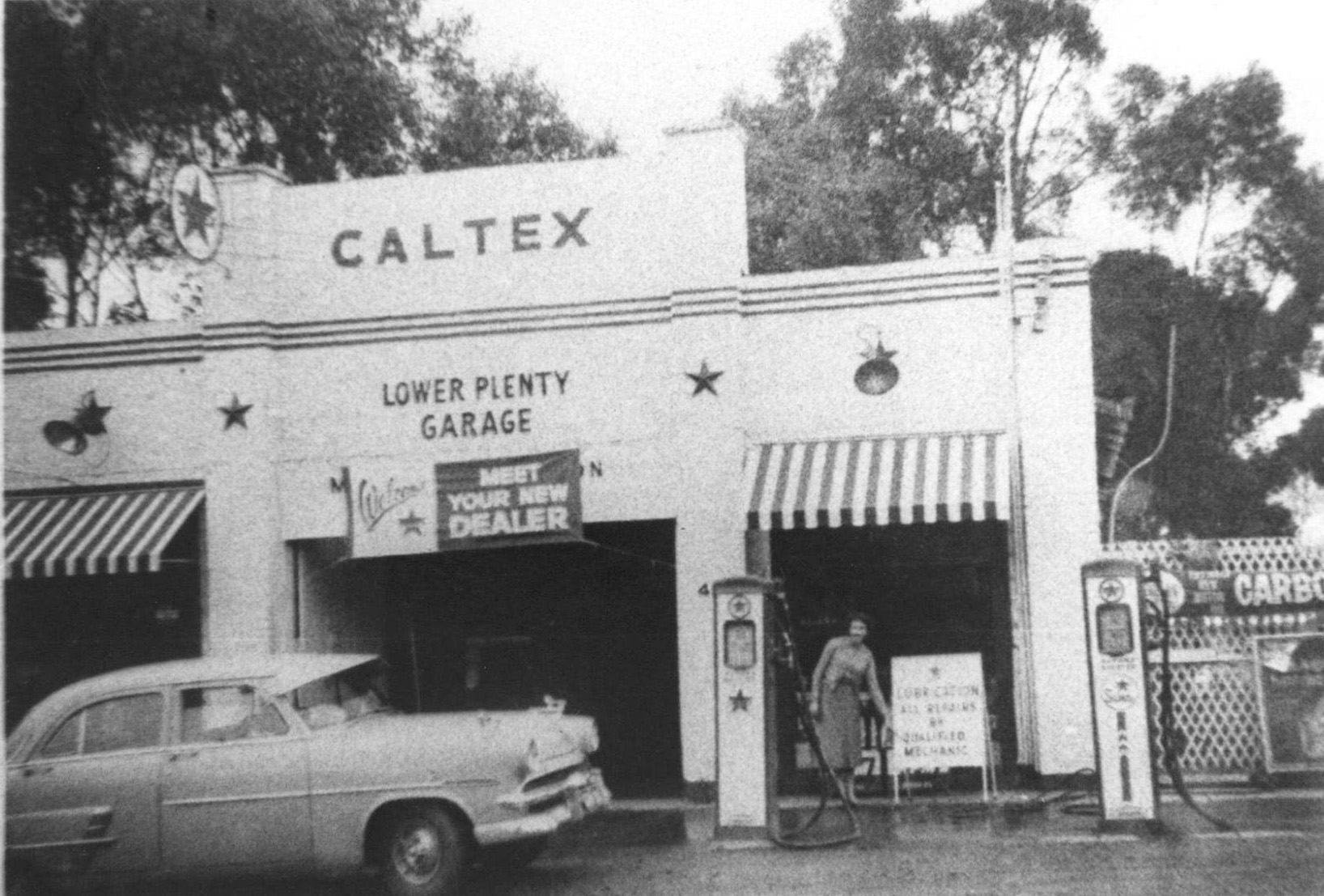
Service station on Main Road in Lower Plenty, c1960.Service station at Watsonia, c1950. (Source: Greensborough Historical Society)
Transportation has changed and roads might be different but disagreements about spending on infrastructure hasn’t changed that much in the one and a half centuries since. The present State government dropped more than a billion dollars to dump the East West Freeway when it came into office, all to prove a point. In the State Budget announced today, the same government released plans to spend another $100 million on a feasibility study of a North East Link, the so called missing link between the Western Ring Road and Melbourne’s south east.
Burgundy Street in Heidelberg, 1950 at the Lower Heidelberg Road intersection. (Source: Picture Victoria, Heidelberg Historical Society image).
The North East Link is an old idea that harks back nearly half a century to the “1969 Melbourne Transportation Plan” which it might be argued was an attempt to turn Melbourne into a Los Angeles of the south. They largely succeeded in that plan for as a contractor once told Arthur Dent shortly before his planet was demolished by the Vogons, “It’s a bypass, you have to build bypasses.” The glaring exception however was the freeway that was to have been built through Heidelberg. Carrying the moniker F-18, the 1969 plan was to drive it through the Heidelberg community like a Thunderbirds’ atomic road maker, road laying machine, cutting a swathe through the landscape. Thankfully the plan was abandoned in the early 1970s and the land in Buckingham Drive and Banyule Road at either end of the freeway reserve was later sold for housing. The Freeway reserve is still there in between in the form of a linear park but the plan is now to either build a tunnel under the City of Banyule or direct the route further out through Nillumbik Shire. Either option fills nearby communities with impending dread.
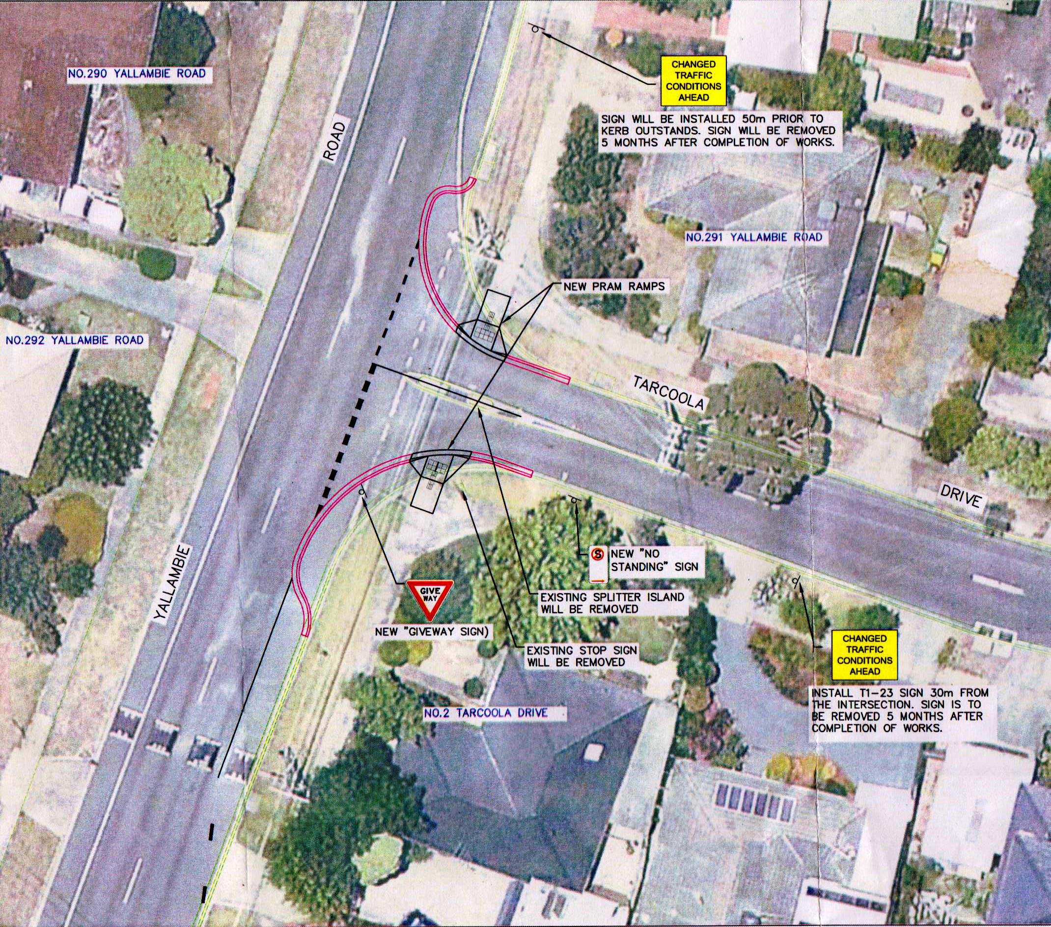
In Banyule, on a local and I might say, somewhat “smaller” scale, the City Council set aside $38,000 in the 2016/17 Budget for the work near us in Tarcoola Drive mentioned at the start of this post. However, they tell me that they are determined to spend only about half of that amount this year, the rest being put aside presumably for when they feel like coming back to do the job properly. Maybe they’ve run out of money already.
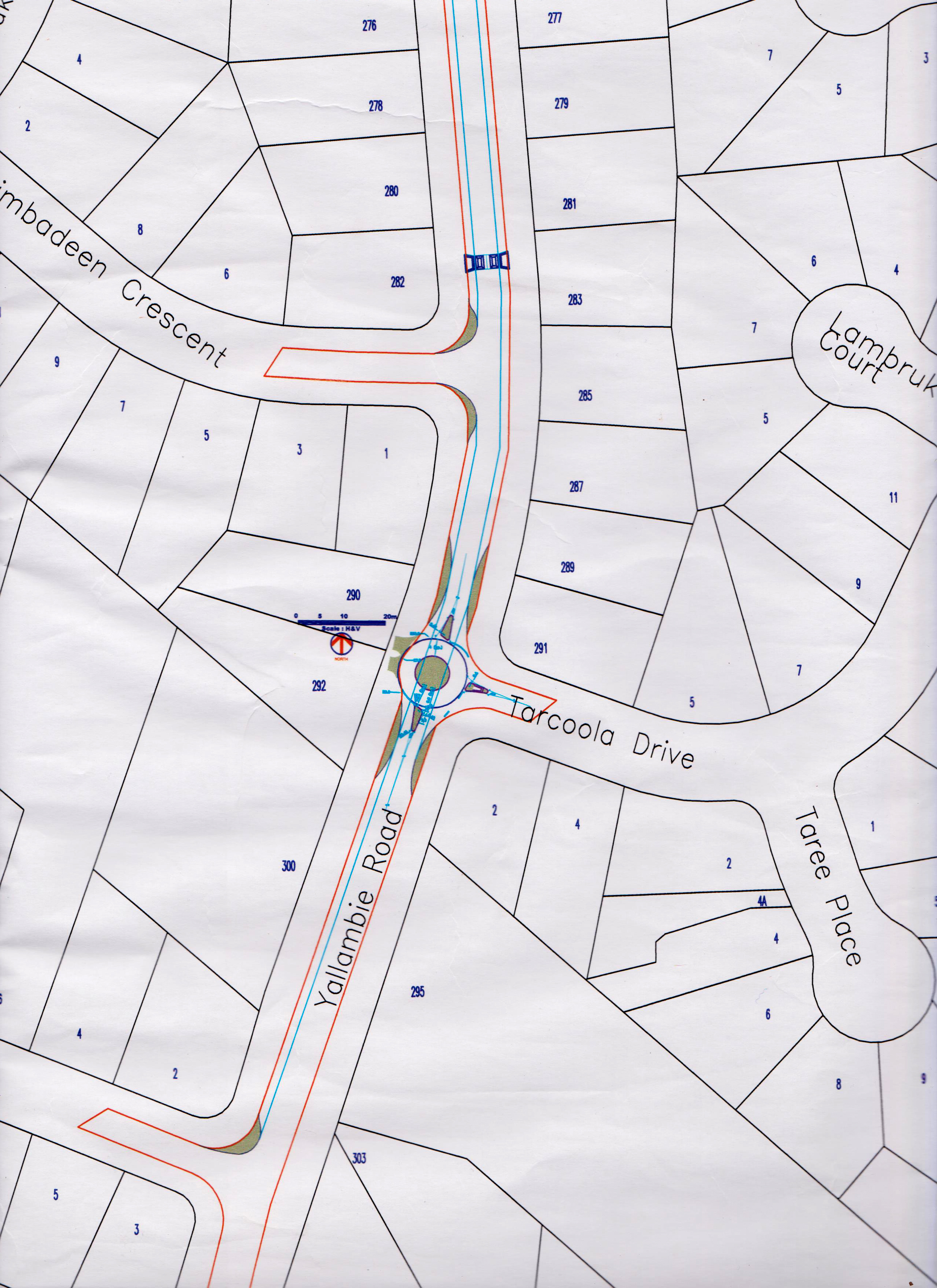
Mid 90’s Council proposal for a retrofitted roundabout at the corner of Tarcoola Drive and Yallambie Road that was never built.Council plan of proposed kerb side alterations to intersection of Tarcoola Drive and Yallambie Road, December, 2016.
Like the F-18 on a larger scale, this is not the first attempt to deal with a perceived traffic problem in Yallambie. In the mid ’90s there was a proposal drawn up to transform the same corner into a retro fitted roundabout, a project aimed at slowing traffic in Yallambie Road, as opposed to the current attempt at slowing traffic in Tarcoola Drive. That roundabout was never built, but was constructed instead onto the corner of Binowee Avenue and Yallambie Road near the shop with speed bumps formed at the approaches.
To add a bit of currency to an old problem, yesterday afternoon our son came in from school and said that as he crossed Lower Plenty Road to Yallambie Road with a green pedestrian light, he had”nearly been run over by a car turning the corner.” In 1993, during the development of Yallambie’s Streeton Views subdivision, the Traffic Engineer for the project Greg Tucker reported that a grade separated pedestrian overpass across Lower Plenty Road to the schools in Viewbank was unwarranted. “The provision of traffic signals at Grantham and Crew Street would incorporate pedestrian crossing facilities in any event…” (City of Heidelberg business paper, 8 Feb, 1993). In subsequent developments, the Martins Lane intersection was substituted for Grantham Street.
The sharp bend at the Old Lower Plenty Road Bridge was a notorious local traffic hazard until the realignment of Lower Plenty Road across the modern bridge. (Source: Greensborough Historical Society, Eltham Historical Society image)
I’ve heard tell that it used to be an unofficial policy at VicRoads to undertake remedial roadwork but to do so only after a road death had occurred. A bit like shutting the barn door after the horse has bolted. The profusion of roundabouts and speed bumps at the northern end of Yallambie Road are something that was added after 1980 and only after the pedestrian death of a child on Yallambie Road near the Primary School. In those days Yallambie Road was a sort of alternative route to Eltham bound traffic on Greensborough Road. The 46 page “Yallambie Road Traffic Study” prepared by Nelson English, Loxton & Andrews for Heidelberg Council in 1982 reported that approximately a third of all traffic on Yallambie Road was through traffic and that up to 78% of traffic exceeded the then maximum 60 km/h speed limit with the highest speed recorded at 100km/h. The report also noted that the impending signalisation at both ends of Yallambie Road was expected to result in even more through traffic.
The decision three years later to extend Elonera Avenue, Yallambie in the City of Heidelberg through to Elder Street, Greensborough in the Shire of Diamond Valley as a part of the Daniel’s sub division opened up another access point into Yallambie, This time from Greensborough in the north. The Yallambie Community Association which was a then very active institution, strongly opposed this connection, but their collective voice remained carefully ignored by those who make the decisions. Once again the ad hoc solution has been to retrofit speed humps, this time along Elonera Avenue.
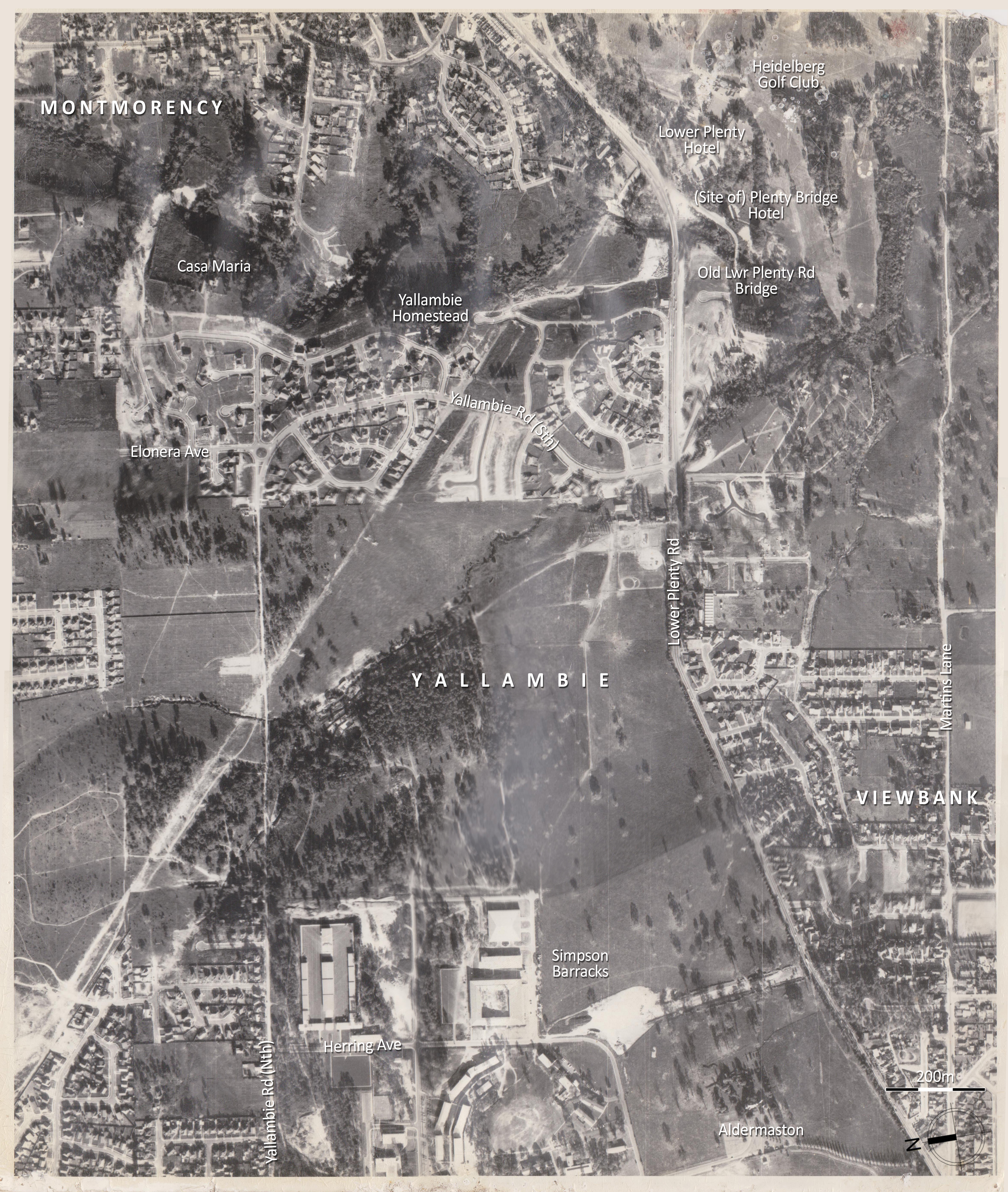
An aerial survey photograph made of the still some what under developed Yallambie area prior to 1971. Note the abrupt end of Elonera Ave to the left of the roundabout, before its extension as a part of the Daniel’s property sub division.
The folly of creating communities without satisfactory infrastructure is nothing new. What happened at Fishermen’s Bend in Port Melbourne is a case in point and is a classic example of what can happen when the profits of a few investors and developers are put ahead of the interests of the wider community. At Fishermen’s Bend, a few property developers, mostly with connections to the then Liberal State Government, became insanely wealthy overnight when the former industrial land they had invested in was rezoned with a stroke of a pen to allow multistorey apartment buildings. Some individuals made profits of over 500% on their investments but planning for residential infrastructure such as schools and roads was almost completely disregarded in the process, leaving taxpayers to pick up the tab at a later date. It has been described as a classic example of how not to develop land ear marked for urban renewal.
Sometimes it’s not about what you know but who you know along this highway of life. The Premier of Victoria at the time of the release of the 1969 Melbourne Transportation Plan freeway blueprint was the legendary, late Sir Henry Bolte. Ol’ Henry reportedly enjoyed a tipple now and then but in March 1984, long after his retirement as Premier, Bolte suffered serious injuries when the car he was driving collided with another vehicle near his home. Surveys here and abroad have consistently reported that the majority of road accidents happen near our homes but in this case it was alleged at the time that Henry had been drink driving. In the end, charges were never laid after the police mysteriously “lost” the blood sample taken from the injured ex-Premier after his crash.
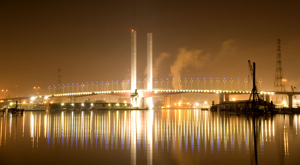
The Bolte Bridge, named after Victoria’s longest serving premier. It spans the Yarra River and Victoria Harbour as a part of the CityLink road system. (Source: Wikipedia)
Bolte recovered but his legacy remains in the testament of the road network that he envisaged and that has been built right across greater Melbourne. Maybe one day we will all be travelling in driverless Tesla cars on this network, but the vote as far as it affects Banyule remains out.
Personally my money’s all on a future involving the Jetsons’ flying car.
Select sources: Heidelberg - The Land and Its People, D S Garden; The Diamond Valley Story, D H Edwards; The History of Our Roads, Maxwell Lay in The Heidelberg Historian, June 2005; Yallambie Road Traffic Study 1982, Nelson English, Loxton & Andrews; Yallambie Community Association papers; City of Heidelberg business paper, Feb 1993
In Douglas Adams “The Hitchhikers Guide to the Galaxy”, the hitch hiking alien names himself after a motor car, believing it to be a safely inconspicuous nom de plume while visiting planet Earth after erroneously misidentifying the dominant life form of our world. Look at any Melbourne road at peak hour these days and you might forgive the alien his misconception. In the words of a recently defunct Federal Treasurer, “poor people don’t drive cars” but if that were true, then judging by the traffic on Greensborough Rd these days, we Melbournians must be an entirely wealthy lot.
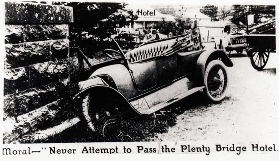
The Lower Plenty Rd Bridge and the Plenty Bridge Hotel, photographed by Mark Daniel, 1900, SLV.
Last November in the process of writing about the one-time site of the Plenty Bridge Hotel, formerly located across the river from Yallambie at Lower Plenty and removed at the end of the 1950s, I made the rather farfetched yet hopeful suggestion that the old hotel might be reconstructed on vacant ground adjacent to a new housing development at Edward Willis Court.
Bicycle riders at the Plenty Bridge Hotel, c1900-1910, SLV.
Ten months on and there is activity all aplenty down on the Plenty, but not the sort I necessarily envisaged when writing that post. You see, what’s being built over at the Lower Plenty site right now is no piece of resurrected local history but a car park. As we all know, the world needs more car parks. We need them like music needs more cow bells.
When I saw the tractors trundle out onto the former location of the Plenty Bridge Hotel at the start of last month, I initially deluded myself that this might be the harbinger of better things to come.
Snakes alive at Lower Plenty, September, 2015.
Across the road, on the corner of Para and Main Roads, a newly installed public sculpture hinted at community pride while a notice in one shop window asked for public help developing a display describing Lower Plenty history.
Poster in shop window at Lower Plenty, September, 2015.
Plans are even afoot to redevelop the former Ampol service station site as a franchise store of a certain large, German supermarket chain. An exercise in urban renewal I guess. So when I need a litre of milk in the future it will be handy to know that I’ll also be able to pick up a pair of snow shoes locally while I’m at it, just perfect for the next time we have a blizzard.
So it came as a bit of a shock to watch the tractors roll right across the site of the Plenty Bridge Hotel, grading its story into the dust once and for all time. The process even involved the destruction of the last Lombardy poplar on the site, a tree that is visible in nearly every old picture of the Plenty Bridge Hotel and the survival of which orienteered the casual passerby with an eye for history to the original location of the building.
Golf Club Hotel, aka, the Plenty Bridge Hotel, looking south west, c1950Site of former Plenty Bridge Hotel, looking south west, November, 2014Site of former Plenty Bridge Hotel, looking south west with stump of Lombardy Poplar visible at center, August, 2015.
Possibly the new car park will be a very nice car park, as car parks go. Adams’ hitchhiker might even feel at home. It appears that the Lower Plenty Hotel applied for planning approval to develop the area as a lower level car park for their hotel patrons as early as October, 2010. This was authorised by Banyule Council in May the following year with amendments in July, 2012. By 2015 work had not commenced on the project and Council refused to allow an extension to the permit. However this was over ruled on appeal at VCAT with work finally commencing about two months ago. Responding to my enquiry, an officer at the Department of Planning at Banyule Council informed me that the status of the Lombardy poplar as an “environmental weed” meant that it would not have been protected by the ”Significant Landscape and Environmental Significance Overlay controls which affect the site”, whatever that statement might mean. The poplar was on the periphery of the development and not intrusive. Its removal was unnecessary and however it’s dressed up, from the perspective of historical significance, it strikes me as misguided.
Car park under construction at Lower Plenty Hotel, September, 2015.
Next month I note that, as a part of the Royal Historical Society History Week, a representative from Banyule Council is booked to lecture at the Watsonia Public Library about the importance of the Significant Trees and Vegetation Register. Yes, there really is a register and a number of the trees at Yallambie within both public space and on private land are on it. What this actually means in practice I would be interested to learn. At Yallambie in the last few years we have seen a century old Hoop Pine and similarly aged Irish Strawberry removed from private gardens. Add these to the disappearance of the Pre-phylloxera grape vine in Yallambie Park and the demise of assorted Italian Cypresses and the old stand of English elms and it is easy to see a pattern developing.
The Yallambie Hoop Pine referred to above was destroyed ostensibly because of the potential damage its root system might do to the drive way of the private home it flanked, although the needs of cars in this city are nothing new. The recent state election was largely fought as a referendum between the freeway and public transport lobbies but it is a debate that has been going on much longer than that. The very first “self-propelled” vehicles of the 19th century were required to be led by a pedestrian waving a red flag or carrying a lantern to warn bystanders of the vehicle’s approach. The F18 Freeway, the so called missing link in Melbourne’s road network and designed to connect traffic on the Western Ring Rd with the Eastern Freeway, is still mentioned every time traffic on Greensborough Rd grinds to a standstill. That battle was fought in the 1970s and won by the anti-freeway lobby. Today it is discussed in the terms of a tunnel under Banyule.
Cars might be a fact of life but what would aliens really think if they happened to drop by and observed the precedence we give to them? In 1960, Lucerne Farm, the former home of Thomas Wills at the confluence of the Darebin Creek and Yarra River, was demolished to make space for a car park for the La Trobe Golf Club. Thomas Wills had been the first owner of the land that became Yallambie. He purchased it in 1836 from the Crown (nobody asked the Wurundjeri what they thought of this) and held onto it for only a few months before selling it to Thomas Walker at a profit. He would have done well in the real estate trade of the 21st century.
Lucerne Farm, the National Trust classified, former Alphington home of Thomas Wills, photographed by Colin Caldwell before demolition c1960, SLV.
More recently, on the corner of Yallambie and Lower Plenty Roads, an assembly hall was built by an evangelical church. Even before the building was finished a car park went in across the site, obliterating in the process the remnant features of a dam which had survived there from the farming era up to that point. An old weeping willow was fortunately retained and it survives on the corner to this day, despite having earlier lost approximately one half of its canopy when Lower Plenty Rd was widened 20 years ago.
Will Wragge pictured alongside one of several tanks (dams) at Yallambie at the start of the 20th century, (Bush collection). In 2013 a dam similar to this on the corner of Lower Plenty and Bannockburn Roads, Viewbank was asphalted as a carpark, an old willow similar to the tree in this picture remaining to this day to mark the spot.
So where do cars fit in with life in a capital city of the 21st century living under the looming threat of Peak Oil? Many people are defined by their cars and cannot envisage a life characterised without them. I’m fast approaching that time in life when a man is supposed to go out and purchase a Harley Davidson in vain glorious pursuit of youth, but when our son recently asked which vehicle would I replace our 16 year old Japanese car with if I had the choice, I replied, “A Morris Minor.” I think he was hoping I would say a Lamborghini.
Not a Lamborghini in the farm yard at Yallambie, c1930.
The Morris or so called “Noddy” car was the first car I ever owned and came with me when I moved to Yallambie. It sat out in the open in front of Thomas Wragge’s old brick garage for years, gradually rusting into venerable retirement. I let it go eventually, fearful that if I left it there much longer it would eventually become a roost for chickens. Observing it leave Yallambie for the last time on the back of a trailer was like watching the days of my youth driving off out of my life. The inclination to one day own such a car again proves I’m really not so different to the next man.
Or visiting alien.
The Noddy car leaving Yallambie for the last time.
An early view of St Johns Church of England, Heidelberg from the north
It was already old when I was young.
From the outset, St John’s Church of England was always there, it’s influence on district life felt or implied in many ways. Later, when I knew the church, the Reverend Simondson had by then become an institution. Perhaps he had been there from the start? The Rev’s piano accordion was like a white toothed chest appendage that squeaked when he moved, his weekly pastoral crusade to the young heathens of Banyule Primary School a regular thing.
Recollections of the church in spring time, Sunday School classes moved outside into the crisp, fresh air of the park to make the most of a beautiful morning. Children singing “Jesus Loves the Little Children”, its lyrics loaded with unintended racism. Book prizes at Christmas and the annual Parish fair. The hard work of the Ladies’ Guild on the white elephant stall like an elephant in the room. A bus, lying mysteriously on its side on the banks of Salt Creek one Sunday morning some time in the 1970s. Its brakes had failed at the top of Burgundy Street and it had careered out of control with a load of schoolgirls before overturning in Heidelberg Park. The driver was killed, the girls shaken. And always the church bell calling the faithful to worship. When I was old enough I had the job sometimes of ringing it. A temperamental thing, it was harder to get it swinging than I had imagined.
It all started readily enough when we were quite small, my parents simply asking, “So where do you kids want to go to Sunday School?”
“What’s that?”
“It’s like school, but on Sunday. Sunday, school, get it. You could go to the church in Arden Crescent where you went to kinder or St John’s in the Park where we were married.”
My sister answered for both of us. She usually did. “I want to go to the place Mummy and Daddy got married.”
‘There’s a school on Sunday?’ I thought with a sinking feeling, maybe. ‘I wonder if there will be finger painting?’
St John’s Church of England, Heidelberg from the south west before addition of side porches below the bell towerSt John’s Church of England, Heidelberg from the north east before addition of side chapel &, vestry
The association of Yallambie with St John’s Church of England, Heidelberg, the third oldest church in Melbourne, goes back a long way. The Bakewell brothers at Yallambie, like their friends and relations in law the Howitts, were Quakers at the time of their arrival in Australia. Quakers or the Religious Society of Friends (or Friends as they call themselves), other than making porridge believed in a doctrine of the priesthood of all Christian believers. They avoided creeds and the hierarchical structure of churches and refused to swear loyalty oaths or participate in wars. The established churches “viewed the Quakers as a blasphemous challenge to social and political order” which in an earlier time, before the Act of Toleration, led to a degree of persecution.
John Bakewell’s name appears alongside that of Dr Godfrey Howitt on a grant of a burial ground in Melbourne to the “Society of Friends” by the Governor of New South Wales in November, 1847. However, by the time of his return to England in 1857, Robert Bakewell’s resignation from the “Society” was accepted by the Nottingham Monthly Meeting (of Quakers) because “he had entirely discontinued his membership during his long residence in Australia.” (Minutes of Nottingham M. M., February, 1857).
Possibly Robert and John had found that during their stay in Australia, their support for an as yet unestablished outpost of Quakerism in Port Phillip gave them little scope to advance their aim of creating a successful farm in the English character on the Plenty River. In an era when the interests of church and state were often intertwined, it was the Church of England that was at the seat of power in Port Phillip. It is believed the Bakewell brothers, like their brother in law, Dr Godfrey Howitt, lost interest in Quaker activities some time after arriving in Port Phillip. In the case of Howitt, his “gradual alienation from ‘Friends’ followed his increasing identification with ‘upper’ classes of Melbourne and with the established church”. (Quakers in Australia in the 19th Century,William Nicolle Oats).
When plans were drawn up by the Church of England diocese to build a church in the Heidelberg parish, on the list of donors alongside the names of church trustees, local gentry Hawdon, Martin and McArthur, the Bakewells’ name appears in the Church accounts book, their initial contribution being £10. (The pre gold rush wage of an agricultural labourer in 1850 was about £26 per annum).
A grant of two acres which had been reserved in the “diamond shaped” village green of the original subdivision of the Warringal village was secured from the government and the foundations of St John’s Church of England were commenced in 1849. The foundation stone “J. W. 1850”, believed to be the oldest surviving engraved stone of this sort in Melbourne, was laid the following year and the building officially opened in October, 1851.
Engraved foundation stone, St John’s Church of England, Heidelberg
The architectural style of St John’s is reminiscent of an English Parish church from the Decorated period of English Gothic Revival. Its idyllic setting near the river curiously drew this comparison with Yallambie in the 1987 Loder & Bayly, Marilyn McBriar Heidelberg Conservation Study:
HEIDELBERG PARK/ST. JOHN’S Existing Landscape character This zone is dramatically different from any area previously described. Its closest affinity is with Yallambie well to the north… The area is characterised by old plantings of mixed conifer species and a minor sub-planting of deciduous trees.
Thomas Wragge, who purchased Yallambie from the Bakewells, was a staunch Anglican and became a regular worshipper at the church. In the words of one of his descendents, “He probably thought he owned that church.” His commitment extended also to the home. In the homestead that Thomas built at Yallambie to replace the earlier Bakewell farm, it is recorded that it was Thomas’ habit to read a service to his family every morning. On one occasion while reading an appropriately filled fire and brimstone sermon through a thunderstorm, Thomas turned to a window and indicated a horse that had been killed by a bolt from above, emphasizing by example the fate to be expected of those who wandered from God’s grace.
“(He) always had a service in the morning and (once) he was just sort of reading — blessing the gathering and there was a frightful crack of lightening and a clap of thunder together. And Olive said she was looking out and then underneath the oak tree in the paddock a horse was struck by lightening so she said she would always remember the prayers at Yallambie.” (Quote from Classing the Wool and Counting the Bales, Winty Calder, Jimaringle Press, 1996).
Horse carriage in the farm yard just north of Yallambie Homestead.
In an age when Sunday was still “church day” and most people attended regularly, the Wragge family were active members at St John’s, Heidelberg travelling there regularly to Sunday services along Lower Plenty and Rosanna Roads by horse and carriage, but never it seems by motor car. At least not initially. In some ways, Thomas Wragge was very conservative and it has been said that he believed that the novel machines that started to appear in the Heidelberg district at the end of the 19th century were wicked instruments. His son Harry had enjoyed the use of a bicycle for some time but Thomas forbade his family to have anything to do with motor cars. However, in the case of at least two of his sons, perhaps his wishes were not always entirely respected.
Young Harry Wragge and his bicycle on the road to Yallambie, c1895
“(Before Thomas died) Syd and Harry were very keen to get a motor car, but their father would have none of the new-fangled idea. He held strong views that horseflesh had served him well all his days, and that motors were an invention of the devil. Harry would not take ‘no’ easily, and kept plaguing away for consent, until Thomas finally told him he would be disinherited if he got one of the hateful things. The family was most concerned about this, because they knew that the old man might well carry out his threat. To their horror, a little later, the whisper flashed through the family that Harry, despite all threats, had got a car (a Hurtu) and was keeping it secretly in town. Harry had, in fact, done just that. Many a quiet run he had round and about after doing all possible to find out where his father might be going, so he could go elsewhere. Cars were not registered and carried no identification numbers.
“During one of these runs, his one-lunger (sic) was snorting south in Nicholson Street a bit north of the Exhibition building where the road is fairly level. A policeman on a push bike decided he was speeding and called on him to stop. Harry began to panic, visualising his name in the newspapers and his inheritance gone, so he decided to make a run for it. The bobby came pedalling after, and Harry gradually drew away on the level road. Reaching the slight rise to the Exhibition building, the car slowed up and soon the bobby was right behind breathing heavily and gasping threats. It seemed that capture was imminent, but with a flash of genius, Harry slapped on whatever brakes he had; the bicycle crashed into the rear and the policeman took a fearful toss with a buckled front wheel. Harry and car escaped unhurt, and Harry had saved himself from the loss of perhaps £50,000.”
(Extract from Classing the Wool and Counting the Bales, Winty Calder, Jimaringle Press, 1996).
It is doubtful that if Harry had been caught that day his father would have taken such drastic steps as to disinherit him. At the end of his life Thomas had put aside his reservations and had entered into arrangements with The Motor House Company for a Brazier priced at £475. This was not delivered until two weeks after his death on 12 May, 1910. All the same, it is nice to imagine his widow Sarah Anne, who took possession of the car, driving it like Granny in Tweety and Sylvester until her death five years later. Picture the sales pitch of that car, which had by then been replaced with another. “Practically new you know. Hardly anything on the clock. Driven by a little old lady who only took it to church on Sunday.”
Thomas and Sarah Ann Wragge in a Brazier outside Yallambie Homestead shortly before the death of Thomas, 1910
The children of Thomas and Sarah Wragge all became regular parishioners at St Johns, in between visits to the family’s sheep station in New South Wales. Tom Wragge (Thomas’ eldest son) was confirmed at St John’s on 20 June, 1878 and Annie (his eldest daughter) on 18 July, 1889. Caroline Victoria Wragge (Thomas’ third daughter) married Francis James Wright at St John’s on 14 October, 1896 and Annie married Wallace Murdoch there on 20 August, 1903. Annie and Wallace’s daughter, Nancy Wragge Murdoch was baptised there in 1905. Nancy would later inherit Yallambie Homestead through her mother and live there until the end of the 1950s.
In 1907, Thomas Wragge gave £500 to the vestry of St John’s Church of England, Heidelberg to help them purchase adjoining pieces of land in Yarra and Hawdon Streets to build a new church. “This land was wanted because the population of Heidelberg was then concentrated near the railway line, and it was thought that the old church was badly placed. The church hall was moved to that land, and a new vicarage was built on it.” (Classing the Wool and Counting the Bales, Winty Calder, Jimaringle Press, 1996) “…the basic wage was 7/- per day, £4.2.0 per week, so approximately £210 per annum. So Mr Wragge’s generous offer is equivalent to about two and a half annual basic wages.” (A Church in the Park, St John’s Anglican Church, 2001).
Membership of the Church of England was a spiritual comfort to Thomas and his family and they are remembered there with at least two memorials. The Holy Table or altar at St John’s was a gift to the church by the wife of Thomas Wragge, Sarah Anne in 1902. Solidly constructed of polished blackwood and with a carved front it stands appropriately before the magnificent Wragge family “Ascension Windows”. The windows were a gift to the church in 1920 and dedicated by three of the children of Thomas and Sarah Ann to the memory of their late parents. It was recorded in the church minutes of 1920 that the Wragge family at that time “desired the best position in the church” for their proposed windows and that the vicar therefore suggested the chancel in the sanctuary, the arrangement replacing an earlier design of geometric stained glass. The Wragge windows show Christ ascending with an aureole of cherub like faces adorning the perimeter. The Holy City is shown below with the apostles bowing in reverence. The left and right panels show Mary and John. The triptych bears the following inscription: “In loving memory of Thomas and Sarah Ann Wragge for many years worshippers in this church. Presented by their daughter Annie and two sons Syd and Harry 1920.” I read that inscription often in bygone times, the man in the front pew perhaps looking at his watch during the Reverend Simondson’s sermon. Who were Thomas and Sarah Ann Wragge in life? I didn’t know.
The Ascension Windows triptych at St John’s Church of England, Heidelberg. Inscription reads,”In loving memory of Thomas and Sarah Ann Wragge for many years worshippers in this church. Presented by their daughter Annie and two sons Syd and Harry 1920.”
St John’s became the mother church of several other churches throughout the district. Upon his death on 12 May, 1910, Thomas Wragge left Yallambie to his wife Sarah Ann, excepting one acre of land on the north west corner of the property. Under his will, Thomas Wragge bequeathed this land to the Church of England with the stipulation that a church should be built on it. The transfer of land was finalised in 1912 and construction of a church began. Conceived possibly on grand lines, the Church of the Holy Spirit, Watsonia on the corner of what is today Yallambie Road and the Greensborough Highway, was never completed. It’s boarded up, unfinished end became the home of roosting pigeons. In the 1950s the congregation of the Church of the Holy Spirit moved to a new location closer to the population centre of Watsonia near the rail station. A petrol, service station would later occupy the Greensborough Road site on the edge of Yallambie. There’s probably a moral somewhere in that story.
In the early 20th century there had been a notion of relocating St John’s, Heidelberg to the land in Hawdon Street that had been given to the church in 1907 by Thomas Wragge. In 1958 however, a decision was made to consolidate Parish operations at the old church in the park. The Hawdon Street site and its hall were disposed of, the sum realized for the Parish being £17,050. The upper and lower church halls at St Johns at the front of the building were built at this time and a side chapel, vestry and porches were added to the church. In 1966, soon after the alterations were reconsecrated, the Ladies Auxiliary of St Johns organized an historical exhibition of local significance to raise funds for the Church Missions. The considerable interest which the exhibition generated directly resulted in the formation of the Heidelberg Historical Society which today bases itself nearby at the Old Court House in Jika Street. For another half century the St John’s Church of England site remained relatively unchanged drawing this praise just a decade ago:
“It must have been good to hear it (the church bell) ring out for the first time from the square tower so cunningly located that it formed the focal point of a vista through an avenue of eucalyptus from the main road. We are grateful today for the foresight that chose a lie of the land that still enables one to see the tower across a modern suburb; and for later municipal planning of parkland which saves the church from being ‘built out’.” (Extract from “A Church in the Park”, St John’s Anglican Church, 2001).
Banyule Council’s report “Heritage Guidelines for Warringal Village, 2006” describes the Warringal Village/St John’s/Heidelberg Park precinct as “historically, aesthetically and socially” significant and states that”St John’s Anglican Church, at the highest point in the township, is the dominant key structure… The church, and more particularly its spire, may be seen from a number of points in the Area. It is a highly picturesque element that underscores the early history of the Village reserve.”
The same report makes these recommendations:
“The size and shape of new buildings should relate sympathetically with those of the adjacent significant buildings. New buildings should not dominate existing significant places… New buildings should respect existing settings and neither dominate nor obscure views or sight lines to existing significant buildings.”
Building work on Burgundy Street, Heidelberg, church & car park on left, November, 2014
So just what is going on at St John’s today? If you stand at the lower end of Burgundy Street and look across Heidelberg Park to the view that was formerly of St John’s Church of England, all you will see now are medium level apartment buildings. The unit developments that have been built on Burgundy and Jika Streets along the south west boundary of the church threaten to overpower the site. But they are nothing when compared to what has most recently gone in behind the church on Vine Street on the south east boundary. “Streeton Park on Yarra” as it is styled is a Freemasons premium retirement living complex conceived on a large scale. A deep excavation has been made up to the fence line of the church and a balcony apartment block built which now completely dominates the location, rising above the dugout and standing above ground level almost as tall as the tower of the church itself.
Streeton Park on Yarra & St John’s Anglican Church, November, 2014
Before this project was commenced, the then mayor of Banyule was quoted as saying in the Heidelberg Leader newspaper that not everyone wanted a garden and that many people wanted affordable living, like that which would be provided by the new project. Trouble is, that’s where the argument falls flat. “Streeton on the Park” was not conceived as affordable housing but is a premium retirement complex providing a wonderful lifestyle opposite the river.
Streeton on Park, Vine Street, Heidelberg, November, 2014
My parents have their own accommodation nearby in the St John’s memorial garden, the site of their ashes now overlooked by the apartment complex next door. They loved St John’s in life and after their marriage they remained active members of the congregation at St John’s for decades. I still have the letter written by the vestry of St John’s formally thanking my father for the voluntary work he put into the garden in the 1980s. The garden at St John’s then was a place of solitude and quiet reflection. Now it is a place from which to wave to the neighbours.
Wedding at St John’s Church of England, Heidelberg
I am told that the church protested about the Streeton Park on Yarra project and that the objections were taken to VCAT. Failing to have the project stopped there was also an attempt to have one storey removed from the high level plans and to have the buildings set back at a distance from the boundary line. VCAT passed the plans. The Church “turned the other cheek” and not only has the ambience of the location been irretrievably destroyed, but the resulting increase in land values that apartment living encourages means that St John’s itself distressingly must be seen to be under potential threat. In an era of dwindling congregations the church by default now finds itself sitting on acres of premium land opposite Heidelberg Gardens and worth potentially millions.
St John’s Church of England, Heidleberg before intrusion of apartment developmentSt John’s bell tower from the car park with Streeton Park on Yarra apartments behind, November, 2014
Streeton Park on Yarra has taken years to take shape beside St Johns. For a long time it stood as a massive hole in the ground the development apparently on hold. It was like that in 2011 when the church hosted a “Back to St John’s” service to mark its 160th anniversary.
Similarly, in the 1970s the F18 freeway project to link Greensborough Road to the Eastern Freeway stalled within the City of Heidelberg when objections were raised to a road that would have bisected the community and potentially destroyed the important landscape around the Warringal Parklands. The freeway reserve is still there in the form of a linear park called Rivergum Walk at the back of Beverley Road but it is unlikely now to ever be used. But is that the end of the matter?
Signs on Rosanna Road have been asking in this pre election week “Who will fix Rosanna Road?” Who indeed? One party has suggested a curfew on heavy transport on Rosanna Road at night. Another party wants to build a freeway elsewhere, in Royal Park. Nobody really wants to say what everyone is thinking. Like another elephant in the room the ghost of the F18 has haunted successive governments the plans “on display in the bottom of a locked filing cabinet stuck in a disused lavatory with a sign on the door saying ‘Beware of the Leopard’.”
Will the eventual solution of the road problem in Banyule see the destruction of parkland in Warringal as first proposed in the 1960 and 70s, or will the destruction move further out into leafy Eltham, the “outer ring” option? As I ponder this question, I picture old Mrs Wragge seated in her Brazier in the early years of the 20th century driving along a much quieter Rosanna Road to church on Sunday. Money is the religion of the modern day, the speed of living and development at any cost the maxim. Too bad we only have the one planet. In the words of someone somewhere, if a tree falls in the forest and no one blogs about it, who gives a damn?
North east exterior of St John’s showing Wragge window in the end of the Sanctuary at right and Streeton Park on Yarra apartments on left, November, 2014


 Luckily for Arthur Dent, he was able to hitchhike a lift from a passing spaceship to escape the destruction of his hometown by the bulldozers. The rest of us are not so lucky. The decisions made on Melbourne’s road network in the near future will effect this city and the people living in it for generations to come. The destruction of communities in order to build these roads will look pretty stupid when Peak Oil has stopped vehicles in their tracks and left nothing behind other than a hole in the ground and an inter-generational debt with a fiscal and social implication of almost unimaginable proportions.