Tag Archives: Heidelberg

Tempered intemperance

“He persuaded a man from Geelong to pose as a buyer, and that man finally made a deal with Mrs Beaton, paid a deposit and obtained a receipt which he handed to Thomas. It has been suggested that Thomas promptly rode over to the pub, ordered everyone out of it and burnt down the building.”(Calder: Classing the Wool – recounting Thomas Wragge’s solution to Beaton’s sly grog trading at Tulla)

There are plenty of pubs in Australia but only so many matches in a box. While burning down the local might be one way of getting your men back to work, in the settled districts there are just too many pubs to make this practical. Along with the previously recounted story of the Plenty Bridge Hotel in Lower Plenty, in Thomas’ day there was no shortage of drinking places in the Yallambie area, with multiple hotels located at Greensborough and Heidelberg and country style public houses located at other places.

Thomas couldn’t burn them all down. Well, could he?

Horses pulled up outside a country style pub.
Monaghans’ Farmers Arms Hotel, Greensborough was replaced by the present day Greensborough Hotel in 1925. (Source: Greensbrough Historical Society)
A horse and cart in front of a weatherboard building.
Another Greensborough Hotel, on the corner of Grimshaw and Church Streets, was destroyed by fire in 1896. It is unclear whether Thomas was seen nearby with his box of matches. (Source: Greensborough Historical Society)
A man walking in front of a hedge with buildings behind.
The Old England Hotel, Heidelberg with the roof of the pre-gold rush era building visible at right. (Source: Peter Blackbourn collection, FB – restored picture)
The Plenty Bridge Hotel, c1928. Panorama made from colourized screen stills of original footage of the opening of the Heidelberg Golf Club.

Wragge wasn’t the first nor was he the last to attempt to impose some sort of limit on the availability of intoxicating liquor in Australian society. The ups and downs of this story date back to the start of white settlement and Governor Phillip’s laudable if futile attempts to put a ban on the hard stuff. It was a ban that was fraught with impossible difficulties for as Robert Hughes explains in his popular history of Australia, “The Fatal Shore”:

“Colonial Sydney was a drunken society, from top to bottom. Men and women drank with a desperate, addicted, quarrelsome single-mindedness.”

An old coin with a hole punched out of the centre.
New South Wales Holey Dollar, (Source: picture by State Library of New South Wales – Wikipedia)

Banished to the other end of the world and torn from everything and everyone that was near and dear to them, rum was their drink of choice, which was handy since it was also the chief form of monetary currency. Coin had developed an annoying habit of leaving the colony with traders just as soon as it could be imported, a problem not rectified until they started punching the middle out of Spanish dollars. A barter system was what was needed and that’s where rum came in. You could drink yourself into the poor house, or an early grave. Quite often both. The First Fleet convict and skilled blacksmith, William Frazer was one who insisted on payments only in rum and not surprisingly it wasn’t long before he was dead after going out on one too many benders. It spoke volumes about colonial society that a man could drink himself to death at the same time so many lived on the very brink of starvation.

The New South Wales Corp, the infamous “Rum Corps” of history, saw an opportunity and in defiance of East India Company trading rights, set about cornering a monopoly in rum, enriching themselves in the process in ways more akin to the later gangsters of Prohibition era America than the officers and enlisted men of a regiment in the British Army. The coup d’état that ousted New South Wales fourth governor, William Bligh in 1808, was sparked initially by the attempted arrest of the former Rum Corps captain, John Macarthur who had attempted to import an illegal still. Successive governors had previously attempted a total ban on the distillation of spirituous liquor in the colony, but the publication under the very nose of authority of a how-to guide for making bootlegged brandy in the fourth issue of the colony’s first newspaper, the 1803 Sydney Gazette is a good indication of just where they were going on this.

An historic watercolour painting of a man in naval uniform being pulled out from under a bed by soldiers.
“Whose shout is it?” The arrest of Governor Bligh, 1808, artist unknown. What some people will do when it comes to paying their round.(Source: Wikipedia, in the Mitchell Library of the State Library of New South Wales)
William Howitt (Source: Wikipedia)

The soldiers involved in removing Bligh and installing his deputy, Major George Johnston would never have owned up that they were engaged in a Rum Rebellion when they allegedly pulled Bligh out from under the bed where he had been hiding. They would have told you they were engaged in a fight for freedom, which was a bit rich given that they were living in a convict colony and that they were the jailers. In essence, the rebellion was an attempt to maintain the soldiers’ happy go lucky trading monopoly and it wasn’t until 50 years later when William Howitt called it a “Rum Rebellion” in “Land Labour and Gold”, a book in which we remember he also described his visit to the Bakewells’ Yallambee Park, that the term really caught on.

This trade in hard liquor may have been seen by the early chroniclers as a sign of a sort of moral failure of the colony, but the on again, off again nature of the business did not preclude a number of legally appointed legitimate attempts to start a home grown wine and ale industry. As early as 1802, Governor King received a letter from the Secretary for the Colonies Lord Hobart, applauding him for his efforts to stamp out the improper importation of spirits into Sydney while suggesting instead that, “The introduction of beer into general use would certainly tend in a great degree to lessen the consumption of spirituous liquors.”

The First Fleet convict, James Squire had begun brewing something which it’s said vaguely resembled beer soon after arriving and continued to do so in the years following, with and without official sanction. It’s alleged that without hops to flavour his first attempts, James resorted to using horehound herb stolen from the First Fleet medical stores as a sort of substitute, getting away with the crime because the court judges liked a drink. Or so it was said. Eventually Squire managed to establish himself as brewer of possibly local distinction and certainly of considerable wealth, although an epitaph of one of the regulars at Squire’s Malting Shovel Tavern recorded in a cemetery at Parramatta in the early days, perhaps suggests something about the quality of the colonial product:

“Ye who wish to lie here, drink Squire’s beer.”

Beer drinkers at the Plenty Bridge Hotel in the late 1940s. (Source: John Irwin Family Collection)
The bar at the Plenty Bridge Hotel. (Source: John Irwin Family Collection)

Beer drinking was actually seen to be a healthy alternative to drinking water at a time when local water was so often contaminated by pollutants and disease, the fermentation process rendering the water safe. By the time of settlement in the Port Phillip District from the mid-1830s, colonial brewing practices had become pretty well established. James Graham, the Bourke Street merchant and second owner of Banyule Homestead in Melbourne, records in his letters instances where local beers were preferred over the imported products, the colonial beer being not only cheaper but more readily accessible.

But it was Howitt who described the goldfields and recorded his observations of the mine workings where the passage of the diggers was recorded not only by the holes made in the landscape but by the piles of empty bottles left behind. Later, in the pastoral era at a place called Innamincka, on Cooper Creek in South Australia, a famous bottle dump grew to be over 200m long and 2m high. The pile of empties was mainly empty rum bottles. To the surprise of no one, there were no Tarax or Fanta bottles. The man-made glass mountain at Innamincka stood for years like a gleaming beacon, long after the place itself had become a virtual ghost town, glistening in the sunlight with a sparkle that could be seen from miles away like a monument to the unquenchable outback thirst.

A pile of old, empty bottles.
The bottle pile behind the old Innamincka Hotel, South Australia,1930. (Source: State Library of South Australia)

The 1830s was the decade that saw the founding of the Temperance Movement in Britain, a movement that advocated a complete abstinence from alcoholic drink. The idea when it arrived in Australia eventually resulted in the creation of coffee palaces which were seen as an alternative to public houses. At 400 rooms, one of the largest of these was the Grand Coffee Palace in Melbourne, (now the Windsor Hotel) which famously and ceremoniously burnt its liquor licence when opened in 1886. It was a show of principle but a show not necessarily rooted in business reality. The liquor licence was returned when it had to be admitted by all concerned that plenty of surreptitious drinking of alcohol was actually taking place at the establishment. The Coffee Palace was fighting a losing battle.

A derelict and windowless building.
The best hotel in Linda, Tasmania, population less than 10. (McLachlan)

Dead blacksmiths and army insurrections aside, it seems that there’s always been a want for this stuff. Show me a one horse town these days where the pub has closed down and I’ll show you a town teetering on the edge of extinction. Even the Yallambie General Store is selling booze now, in its new role as an off licence trader. That store happens to be located opposite our kindergarten, which seems to me to be some sort of a contradiction but then this wouldn’t be the first. Years ago I had a part time job at a licenced grocer in Rosanna from where we would go out in the grocers’ van delivering orders. One regular customer I recall was a trip to the Sisters of Mercy Convent in Rosanna Rd. We left a weekly supply of a dozen bottles of Fosters there, religiously. The nuns used to say that the bottles were for the workman in his garden out back, but I wonder?

A large building and country road photographed from the air.
Sisters of Mercy Convent, Rosanna, c1928, photographed from the air by Charles Daniel Pratt. (Source: State Library of Victoria)

Armed with his box of matches 150 years ago, Thomas Wragge didn’t burn a liquor licence, but a look at a page from a Yallambee day book of the 1860s at a time when Wragge was subleasing the property shows another possibility. In those pages is recorded a surprising detail of a trade in whisky, brandy, ale and aged sherry. Barrels and barrels of the stuff. Maybe Wragge would have told you the sherry was for the cook?

Temperance in its original meaning signifies a moderation of action, thought or feeling and it was only later that it became generally associated with its other meaning, the meaning with the capital T. With a well-stocked cellar and an established tradition of wine making already in place at Yallambie, Thomas Wragge, like many a nun and Colonial Governor before him, and kindergarten teacher after, had arrived at the consensus.

All things in moderation.

Quacked

Since the outbreak of the “mystery virus of unknown origin” in early 2020, there’s been a lot said about the state of our public health system. While roads and tunnels have caught the attention and some might say the imagination of government, it is the chronic underfunding of hospitals that has constantly been exposed in that time. It might seem patently obvious to you for me to say so now, but let’s face it, if you need a hospital these days it’s likely you’ll be taking your life in your hands.

Medical practices and medical practitioners have been around for as long as people have been getting sick and in ancient times there was little to distinguish the rational science of medicine from magic. It’s a long time since the tribal shaman handed out medical advice but after two years of pandemic during which we have heard calls from the now infamous suggestion that people try injecting bleach as a sort of general cure all, to dire predictions from the doctors of WHO forecasting the next global outbreak of pathogen, it’s getting harder all the time to remain objective.

One of the better known Doctors of WHO.

If you look back on the past at the 19th Century to see where we’ve come from, we find that some things that were once standard medical practices are now an anachronism. Bloodletting, which had existed since ancient times, was one thing that persisted well into the Century, the process supposed to rid the patient or should I say victim of impurities in the body. It was performed by a barber-surgeon, as distinct from the physician, and was almost without exception harmful to patients. This barbaric practice might now be a thing of the past but oddly enough it has been commemorated in a curious way by the red and white pole of the barbershop where you get your haircut, the white representative of bandages and the red of blood that once flowed freely under the barber’s ministrations.

Back then the law was far from clear about the credentials required to practice medicine and, bad haircuts aside, claims of extraordinary medical abilities by charlatans proliferated. A “medical degree” could mean just about anything, the only limitations being the owner’s ingenuity and overall resourcefulness. It might be a document picked up second hand in a pawn shop if a legitimate certificate, or forged and worth no more than the paper it was printed on if not. This was the era of the medical quack, the term originating from the middle-Dutch word, “quacksalver”, meaning somebody who boasts or brags about themselves and there were more quacks to be found than ducks on a lake. Quacks like “Professor” Jaeger of Vienna who reportedly made a fortune producing a product he called his “Soul Pills”, having made the discovery he said that the human soul was “not an immaterial spirit, but an odour emanating from the person.”

“This odour the professor has decoyed, bottled, and afterwards infused into “capillary pills”. (Singleton Argus, NSW, Feb, 1886)

Taken internally the pills were supposed to impart the swallower with the best moral and mental qualities, as distilled from others. Oh, if only life was that simple.

A list of potions available to the quack involve some conventional and other not so conventional items including something called “mummy”, supposedly ground up Egyptian mummies taken from their tombs, and “snake oil” made famous in the old West. The notorious snake oil salesman of parody is said to have started in the United States after a man called Clark Stanley sold liniment there which he said contained snake oil, “the cure for everything”. Clark’s oil in fact contained a mixture of beef fat, pepper and turpentine and perhaps unsurprisingly, contained about as much oil distilled from snakes as that other famous yet highly effective analgesic rub, Tiger Balm has ever contained tigers.

Here in Melbourne, from 1860 onwards a certain Dr Hailprim, a self-appointed Jewish Rabbi and occasional fortune teller, offered services to diggers heading to the goldfields that included an alleged ability to auger the location of the next gold strike. When the gold ran out, or very likely some time before, the doctor turned his attention to a chemist shop in Russell Street from where he sold patent medicines. His critics claimed these medicines consisted primarily of “dog fat” and furthermore that the source of the dog fat required a dog to be killed in a particularly strange manner and always at the very stroke of midnight.

Dr Godfrey Howitt, by Samuel Calvert, 1873.

While this was an era famous for its quacks, not all medical men were necessarily cast from this quacking mould. An exceptional exception in Melbourne was the brother in law of Yallambee’s John and Robert Bakewell, Dr Godfrey Howitt. Dr Godfrey had arrived in Port Phillip in 1840 with his family and brothers in law and soon established a very successful medical career at the top end of Collins Street. Howitt was almost single-handedly responsible for the development of medicine as a serious scientific pursuit in Melbourne and was honorary physician of the Melbourne Benevolent Asylum in 1847, a member of the University of Melbourne council from 1853, founder of the University Medical School in 1858 and vice president of the Philosophical Society of Victoria in 1854.

Home of Dr Godfrey and Phoebe (ne Bakewell) Howitt on the corner of Collins Street East and Spring Street, Melbourne, 1868. (Source: State Library Victoria)

Godfrey Howitt died in 1873 by which time it had become illegal to lay claim to spurious medical degrees, although there were always some still willing to try. As detailed in his 1978 book, “Kill or Cure”, Peter Phillips tells of a self-described “specialist physician renowned throughout the Colonies” who was brought before the courts in 1885. When asked if he was entitled to the letters MRCP he used after his name, the physician coolly explained that MRCP did not stand as some might assume for Member of the Royal College of Physicians, but those places he had previously worked – Malvern, Royal Park, Carlton and Preston. The case was dismissed, the judge presumably impressed by the audacity of the “physician” and, according to Phillips, sent out into society to collect as many more letters after his name as there were still places left for him to ply his quackery.

Picture of a hospital facility in the early 20th Century taken from the air.
An aerial photograph of the Austin Hospital, Heidelberg in 1929 with the Warringal village at top right of the picture. (Source: Picture by Charles Pratt, Airspy, State Library Victoria) http://handle.slv.vic.gov.au/10381/20940

Melbourne in the 19th Century was an infinitely developing if infinitely unsewered metropolis. As an urban centre it had sprung into life in response to the gold rushes but beyond the grand public structures, by its unfettered growth it had become a hugely jerry built place which civic authorities struggled to organize and govern. Sickness was endemic in this age before antibiotics and at Heidelberg, Elizabeth Austin was to achieve immortality for her late husband’s name by donating money for a hospital for “incurables”. It’s said she did this after one of her own servants at Barwon Park near Winchelsea contracted tuberculosis and it was found that the only hospital accommodation then available for terminally ill patients from the serving classes was at the badly equipped prison hospital.

large stone house with drive in the country.
Elizabeth Austin’s home, Barwon Park at Winchelsea.

Tuberculosis, or Consumption as it was known, caused widespread public concern throughout the 19th Century and into the 20th but was only determined to be contagious as late as the 1880s. It is spread when a person with an active pulmonary infection coughs onto another. Two of Thomas Wragge’s daughters were to die of the disease, Jessie at Yallambie in 1910 and Caroline (Carrie) two years earlier at “The Trossachs”, in Odenwald Rd, Eaglemont. In Carrie’s case, it is thought the illness developed after she had earlier taken on the care of another consumptive family member, Louisa (Louie) Hearn.

“At that time admission to the Austin Hospital at Heidelberg was avoided as much as possible, because it was regarded as little more than a death house for patients with tuberculosis and cancer. To meet this need, Carrie and Frank took Louie into their home so Carrie could help her, even though she had two small children of her own to care for.” (Calder, Classing the Wool, p140)

The sight of face masks on our streets today might lead you to think that in some respects we haven’t gone that far and indeed have come full circle. Once again prevention has become the simplest form of cure and a bar of soap is the number one item you can put in any medical kit. In spite of this or maybe because of it, the subject still seems somehow to be open for debate.

Hand painted tiles displaying words "do not spit".
An old tiled sign on the walls of the underpass at Flinders St Station, Melbourne. A relic from a century old, public health campaign, the sign survived a recent refurbishment during another health scare.

The year before his 1996 death, Carl Sagan wrote of a foreboding he had of what he saw as a looming time, a time “when awesome technological powers are in the hands of a very few, and no one representing the public interest can even grasp the issues; when the people have lost the ability to set their own agendas or knowledgeably question those in authority; when clutching our crystals and nervously consulting our horoscopes, our critical faculties in decline, unable to distinguish between what feels good and what’s true, we slide back into superstition and darkness.” (Sagan: The Demon-Haunted World, 1995)

I don’t know about you, but I’m off to the barbers. I want to get a haircut, pick up some medical advice and to see a man about a duck.

A duck perched on top of a chimney.

Terra incognita

When it came to naming places in a land they confidently thought of as Terra Nullius, those Brits were a pretty prosaic lot. In 1770 Captain James Cook marked the eastern coast of Australia on his map as “New South Wales”, writing in his journal as he did so that the land he could see from HM Bark Endeavour looked for all the world to him like the Welsh hills. I guess the horizon can look like anything from a rolling deck when you’ve been chewing on sauerkraut for months.

With the arrival of a colonising fleet of convicts 18 years later, a new settlement was established and named after the British Home Secretary at that time, Lord Sydney Thomas Townshend, which is about the only thing we remember Townshend for these days. With the style set it is perhaps not surprising that about 50 years later, when it came to naming the town that was to become Victoria’s capital city, Melbourne was named after a now long forgotten British PM. If the people who actually lived there had had their way though, it might have been different. They initially wanted to call the ragged collection of tents and mud and wattle huts “Bearbrass”, the origins of which name have been debated closely by those in the know but which I have my suspicions may have been simple rhyming slang for something nearer the mark.

Locally, the name of Heidelberg expanded on this emerging pattern. It was named by canny land speculators during Melbourne’s first land boom under the impression there was a quid to be made by comparing the antipodean landscape to a town in Europe no one had ever heard of and which was not yet part of a Federated Germany. When it came to separating from New South Wales though, its little surprise that the names of the new colonies were hardly overflowing with inspiration. Victoria was named after a Queen in a faraway land while the land to the north was named – you guessed it, Queensland. Sheeesh.

All of which rather flies in the face of another sometimes overlooked truth. These places already had names and had done so for tens of thousands of years. The land on which Melbourne was situated was known as Naarm by the first nations, its river was Birrarung and the people were the Wurundjeri. The fact that the settlers called the river the Yarra instead of Birrarung stemmed from a little cross language misunderstanding since the term, yarra was a pronunciation of the shape the current made on the water, and not the name for the river itself. Even when they wanted to give the local names a try, there remained plenty of room for error.

Bakewell era survey map of “Yallambee”. (Source: Bill Bush Collection)

The Bakewells appear to have been one instance of Port Phillip settlers willing to give local names a try. When they were casting around for a name for their farm to the north east of Naarm, a property that had been called from the first days of settlement “The Station Plenty”, “Yallambee” was the Bakewells’ choice. It was an Indigenous word the meaning of which has been given as, “to dwell at ease” although its exact tribal origins remain unclear. It was a popular Indigenous word in the settler community and was used as a place or property name several times under various spellings in Victoria and in the other colonies. Thomas Wragge would later change the spelling of “Yallambee” to “Yallambie”, it is said to avoid confusion with some one or all of these other “Yallambees”.

Lead light sign
“,,,used as a place or property name several times under various spellings”

Indigenous words have found their way into use as European place names regularly across Australia, appearing to be exotic on the one hand while giving just a parting nod to the displaced tribes on the other. When Australia achieved its Federation in 1901, these First Australians were not recognized under the newly adopted constitution, a fact undoubtedly rooted in the racism present in that era but also for reasons that were cynically political. At the constitutional conventions that preceded Federation, it was argued that giving Indigenous Australians a vote would unfairly wait the power of the landed class of rural Australia as it was feared farmers would instruct easily manipulated Indigenous farm hands on the subject of who they should vote for at any election, making a mockery of the whole democratic process.

The lack of citizenship of Australia’s first citizens was to remain an embarrassing oversight and one that was not rectified until a 1967 national referendum allowed a change to the constitution, admitting First Nations people to full citizenship for the first time. The result of that belated referendum at 91% was the highest Yes vote ever recorded in Australia, but it does leave me to wonder, what were those other 9% thinking?

Folding brochure from land auction during subdivision of the Yallambie estate
Folding brochure reversed

This was the era when A V Jennings were busy carving up the old Yallambie estate for subdivision and the time must have seemed right therefore to choose from a plethora of Indigenous words for use as street names. Most Yallambie streets from the Jennings era record some sort of Indigenous word. Tarcoola meaning river bend, Aminya meaning quiet and Kardinia meaning sunrise to name but a few.

A list of Indigenous words used as suburban street names.
A list of street names used on the original A V Jennings estate, from “Yallambie, a history. (Yallambie Primary School, 1971-1991)

In addition to his Yallambee property, John Bakewell maintained interests in several other pastoral properties including a vast run at Western Port, his so called “Tooradin Empire”. The name Tooradin is another Indigenous word and means “river monster”. The first attempt at European settlement of this area had taken place in 1826, partly in response to Hume and Hovell’s glowing report of land they had explored three years earlier having arrived at Port Phillip Bay while believing, due to an error of navigation, that they were at Western Port. Located east of Melbourne, Western Port creates confusion to this day in those unfamiliar with the Victorian coast. Named by George Bass in 1798 while exploring the entrance to the Strait that would later bear his name, the port was at that time the furthest point charted west of the existing settlements.

Map of the Western Port squatting runs, sourced from “The Good Country”, by Neil Gunson, 1968, and marking several but not all of Mickle, Bakewell and Lyall’s properties. These included Tooradin or “Old Manton’s”, Tobin Yallock or “Torbinurruck”, Red Bluff and the Great Swamp.
A brass commemorative plaque
Plaque in Jamieson Street, Corinella commemorating the attempted settlement at Western Port in 1826.

The short lived Western Port settlement of 1826 was not a success but then the whole point of the exercise in the first place had been to obstruct a possible attempt at settlement by the French. The site chosen on a peninsula at what is now the sleepy, holiday hamlet of Corinella was all about British occupation of a strategic and easily defensible location. Soil fertility and availability of fresh water was not considered.

An ongoing French interest in Australia had been demonstrated across a long period by successive expeditions of exploration and another, led by Nicolas Baudin in 1803 managed to chart most of the southern coast line of Australia. Baudin called the coast he explored “La Terre Napoleon”, naming coastal features in French and, like the British, not stopping to make enquiry of the traditional owners. In a letter to the English King’s representative in Sydney, the aptly named Governor King, Baudin wrote however that:

“To my way of thinking, I have never been able to conceive that there was justice or even fairness on the part of Europeans in seizing, in the name of their governments, a land seen for the first time, when it is inhabited by men who have not always deserved the title of savages or cannibals.”

Baudin’s words reflect the Enlightenment principles which, in the early years at least, drove the French approach to Pacific exploration. Nicolas Baudin died on Mauritius on his return voyage to Europe but already a more pragmatic attitude was developing in France. Although the words are possibly apocryphal, Napoleon is supposed to have said of the explorer, “Baudin did well to die. On his return I would have hanged him”, apparently for failing to contest Britain’s territorial claims.

Today, place names like La Perouse in Sydney, the Fleurieu Peninsula in South Australia and French Island in Western Port itself all offer a glimpse of what might have been if Britannica had for one moment ceased to rule the waves during the Napoleonic era but it would be the British names that eventually stuck on the map. It might seem now like these explorers were playing some sort of pin the tail on the donkey, but the process of naming implied ownership. La Trobe University’s Lucy Ellem, writing about the Bakewells’ Plenty River farm in a 2016 unpublished paper, “Plenty Botanical”, states that,The right to name is the right to own. In naming lies possession… The process of naming, which Adam began, guided the Bakewells’ creation of a new Eden, an artificial paradise, in a land of plenty.”

And at Yallambie, a word with a pleasing Indigenous feel, that means to dwell at ease.

Carpe diem

While Yallambie can be rightly regarded as the geographic heart of the City of Banyule, it is the Warringal Cemetery at Heidelberg that is its absolute dead centre. People have been dying to get in there for years, but it seems to me that when they do, they usually don’t have that much to say about it. “Carpe diem,” said Mr Keating, Oh Captain My Captain, but when all’s done and dusted, all that’s left is the dust. The unspoken whispers and forgotten memories of lives once lived. 

The grave of Thomas Wentworth Wills at Warringal Cemetery, Heidelberg.

If you’re lucky, sometimes the epitaphs in a cemetery will offer up an indication of what lies beneath your feet – from Martin Luther King’s “Free at Last” to Spike Milligan’s famous, “I told you I was ill,” but likely as not the stories must remain forever anonymous. At the Warringal Cemetery, the inscription to Thomas Wragge on the Wragge family monument states rather matter-of-factly, “Died at Yallambie, Heidelberg” but nearby is another, rather more intriguing stone with an altogether different inscription. 

“Thomas Wentworth Wills, Founder of Australian Football”. 

So who was Tom Wentworth Wills, “founder of football”, and what’s he doing at Heidelberg? Not much now I hear you say, but in the middle years of the 19th Century on sporting fields across the Colonies, it was an altogether different story. 

Tom Wills’ epitaph at Warringal.

Tom Wentworth Wills was the son of Horatio Wills and nephew and namesake of Thomas, the brother of Horatio. Uncle Thomas Wills has been mentioned before in these pages. He was a prominent early owner of land in Port Phillip, first owner of the Crown land that now forms the Yallambie estate and the owner of Lucerne, one of the finest homes of the early Heidelberg district.  

Uncle Thomas Wills’ Lucerne, c1960. (Source: picture by Colin Caldwell, State Library Victoria)

Brothers Thomas and Horatio were the sons of a former Sydney convict, transported to Sydney for highway robbery in 1799. Relocating to Melbourne in the late 1830s the two men were soon involved in a range of commercial and pastoral activities, owning property in and around Melbourne, left right and centre. 

Molonglo River, photographed by William James Mildenhall, c1920s. (Source: Wikipedia, National Library of Australia)

In April, 1840 Horatio took his wife and their four year old son, Tom up country to a large pastoral run he had acquired at Mount William on the edge of the Grampians (Gariwerd) in the western part of the Port Phillip District. Horatio’s son, Tom Wentworth had been born in 1835 on the Molonglo Plains near present day Canberra and at Mount William it’s said the boy was soon mixing freely with the Indigenous tribes who were still numerous in the area, playing their games and learning their languages. Interestingly, considering what came later, it’s said Tom was introduced at this stage to an Indigenous ball game known as Marngrook. 

After a rudimentary education in Melbourne, young Tom Wills was sent to school at Rugby in Old Blighty where from age 15 he displayed a spectacular disinterest in his studies while excelling at school sports. Tom was soon captaining the School and playing First Class cricket up and down the length and breadth of the land and, in the winter months, the school ball game of Rugby.  

Tom Wills photographed in a studio in Geelong in 1859. (Source: National Portrait Gallery, Canberra) https://www.portrait.gov.au/portraits/2014.57/thomas-wentworth-wills

On his return to Australia in 1856, Tom Wills continued to display a disproportionate interest in sports. He achieved fame playing cricket for Victoria against New South Wales but it was the letter he wrote to a newspaper in July, 1858, calling for cricketers to take up winter sport for which he is now best remembered. The letter resulted in the first ever scratch match of Australian football, played on Saturday, 7 August 1858 between 40 Scotch College boys and a similar number from the Melbourne Church of England Grammar School. One team wore pink, the other blue. The ball was a “huge sewn many seamed round ball” provided by Tom for the occasion and played across a roughly surfaced, half mile pitch. After a fierce contest lasting three hours and without recourse to anything sounding like a set of rules, both teams had scored a single goal.  

“Our football-game had no rules at all. Tripping, elbowing, tackling, or anything else, was practiced with impunity.” 

The game continued the following week, and the week after that but without further addition to the score and the match was ultimately declared a draw. Possibly by that time there were not enough uninjured players left to continue risking life and limb. Looking at all the black eyes and crocked shins, Tom Wills must have thought on reflection it would be better to have something that at least sounded like some rules, so he retired with three others to the local pub to jot something down on a table napkin. It’s unclear now how many drinks the sportsmen had sunk by the time they began writing, but it’s said the rules when decided were based on Wills’ own memories of his Rugby playing days and that “nobody understood them except himself…” 

From such beginnings was a game created. 

Known simply in this country ever since as, “The Footy”, it is a game that even the best informed spectators sometimes have trouble understanding. It requires the endurance of the half marathon runner, the athleticism of the basketball court and at least, in its historic form, the sheer physicality of a combat arena. “Quidditch,” without pads and brooms is how one wag recently put it, but it goes without saying that the early game played by Wills and his contemporaries would hardly be recognisable from what is played across Australia now.

As conceived in that pub, the game initially had recourse to a mere ten rules, with rules soon being added and others altered as time went by. In the words of Geoffrey Blainey, the game was not born ready-made, “The rules just grew, spreading more like a climbing vine than a tree.” 

Two teams playing on a country style ground, (possibly Corio?) in what look like Melbourne and Geelong colours, pre-1900. (Source: Harrington Collection, State Library Victoria) http://handle.slv.vic.gov.au/10381/11535

Tom Wills’ early notion of putting a Rugby style cross bar between the goal posts was never adopted but initially goals could be either rushed across the line or kicked through. Minor scores when the ball went either side of the posts were not counted. Play began not with a bounce or basketball style throw of the ball into the air, but with a rugby style kick off, the players lining up on opposite sides of the field and attacking the ball in a phalanx. The high mark or overhead catch of the ball was a spectacular feature of the sport right from the start, but when it was caught the catcher was required to call out, “Mark” and the game would stop for the player to take the resulting place kick. For decades a mark could also be claimed even if the ball had travelled only the length of a player’s foot, the so called “little mark”, and while throwing the ball has never been allowed, palming the ball with an open hand as a variation on handball, the flick pass, was used almost into the modern era.  

…and the big men fly. Geelong v St Kilda at the Corio Oval in 1914. (Source: Geelong Historical Society, published in The Road to Kardinia, 1996)

From the start, football became a hugely popular spectator sport in Victoria. Long before soccer and rugby became popularly established in the big English cities, The Footy gripped the imagination of Melbourne from where it was exported to practically every Victorian country town and across the land into the other Colonies. The big Australian sporting grounds used for cricket were in plentiful supply and found to be ideally suited to the long kicking which was a feature of the game.  

Arthur Streeton’s “The National Game”, 1889, from the 9 X 5 exhibition of Heidelberg School Artists. (Source: Wikipedia, the Art Gallery of NSW) https://www.artgallery.nsw.gov.au/collection/works/OA11.1963/#about

Australian Footy developed into a sport able to cross social barriers and unlike cricket, it wasn’t a game with a distinction between gentlemen and players. In Melbourne the home grounds of the most important teams were all located near to each other across the inner suburbs with the ground at Geelong accessible by paddle steamer across the Bay. The spectators, the so called barrackers – a word that originated in Melbourne around 1880 – came from every walk of life, an appeal that has continued into the modern era. It wasn’t so long ago when it seems to me a football crowd was dominated by the mums and dads with their Thermos flasks, grandmothers with their knitting and kids with footballs under arm, waiting for a chance to get onto the ground for a kick after the siren.  

What Tom Wills would have thought of sport in the modern era we will never know, but in his day Wills stood alone as the pre-eminent athlete of the Australian colonies. In addition to his endeavours in colonial cricket, which including helping to form a team of Indigenous cricketers that later toured England, Tom Wills went on to play over 200 games of Australian football. He captained both the Melbourne and Geelong Football Clubs which were formed in Victoria in 1858 and 1859 respectively and which are today considered the oldest, continuously existing clubs at an elite sporting level of any code in the world.  

Neil “Nipper” Trezise, (right) a cousin of this writer, chasing after the ball in a Geelong, Collingwood game of the 1950s. The last time Geelong and Melbourne met in a Preliminary Final, the players included, names like Trezise, Bob Davis, Ron Hovey and Ronald Dale Barassi. (Private Collection)
Gary Ablett Snr shows the Hawks a clean pair of heels in ’92. (Private collection)

To follow any football team through thick and thin isn’t easy, especially when the thin seems to be lying so thickly across the playing field. I’ve been a tragic Geelong Cats supporter all my life but those who look at the later day successes of the Geelong Football Club forget now how long that success was in coming. Those who remember Gary Sidebottom left standing on the side of the Geelong road with his kit bag under arm before a Preliminary Final or were with me in the outer at the ’G in ’89 and saw Ablett Snr kick 9 goals in a losing Grand Final side will know what I mean. I don’t believe that ‘Digger’ has really “been following Collingwood for 137 years,” but sometimes when you have a favourite team and follow their travails for long enough, it can feel like that. Perhaps only present day supporters of the Melbourne FC, a team without success within the living memory of most people, can relate.

Neil Trezise punches the ball clear of Dick Reynolds in the last quarter of the ’51 Grand Final. Reynolds, the non playing coach at Essendon, brought himself on at the end in an attempt to lift his side. Geelong went on to win the game in a tense finish by 11 points. Note the huge spectator crowd that has spilled dangerously beyond the fence, completely covering the boundary line. (Source: the Geelong Football Club, published in The Road to Kardinia, 1996)

With a Preliminary Final about to be staged next week between these two famous old clubs, Melbourne and Geelong, the first since 1954, the Cats to start as underdogs, I come back in a roundabout sort of way to my story and what it means to me to find Tom Wills mouldering away in the dust at Warringal.

The match day ball from the 1952 Grand Final. Neil Trezise kicked four goals with this ball that day. (Source: Victorian Collections, from the Geelong Football Club) https://victoriancollections.net.au/items/5a08191a21ea671aa81c88e9
St John’s Church of England, Heidelberg from the south west. (Picture: Cliff Bottomley, 1956)

After retiring from football in 1874 and inter-colonial cricket in 1876, Tom came to live at Heidelberg where the Wills name had once been so widely recognized. From early 1879, Tom lived in a rented house in Jika Street opposite the police station, near the Presbyterian chapel with a cheese factory at the end of the street.  In the trees behind the house stood the tower of Wragge’s favourite church, the St John’s Church of England, and beyond that the Heidelberg Cricket Ground and racecourse. 

Heidelberg Football Club, c1897. The club was founded in 1876. (Source: Wikipedia, http://www.heidelbergfc.com.au)
Heidelberg Oval, 1908. (Source: Wikipedia, State Library Victoria)

Tom is known to have played with and coached the local cricket club at Heidelberg but by then his stature as a sportsman was largely diminished. Tom Will’s bowling action had become suspect but on the rough, unflattened country wicket at Heidelberg in a team made up of yokel farmers, local gentry, and occasional cow herders, no one seems to have noticed. Probably the last recorded outing of Wills on a sporting field was at Heidelberg in March, 1880 when playing cricket for Heidelberg against the “Bohemians” aged 45, he took five wickets, sharing the bowling honours that day with Charles Nuttall, a farmer from Banyule. 

Wills was ostensibly a rather complicated character, to put it mildly. At one moment charming and at another offensive, he had been a drinker since his Rugby days, but by 1880 the truth was he had become an inveterate alcoholic. On 2 May that year, less than two months after the Bohemians game, in a fit of depression he took a pair of scissors and stabbed himself through the heart. 

The jurors at the inquest that followed included such Heidelberg luminaries as Thomas Davey the butcher, Edward Studley the baker and I’m guessing the candlestick maker but the burial of Wills at the Warringal Cemetery after an Anglican service went largely unnoticed, attended by only a half dozen members of his immediate family. 

It was an inglorious end for someone who had been a sporting legend in his own life time. Greg de Moore in his invaluable biography of Wills said he “stands alone in all his absurdity, his cracked egalitarian heroism and his fatal self-destructiveness – the finest cricketer and footballer of the age.”  

So there it is. What happens on the sporting field might seem like life and death, but if you want to get some perspective, look around the graveyard and tell me what you see. “All the world’s a stage, and all the men and women merely players.” If you had looked in at the gates here at Yallambie on three occasions in the early Noughties, you might have seen some lunatics waving blue and white scarves and charging madly around the garden in celebration of victory. That’s what The Footy can do to otherwise sane people.

Carpe diem, Cats, but come what may next week, this is one for the history books.

They call it Shank’s Pony

It’s said that if you’re not careful, waving a red flag could get you a visit from the pointy end of a very angry bull. That’s if you’re unlucky enough to find a member of that bovine species with its horns down and tail up, charging past when you happen to be holding one. Yet in the 19th century a red flag could be the herald of something quite different and in practice, rather more sedate.

The extraordinary 1865 Locomotive Act of Great Britain, sometimes known as the “Red Flag Act”, was an old law that required a man to precede at walking pace all steam powered vehicles on the open road and to carry a red flag or lantern as a warning while doing so. It developed in the middle years of the 19th century after intense lobbying from horse-drawn carriage operators and the railway industry in what was seen even then as a cynical attempt to stifle legitimate competition to their services. The Act gave local authorities unprecedented powers over speed limits which were set between 4 and 2 mph and the authority to specify the hours during which steam vehicles might use the roads, the combined effect of which was to limit the rise of steam powered road transport throughout Britain and her Empire for decades. It was enough to take the puff out of what has otherwise been called, “The Steam Age”.

Towards the end of the century, with motoring innovation and the use of the new-fangled internal combustion engine gathering pace, the Red Flag Act was seen for what it was. A patently absurd anachronism. The Act was amended and in 1896 finally repealed, after which time experimental steam transport was finally free to develop and operate unhindered.

By then it was nearly too late for road steam but all the same there were still some who were willing to try. Thomas Clarkson began producing steam buses at his Moulsham Works in Chelmsford, England at about this time with the company’s prospectus declaring that, “The Chelmsford motor omnibuses are steam propelled, and… are entirely free from smell, noise, and vibration.” The Clarkson vehicles had a two-cylinder horizontal engine with a tubular boiler and a working pressure of between 150 and 250psi and averaged almost 4 miles to a gallon of paraffin fuel.

Victorian Railways No.1 steam charabanc at the Plenty Bridge Hotel, c1905, (Laurie Daniel Collection, Museums Victoria).

At the dawn of the new century A G Webster & Son of Hobart imported a number of these Clarkson omnibuses to Australia and several were adopted by the state railways for use in passenger services on the roads. This photograph of a Clarkson vehicle parked outside the Plenty Bridge Hotel in Lower Plenty opposite Yallambie was taken in 1905, possibly during a proving exercise in that year. Another photograph apparently from the same series shows the same vehicle on a timber covered road, perhaps somewhere in the Upper Yarra or Upper Plenty area, localities the vehicle presumably might have travelled through after leaving the Plenty Bridge. A closer inspection of this photograph appears to show an indigenous member of the party in the middle of the group, looking away from the camera, fourth from the right. Could this photograph have been taken during a visit to the Coranderrk Aboriginal Enterprise near Healesville?

Victorian Railways No.1 steam charabanc stopped beside an up country road, c1905, (Laurie Daniel Collection, Museums Victoria).

In the other picture, the Plenty Bridge picture, Edward Joseph Rigby has been identified seated in the driver’s seat. His son, Edward Jr is standing at the rear of the vehicle along from his mother. Rigby Sr was an engineer and early motoring enthusiast, being a foundation member of the Royal Automobile Club of Victoria. It is believed that he was responsible for the elegant chassis construction of the Clarkson vehicles used in Melbourne.

Six Clarkson vehicles were ordered by the Victorian Railways but they were used for only a short period after proving unreliable in service. Steam transport in Victoria at this time was largely limited to the tried and true uses employed to such good effect by the railways, to which industry it was ideally suited and well established throughout the world.

The story of the early railways in the Heidelberg district reads as a chequered tale. The lack of regional progress throughout the latter part of the 19th century has been blamed mainly on the lack of an efficient, direct route into the north east, the result of protracted councils’ infighting and disagreement over the form such a railway should take and the route it should follow. Getting a train to Heidelberg in the early days involved a juggling act with timetables and a backwards and forwards movement along spur lines before there was even a chance of getting anywhere. As one wag put it at the time:

“In the old days of buses and coaches, travellers could hope, on starting from Melbourne, to reach the place in about an hour, but with the advancing times and the railway communication they could now do the journey in one hour and a half.”
(The Mercury, May 1888, quoted in Garden)

It seems the visit of a Railways steam omnibus to Lower Plenty might have had its merits.

Detail from early rail map of the north east showing the meandering route the Hurstbridge line takes through the Plenty and Diamond Valleys. Yallambie is roughly about where the “d” is on the name of Macleod Station on this map.

Train at Montmorency Station in the early years of the 20th century. (Source: Madden albums of Australian railways photographs, State Library of Victoria picture).

Greensborough Station, c1910. (Source: Greensborough Historical Society)

Steam engine and train at Eltham Station in the early years of the 20th Century. (Source: Eltham Historical Society picture).

A direct steam engine rail route to Heidelberg was finally established in 1901, extended to Eltham in June, 1902 and reached the end of the line at Hurstbridge in 1926. The route as built performs a vast arc around the Yallambie area with the stations at Rosanna, Watsonia and Montmorency all about an equidistance from the main body of the Yallambie housing estate which is centred on the western banks of the Plenty River. A modern regular bus service from St Helena, the 517, connects Yallambie today to train services at Rosanna and Greensborough Stations, although the route it takes through the back streets can add up to half an hour to a trip. This however is about the same time that it takes to walk to Montmorency Station along the Plenty River Shared Trail from Yallambie, so it’s really a case of whether or not you fancy the exercise when you’re commuting. Other bus routes connect Yallambie to all points of the compass with the 513 along Lower Plenty Rd to Eltham and the 293 from Para Rd in Montmorency to Doncaster and Box Hill being particularly useful.

The State Government’s commitment to public transport is clear with the recent removal of the Lower Plenty Rd level crossing and redevelopment of the Rosanna Station being just one local example of this policy. At the same time though, the Government’s decision to build a North East Link freeway down the western boundary of Yallambie and underground through Heidelberg is evidence of another commitment entirely.

“Sleepy Hollow”, Heidelberg, c1890 as Thomas Wragge would have known it before the building of the rail bridge across Burgundy Street. Village development at this stage was concentrated further down the hill in front of the spire of St John’s Church in the park. (Source: photograph by W H Ferguson, State Library of Victoria picture).

With the use of hybrid cars and Peak Oil giving the roads of the future an unknown prospect, it remains to be seen what shape the future transport needs of Melbourne might take. As Melbourne bursts at its seams and with new development across the city outpacing existing infrastructure, perhaps we need to look back at what happened in Heidelberg in the 19th century to get an idea of where we are going. “Sleepy Hollow” they called the Heidelberg area due to the poor roads and lack of rail access but when the railway finally arrived, in the face of all the infighting that came with it, the route was not necessarily the best that might have been chosen. As for steam transport on the roads, well that one clearly never moved much beyond a walking pace.

A Bills Horse Trough: originally located in Lower Plenty Rd, now outside the Heidelberg Historical Society headquarters in Jika St, Heidelberg, August, 2019.

Outside the old Court House in Jika Street, Heidelberg, now the home of the Heidelberg Historical Society, there stands an old water trough, a local example of what was known in its day as a “Bills Horse Trough”. Bills Horse Troughs, so named after the public benefactor whose financial legacy created them (but not incidentally the same Bill whose poster activities I’ve seen prosecuted so relentlessly around town), were a necessary device in an era when so much was relied upon from horse travel. The Jika Street trough was originally located on the corner of Martins Lane and Lower Plenty Rd near Yallambie, opposite a place now marked by the glowing golden arches of the Yallambie franchise of a certain hamburger restaurant chain. The trough was moved to Heidelberg in the early 1980s after the widening of Lower Plenty Rd in an earlier period and restored with funding from the Australian Bicentennial Authority in1988.

Commemorative plaque on the HHS Bills Horse Trough.

Probably Will Wragge outside the old Bakewell era stables at Yallambie, c1900, (Source: Bill Bush Collection).

Yallambie’s Thomas Wragge’s love of horses has been well documented and horses were clearly an integral part of life at Yallambie throughout the farming era. Eventually though, horse transport on the roads was to disappear to be replaced by the erstwhile horseless carriages that are so much a part of our lives today. Every one of us relies on our vehicles, whether they be motorised, horse drawn or steam powered but for mine I’ve always liked to think there is an alternative.

It’s ever there and doesn’t need costly road tunnels, rail crossings or even watering troughs.

You’ll find it down below your knees if you stop long enough to take a look.

They call it Shanks’ Pony.

Source: Victoria & Albert Museum

The Big Con of Conurbation

The game is afoot.

Appearing as the harbinger of our doom, the sight of cranes clawing at the Melbourne horizon is an unmistakable sign of a scurrilous attempt to turn the “World’s Most Liveable City” into a “megalopolis” of over 8 million people by the year 2030.

At first glance, the two concepts would appear to be mutually exclusive, but if the crystal gazers are right, it’s a real possibility Melbourne will grow from a city of just under 4 million people at the 2016 census to an astonishing double that number sometime inside the next two decades. The so called Urban Growth Boundary, first sketched onto a map by government 15 years ago, has proved in practice to be a rubbery line that stretches this way and that way according to political whim while the old “Green Wedge” which was supposed to fill the void beyond the boundary with a ring of non-urban land, has been gradually whittled away to little more than half its original size resulting in urban sprawl and the loss of some of our most fertile agricultural lands.

It’s taken 180 years to get to this point but by any reckoning, Melbourne was always a town founded on the unchallenged principle that growth is good for us. From the heady days of the Victorian Gold Rushes and the regular boom and bust of the Real Estate economy, there has only ever been one way – the way forward. Australia has now been without an official recession for 26 years, something the commentators maintain can be counted on as some sort of a world record, but was Paul Keating right when at the start of the last one he described the descending bust as, “the recession we had to have”? Is growth really that good for us?

The pre-emptive actions of the pioneers of Port Phillip in 1835 are probably the nearest Australia ever came to the American way of doing things when it comes to an assessment of our pioneer history. In the United States, government generally took a back seat as the covered wagons rolled out across the Prairie, the settlers founding towns along the way wherever they came to rest, safe in the power that the Second Amendment gave to them to control their own destiny. In the Australian colonies by contrast, settlement was typically occasioned by Government initiative, either by sending convict fleets to the South Seas or by private enterprise supported by Royal decree.

John Batman portrait by William Beckworth McInnes (Source: City of Melbourne Collection )

In Melbourne, things happened slightly differently with the Over Straiters arriving from Van Diemen’s Land in 1835 and the Overlanders coming from New South Wales the following year to found an illegal settlement at Port Phillip, in spite of official Government policy designed to prevent it. Only after the settlement was reasonably well established did Government bow to the pressure of what was by then a fait accompli and sent in administrators armed with the acts and statutes of New South Wales to try to sort it all out. As a result, when it came time for the Roberts Russell and Hoddle to lay out the streets prior to the first land sales, some settlers found the houses they had already erected were standing in a no man’s land in the middle of the proposed roads and would need to be demolished. John Batman’s brother Henry was one who lost his home in this fashion, much to the amusement of the irascible John Pascoe Fawkner, who despised him.

Wragge women folk on a post and rail fence at Yallambie, c1890. (Source: Bill Bush collection)

The Heidelberg district to the north east of Port Phillip was founded around the three way river confluence of the Yarra/Plenty Rivers and Darebin Creek and was one of the first places to be settled outside of Melbourne itself, becoming for a while an almost fashionable location and a desirable neighbourhood for the genteel set. As such it didn’t last long with the absence of a direct railway line and properly maintained roads arresting district development in the second half of the 19th century, but the resulting quiet solitude combined with the natural beauty of the river valleys appealed greatly to those who chose to live there.

“Tranquil Winter”, by Walt Withers, 1895 showing a house which stands today in Walker Court, Viewbank. The Wragge daughters at Yallambie took painting lessons from Withers about this time. Source: National Gallery of Victoria

Sleepy Hollow they called it and when the artists discovered it towards the end of the 19th century, the area became famously the home of an Australian Nationalistic impressionistic art movement, the “Heidelberg School”.

Real estate brochure from the A V Jennings sale of Yallambie Homestead.

The fields of Yallambie prior to the residential subdivision. (Source: Eltham District Historical Society)

The square mile of country that made up the Yallambie region on the north eastern edge of the Heidelberg district remained more or less undisturbed until the second half of the 20th century, wedged in as it was between the towns of Eltham in the east and Greensborough in the north, its lands locked up within the surviving boundaries of Thomas Wragge’s farm and the neighbouring army camp. Yallambie as a suburb developed only after the sale of the 19th century homestead and its remaining farm land to the developer A V Jennings in 1958.

Folding brochure from land auction during subdivision of the Yallambie estate

The process of subdivision was initially slow, commencing in 1966 but by the early 1970s with urban sprawl gathering momentum, the neighbourhood had begun to take shape with roads and landscaping in place and an active district progress association with a dedicated membership operating with effective results.

Folding brochure reversed

Neighbourhood spirit was strong and a firm sense of community was a feature of the area.

A 1978 picture of Moola Close, Yallambie. The proposed NEL Corridor B tunnel would probably emerge at a point to the right of the photographer. (Picture source: Winty Calder)

The 1st Yallambie Scout Group formed and operated out of a hall built and paid for by residents’ initiative while local sporting clubs like the tennis club, soccer club and a junior cricket club, the “Yallambie Sparrows” all called Yallambie home.

River red gum and pond adjacent to Lower Plenty Rd at the Streeton Views estate, Yallambie, March, 2015

The suburb enlarged further at the start of the 1990s when land was carved from the south east end of the Simpson Army Barracks to create the “Streeton Views” estate, the name a real estate developer’s invention that had its basis in the notion that the Heidelberg School artist Arthur Streeton had once painted there. The idea of the subdivision of the Army land had been first mooted in 1986 as a means of supplying low cost housing to Army personnel but in the end, when the developers came on board, housing for the Army was limited to a few street locations around Crew Street, paid for by the sale of land to the public in other locations. No doubt for a while it proved to be a nice little earner for those developers lucky enough, or well-connected enough, to get themselves on board.

Adastra Airways aerial survey photograph of the Yallambie/Lower Plenty district in 1945 showing a predominantly rural landscape.

Aerial survey photograph made of a still some what undeveloped Yallambie area prior to 1971.

Aerial survey photograph of the Yallambie area in 1981 before the development of “Streeton Views” and “The Cascades”.

Aerial survey photograph of the Plenty River at Yallambie, 2017.

The subdivision at Streeton Views was initially opposed by the Yallambie Progress Association as a matter of principle, it being felt at the time that if Army land was going to be released it should be used to create park land and not an addition to the existing housing estate. A public reserve and the artificial lakes between Arthur Streeton Drive and Lower Plenty Road were arrived at as something of a compromise but the changing of the name of the local primary school from Yallambie PS to Streeton PS and subsequent loss of the Community Hall to the Education Department became a sore point. The developers at Streeton Views were selling blocks advertised as being in proximity to a primary school and the name was changed under the guise of a school merger although the reality was that it fitted nicely with the developer’s business model. The old wooden pole sign at the corner of Yallambie and Lower Plenty Roads which had been there from the start announcing the identity of the estate as “Yallambie” was removed about this time and the more permanent inscription “Streeton Views” was set into stone retaining walls on Arthur Streeton Drive and The Grange in a move further designed to confuse people.

At the start of the new century surplus land that had been previously reserved for an SEC substation adjacent to the Yallambie/Streeton Primary School was subdivided into another new estate, this time carrying the appellation, “The Cascades” with water pumped up and down a nearby gully occasionally to create the fantasy land of a fast flowing mountain stream. Many fine, modern homes have been built within the new Yallambie estates with one house in Macalister Boulevard setting a new price record for the suburb at a sale earlier this year.

Entrance to “The Cascades” at Yallambie, October, 2017. The proposal for NEL Corridor B would take a road underground through the electrical easement in this picture.

This sort of subdivision activity is being repeated all across Melbourne these days with the resulting urbanization and infrastructure pressures leading to the population estimates mentioned at the start of this post. Towns like Whittlesea further up the Plenty River were supposed to sit outside the Urban Growth Corridor within the Green Wedge but the rapid rise of new suburbs along Plenty Road has seen Whittlesea now almost absorbed into the metropolitan sprawl in a process known as “conurbation”, a concept first promulgated at the time of the start of the First World War but perfected only after the Second.

Elizabeth Street, Melbourne in 1847 looking north past the Collins Street corner. (Source: Tinted lithograph by J. S. Prout, National Library of Australia)

Robert Hoddle produced a classic 19th century rectangular street grid for Melbourne, the wide avenues named after a motley collection of Port Phillip identities, politicians, Royalty and Vice Royalty. The main north south road, east of the town was named after Hoddle himself and for motorists stuck in the grid lock on Hoddle Street today the question probably is, why did Hoddle create a city plan without an orbital route around the city centre? The answer of course is that Melbourne was laid out long before such questions were ever an issue and the present situation where the Eastern Freeway finishes at a dead end at Hoddle Street has only compounded the original problem.

Which brings us back in a roundabout sort of way to what has been most lately on my mind, the North East Link. Without proper road reserves the four alternative routes would each require tunneling and a buyback of houses that might have brought a smile to John Fawkner or a frown to Henry Batman in another era. A mail out to every household in the City of Banyule last month cost ratepayers an alleged $110,000 and included a letter describing the four corridors and Council’s grave concerns about the impact of the Corridor A (Viewbank) proposal. The letter also makes the point that the Corridor B (Yallambie) and Corridor C (Eltham) proposals would connect the Western Ring Road with East Link at the aptly named Ring-wood. The letter was signed by the Mayor of Banyule and the last paragraph sums up the situation: “Council has long recognised the need to complete Melbourne’s Ring Road as a direct orbital link from the Metropolitan Ring Road to Eastlink at Ringwood…”

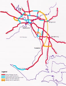
A 1994 map of Melbourne’s road network with missing links indicated and no suggestion of a “Corridor B” poposal. From a Vicroads publication “Linking Melbourne”, February, 1994.

In other words, Banyule Council supports the concept of Corridor B equally as much as Corridor C as a viable alternative to bad, bad Corridor A! The scenic railway of the Corridor D (Kangaroo Ground) proposal has already been ruled out by most pundits which leaves Corridor B looking increasingly like an unlikely NEL compromise between Corridors A and C, routes which have been strongly opposed by Banyule and Nillumbik respectively. Let’s face it, when it comes to opposing Corridor B through Yallambie and Lower Plenty, we are on our own as the letter from the Mayor of Banyule makes quite clear.

Lower Plenty Road in 1914, south west of the Rosanna Rd intersection. (Source: Picture Victoria, Heidelberg Historical Society image).

At a meeting at the old Heidelberg Town Hall last month, during a long discourse about the limitations of Corridor A, the Mayor made the fair point that something needs to be done because Rosanna Road, the current de facto orbital link, was well, “full”. Yes, it’s full but it’s not just Rosanna Rd that’s full. The reality is that it’s the planet that is full and we have only been adding to the problem. I might be in a minority but I’m sure I’m not alone in not wanting any of these road proposals built. The ongoing need to build more freeways is a symptom of the problem but not the problem in itself.  With desalination plants needed to provide our society with drinking water and a conurbation of towns and cities fast consuming our arable land surfaces, mankind has not been kind to the planet it calls home. When those covered wagons wheeled out across the Prairie in the 19th century it seemed that there were no limits to the horizon but the reality today is so much more uncertain.

Marco Amati from the RMIT Centre for Urban Research was quoted in a story in “Domain” last week saying that the greening efforts of local governments had not been as effective as hoped and that with a major decline in canopy coverage, “As they lose vegetation, urban areas start to act like heat sponges.”

To digress along this line, consider for a moment the case of a remote Pacific island, Ocean (or Banaba) Island, an elevated speck of rock within the island nation of Kiribati, (pronounced “Kiribus”). Just 10km in circumference, Ocean Island had been home to a British phosphate mining industry for the first ¾ of the 20th century leaving its hinterland a scarred moonscape when I saw it during a prolonged visit some years ago, denuded of both vegetation and the tribal society that once called the island home.

Early 20th century photograph of Banabans in traditional dress on Ocean (Banaba) Island. (Source: A St. C Compton collection)

The shameful plight of the Banabans is a long and compelling story, too long for these pages, but suffice to say that the exiled locals now live mostly on a completely different island in the Fiji group. Meanwhile the ecological fate of their homeland is to my mind the story of our planet in a microcosm. The Island is infamous for its droughts and so much vegetation was eventually removed from it that when rain clouds approached the island, it was recorded that the clouds would separate around the pulsating heat emanating from the denuded rock surfaces to join up again on the other side, dropping all the while their much needed rain into the ocean. This claim might seem far-fetched, but the mining industry on the island had a desalination plant operating on the island long before Victoria ever needed one.

I’m not pretending that there’s an answer. You wanna planet of 7½ billion people and counting, you need cities to put ’em in and roads to get them around.  That nutcase in North Korea reckons he has the answer to having too many people on the planet, but his answer isn’t really an answer and would destroy the planet itself.

The English animator Steve Cutts summed it up poignantly in 2012 with his environmentalist message, “Man”. The prospect of a flying saucer arriving to mete out primary justice to mankind might raise a Golgafrinchan style smile right now, but without flying saucers to make good our escape, a smile may be the only thing we have left one day on this “Pale Blue Dot”.

You oughta be in pictures

Did you ever spend your time at school, when you should have been paying attention, drawing pictures of little stick men in the margins of your geography book designed to spring to life when you flicked back the edges of the pages? The equivalent today I suspect of surreptitiously watching episodes of Family Guy on an iPhone under the edges of a school table.

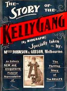
The art of the moving picture was widely practised in Australia from the earliest days of cinema. In the early 20th century, Australian film in some respects rivalled the embryonic industry on the West Coast of the United States, very apt for a newly Federated Australia. In the century before, Australians had thought of themselves as Englishmen living abroad and spoke of going “home” to Great Britain. By Federation we were thinking of ourselves as first and foremost true blue “Aussies” but with our own special place within an Empire on which the sun never set. Historical drama with a local content was popular in Australia from the outset and the world’s first narrative feature film is believed to have been the 1906 “The Story of the Kelly Gang” which, pertinent to this story, was filmed at locations around the Heidelberg district, many of which would have been familiar to the residents of Yallambie at that time.

Charterisville in Ivanhoe, built by David Charteris McArthur, c1845.

These included the property Charterisville, leased at that time as a dairy farm by the family of the producer’s wife and located today in Burke Rd North, Ivanhoe; the Rosanna Station railway siding, where scenes of Kelly’s “last stand” at Glenrowan were filmed; and at nearby locations in both Eltham and Greensborough, where additional scenes were made.

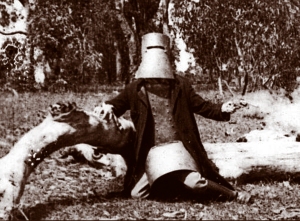
Kelly's last stand from the 1906 film, "The Story of the Kelly Gang".
Kelly’s last stand from the 1906 film, “The Story of the Kelly Gang”.

The film was a great success and made a fortune for its backers, sparking the outlaw as a subject of film genre and popular culture with the iron clad bushranger being subsequently portrayed on screen by a diverse range of alleged actors from the Australian Rules footballer Bob Chitty to Mick Jagger of rock and roll fame. In the words of the real Kelly as he faced the scaffold in 1880, “Such is life.”

The precise story of early film making in Australia is probably lost to history like the cellulose nitrate film stock on which it was recorded. It is known that Kooringarama Films shot a silent short feature in and around Eltham in 1928 called “Borrowed Plumes”. Kooringarama Films was an amateur company and followed up the following year with four reel, one hour feature, also shot in Eltham, called “As Ye Sow” which was shown to audiences in local halls around Melbourne with an incidental musical accompaniment delivered on a hand cranked gramophone.

Still from the short feature, "Borrowed Plumes" filmed in Eltham in 1928.
Still from the short feature, “Borrowed Plumes” filmed in Eltham in 1928.

Three decades later Tim Burstall, an Eltham resident whose wife taught French at Eltham High School, made his first short feature “The Prize”. It was shot using an old clockwork camera of the type used in battle in the first world war mounted on a 1930s tripod from an Antarctic expedition. It portrayed a boy wandering through the bush in search of a lost goat and most of the locations used were in the vicinity of Eltham. The film won a bronze medal at the Venice Film Festival of 1960 with Burstall later going on to play a principle and “Purple” part in the reinvention of the Australian film industry in the 1970s.

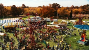
Screen still of Heidelberg Park restyled as Somerset County Fairgrounds, from 2006 film, Charlotte's Web, (Nickelodeon Movies).
Screen still of Heidelberg Park restyled as Somerset County Fairgrounds, from 2006 film, Charlotte’s Web, (Nickelodeon Movies).

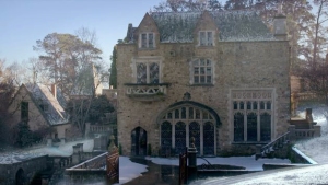
Locations in and around the Heidelberg district continue to be used today in both film and television. The 2006 Nickelodeon production “Charlotte’s Web”, used locations around Heidelberg Park which was transformed for the purpose of the screen to resemble a fair ground in the mid-west of the United States. Similarly, the final episode of Series II of the “Miss Fisher’s Murder Mysteries” saw the artist colony “Montsalvat” in Eltham portrayed as a property in the so called “Australian Alps”. In the event and after the addition of a few dodgy special effects, that hang out looked oddly enough more like a castle hideaway in the Swiss Alps. A sort of Monsalvat on the Matterhorn.

Montsalvat in Eltham as seen in Episode 13 of Series 2 of the Miss Fisher Murder Mysteries, 2013, (Every Cloud Productions).

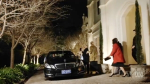
The process is not without the potential for problems all the same with the owners of a home featured in the 2013 movie “The Conjuring” reportedly suing Warner Bros for an unspecified amount over trespassers coming up to their home as a result of the film’s popularity.

Screen still of Banyule Homestead from Episode 3 of The Ex-PM, (CJZ, ABC TV).

Most recently in Heidelberg, Banyule Homestead has been seen in great detail on the small screen in Shaun Micallef’s amusing “The Ex-PM”, (which also features scenes shot in the surrounding area including one from the opening episode shot on Greensborough Rd, Watsonia), while Napier Waller’s Fairy Hills property continues to be portrayed as the Ballarat home and surgery of the titular character in the returning series, “The Doctor Blake Mysteries”. As ownership of Banyule Homestead changed hands a few months ago and the Waller home enjoys a peculiar rates agreement with local Council, perhaps the publicity isn’t seen as a problem at those properties.

Everyone with a camcorder or even an iPhone can be a film maker of sorts these days although, previously, home movies were limited to the lens sharpness and the sometime dubious technical skills of those fortunate enough to own 16mm or 8mm movie cameras. Yallambie itself was captured on film in a fascinating and previously discussed flick of this sort in the late 1950s, before the subdivision of the estate and while it was still operating as a farm. The 20 minutes of silent, 16mm colour moving picture was shot by Peter Basset-Smith, a professional film maker and friend of the of the last descendants of Thomas Wragge to live at Yallambie.

Bassett-Smith’s film stands alone today as a fascinating tribute to that now vanished era. A few years ago a former singing chum of my wife contacted us out of the blue with news that she had embarked on a career herself in film making. In fact, she was in the process of co-producing a low budget horror film with her son for which development was well underway. She too had been to Montsalvat to enquire about using that property as a location but was disappointed to learn that the fee asked by the trustees was almost more than her whole production budget.

“Hmmm, a horror story you say? I know just the place. It’s not quite Montsalvat or the Matterhorn but will suit your needs.”

So it was that the production crew came to Yallambie as our guests and spent a couple of days on location in the our garden shooting scenes for the movie “Killervision”, (21 Black Entertainment, 2014). It was great fun to be an observer of the process and I soon perceived the possibilities of the creative, almost addictive buzz that is a part of the film making business.

Character brandishing a piece of 4 by 2 in the garden at Yallambie, (Killervision film still).

Some of the action filmed at Yallambie required one of the actors to run through the garden screaming at the top of his lungs brandishing an ugly piece of 4 by 2, (in reality a lump of balsa wood). I wondered, probably too late, what the neighbours might think about this blood curdling racket and was rather perturbed at one point to hear police sirens in the distance. When those sirens came nearer and were obviously proceeding down Yallambie Rd I started to feel really concerned. I was standing next to a car at the time belonging to a member of the film crew and could see a set of (prosthetic) severed fingers oozing fake blood which had been left on the dash board. ‘How would I explain this to the cops?’ Thankfully it was a false alarm as the sirens proceeded further afield. Maybe the hamburgers from Maccas on Lower Plenty Rd were in danger of getting cold on their way back to the station.

On the soccer ground in Yallambie Park, (Killervision film still).

The movie, “Killervision” was eventually finished and sold to an international film distributor. The credit cards used were balanced and the actors were paid. We received a complimentary DVD copy of the movie and it was with amusement that I saw while viewing it later that the exterior of the Homestead appears very briefly and out of focus on screen where it is described as being a facility for the mentally disturbed.

Fictitious university prospectus featuring Homestead, (Killervision film still).

In a world being rapidly changed by the advent of new technologies, the art of the moving picture is no exception. Local cinemas were once to be found in many suburban venues around Melbourne but the multiplex venue has largely seen their demise. The Were Street, or Rotex Cinema in Montmorency with its purple curtains was one that I remember as a lad but there were earlier venues in both Burgundy St, Heidelberg and Upper Heidelberg Rd, Ivanhoe. A changing industry almost saw the death of the Australian film industry and certainly the closure of most independent suburban cinemas but a modern Renaissance, supported in large measure by Federal Government tax breaks, has seen the trend reversed. Hugo Weaving who has appeared in many Australian films of this later era as well as several international blockbusters was quoted from ABC television last week, saying that:

“This is a golden era of film-making in this country, we just don’t know that. I’ve been saying that for ages. I think our films are getting better and better, we [Australians] are just not going to see them.” (One Plus One, ABC TV)

Ol’ Elrond himself believes that the problem is basically selling the idea of Australia to a local market:

“We have an industry which is so slanted towards American films that it’s very, very hard for Australian films to get a look in.”

Ol' Elrond himself.
Ol’ Elrond himself.

It’s known as the “cultural cringe” and the problem is not a new one. The film makers involved in the “The Story of the Kelly Gang” in 1906 only realized the contribution to cinematic history they had made long after the fact, when it seems several of them jockeyed for credit of the initial concept.

On release of the 1959 Hollywood movie “On The Beach”, an American film that was shot in and around Melbourne about a world destroyed by nuclear holocaust, Ava Gardner is supposed to have said that Melbourne was “the perfect place to make a film about the end of the world.”

Gregory Peck and Ava Gardner on location for the 1959 film "On the Beach", (Stanley Kramer Productions).
Gregory Peck and Ava Gardner filming the end of the world in Melbourne.

The story is almost certainly apocryphal. The quote appears to have been written by a Sydney journalist struggling to make deadline but it does illustrate all the same a very real and enduring inferiority complex that has always been a part of our way of looking at ourselves in this country. Meanwhile the Australian film industry continues to acquit itself on the global stage and not just with the export of Australian acting talent overseas. It has been said that to be born an Australian is to win the prize in the lottery of life. They call this the Lucky Country. It’s a pity we haven’t quite noticed it.

The_Story_of_the_Kelly_Gang_Poster