
The Australian writer and historian Don Watson once posed the tempting question, “What will history make of us should there be any historians left to write it?”
The news last week that the State Government had decided on Corridor A as the chosen route for the North East Link freeway leaves a devastating conflict of emotions for nearby communities. There is the feeling of relief that the alternative B, C and D roads will now, at least not for the time being, be built, but this is coupled with a general feeling of dismay at the destruction Corridor A is likely to wreak.
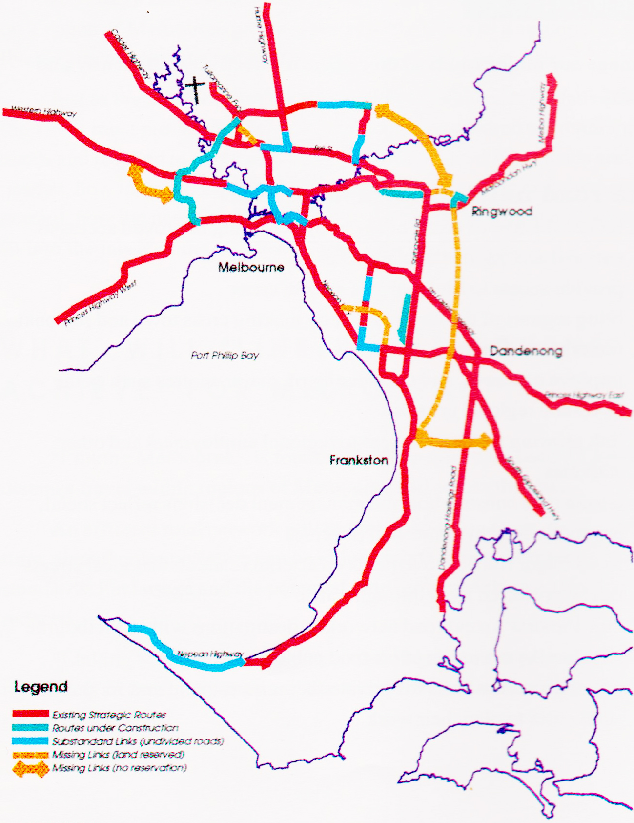
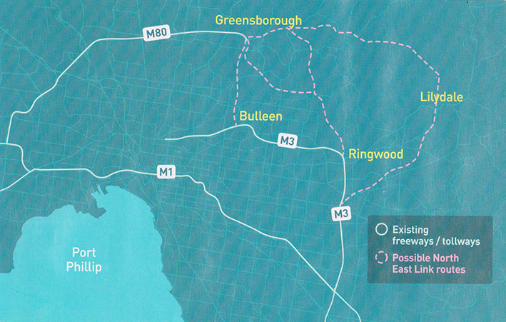
Corridor A when built will largely cut an underground path under Viewbank and Rosanna, with road interchanges located at Bulleen and Lower Plenty Roads, but it will be the surface road parallel with Greensborough Road along the Western boundary of Yallambie with Macleod and in Watsonia in the north, together with the associated road interchanges at either end that will have the most obvious visual impact. At least 75 homes are expected be lost to the plan and it’s pretty clear to anyone familiar with the local area just where these are likely to be.
The government spent $100 million to write a study of their four, so called alternative routes which included the utter surprise of their Corridor B proposal through the heart of Yallambie, but in the end the extra corridors were a smoke screen, an attempt to muddy the water surrounding a proposal to build Corridor A which, because it was expected to be cheaper, was always going to be the favoured option.
Corridor A has been talked about ever since something like it was first proposed in the 1969 Melbourne Transportation Plan. It wasn’t built because enough people could see back then that it was a bad idea. So what has changed? A decade ago the proposal was still on the table and costed at $6 billion, but last week’s announcement rings in now at over $16 billion. The real question then is, just how much is this thing going to cost eventually, and I don’t just mean in dollar terms.
Perhaps the NELA aren’t aware of some of the worry and the sleepless nights that they have given Yallambie and Lower Plenty residents since the first suggestion of Corridor B was disclosed in August. Perhaps they don’t care. This sort of cavalier attitude is nothing new, as the recent to-ing and fro-ing over the abandoned East West Link proposal is evidence, but fifty years ago the following story illustrates perhaps just how strongly passions can run on such matters.
In the mid 1960s, at a time before the first spade had been turned on Melbourne’s freeway network, a plan was developed by Doncaster and Templestowe City Council in conjunction with the Country Roads Board to widen Templestowe Rd in Templestowe at the Thompsons Road intersection. The plan when first discussed involved realigning Templestowe Rd at its closest approach to the Yarra River with Parker St in the east, through the heart of the Templestowe township.
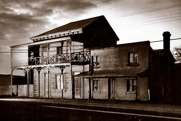
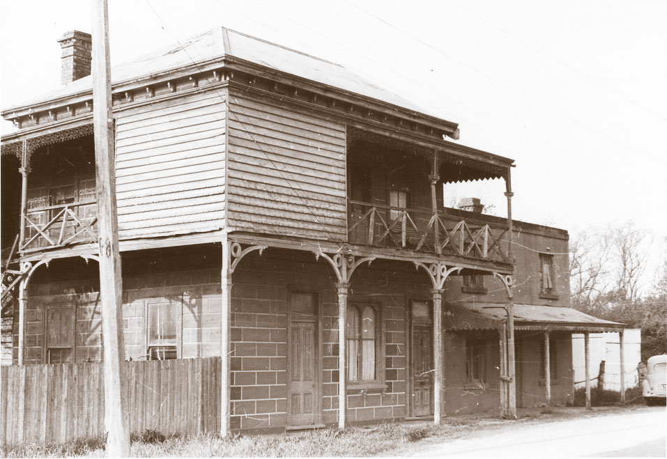
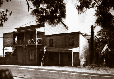
But there was a problem. Finn’s Upper Yarra Hotel, a local landmark of some renown, stood right in the path of the new road.

The Upper Yarra Hotel was a much loved building. James Finn had opened his hotel as a beer shop on the Templestowe corner in 1866, near what is now a vanished river crossing, and over the years various additions had been made to it which had combined to create a strange amalgamation of architectural styles. The idiosyncratic compact construction of the original building seemed to stand at odds with the later, two-storey block fronted section but somehow they combined almost by accident to form a building of considerable rambling charm.
The Upper Yarra was delicenced in the early 1920s but as it aged and became more dilapidated the rustic appeal of its setting became a favoured subject for local artists. The various parts of the hotel itself were painted a rusty red colour in an attempt to bring unity to its conflicting parts and as the paint peeled the overpainted words “Finn’s Upper Yarra Hotel” stood out like a ghostly commentary as to the building’s former life, an old world garden and a cobbled stable yard behind the hotel completing the overall effect of a genteel rural decay.
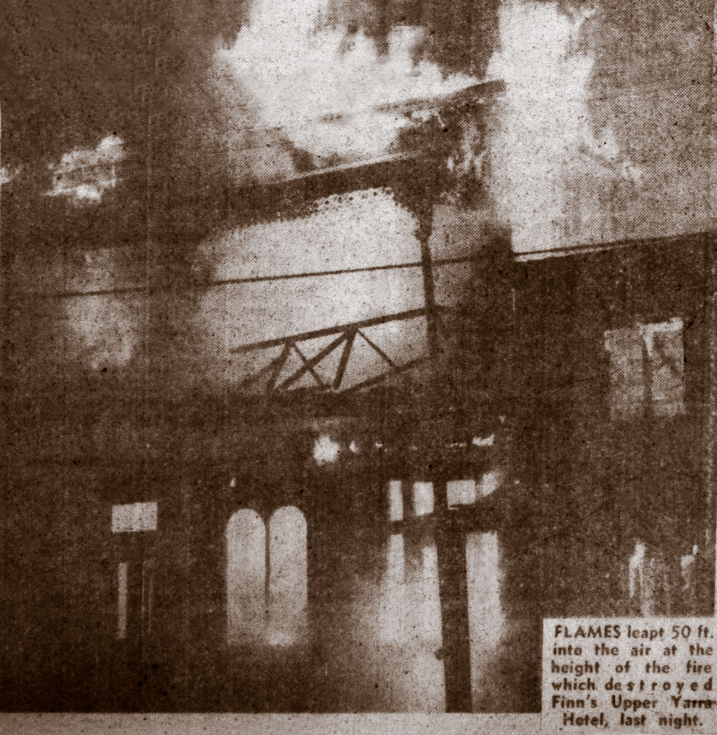
The grown up grandchildren of James Finn were still living somewhat reclusive lives at the old hotel in the mid 1960s when the Council came a knockin’. Doncaster and Templestowe City Council had purchased the land on which the Upper Yarra Hotel stood from the executors of the estate of the son of James Finn and the Council were trying to force his grandchildren from the building which the surviving generation still occupied. The Council met with some militant but probably understandable opposition from the residents who objected to being moved away from the building their family had occupied for over a hundred years. One contemporary newspaper report described how a party of journalists was chased away from the hotel environs one evening in 1967 by an aging Finn brother wielding a big stick, smashing up a photographer’s car in the process in the mistaken belief that the newspaper party were officers from the Housing Commission come to enforce an eviction order.
In the end the Council got their way of course and the Finns removed themselves voluntarily from the building on the 28th May, 1967. On the night of departure however a mysterious fire broke out in the old weatherboarded building, quickly reducing it to a pile of cinder and rubble in spite of the best efforts of the Country Fire Authority to combat the blaze.
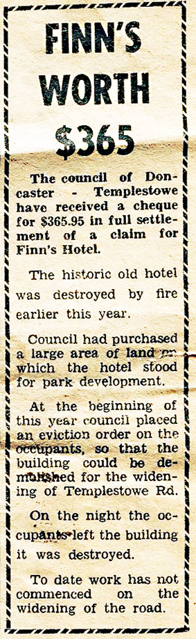
It was a tragic loss to history for the area. The Council had been discussing the possibility of moving the hotel out of the path of the imagined road realignment in a manner that they would later employ to save another historic Doncaster building, Schramm’s Cottage, in the 1970s. The fire put an end to any further discussion, Ad infinitim.
Eventually the Council accepted a cheque of $365.95 as compensation for the loss of the building, but the money was not really the point. The final irony in the telling of this story is that when the realignment of Templestowe Rd eventually took place, a decision was made to straighten the route to meet with Foote St parallel to Parker Street, which is the situation as it exists today. If Finn’s Hotel had been standing and not by then a pile of ashes, it would have been in the clear.
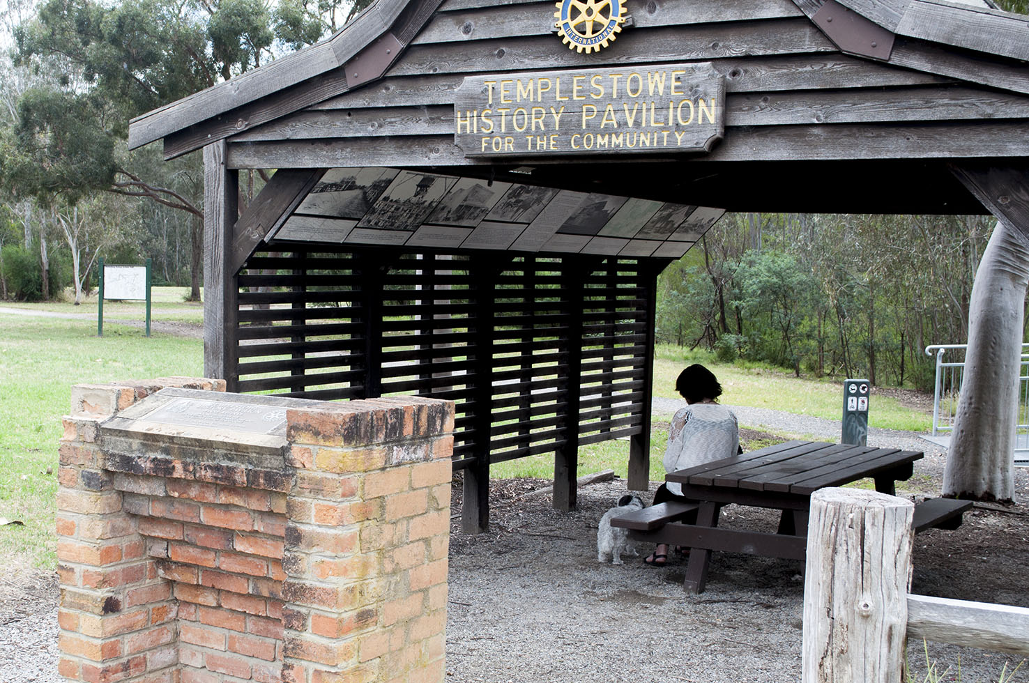
Today a so called “History Pavilion” on Templestowe Rd, Templestowe marks the site of the former Upper Yarra Hotel, with photographs plastered around the interior detailing the (now mostly vanished) history of the area. It is a strangely sad, not often visited tribute.
So how does this story affect the reality of the Corridor A proposal for North East Link? The above tale is an example that road plans are not set in stone until such time as they are actually set in concrete, whether they be tunnels or tarmac and you don’t have to burn down a building to find this out. Melbourne University transport lecturer John Stone was quoted in a newspaper story about State Government transport spin doctoring in The Age last month saying that, “Communities are presented with Maggie Thatcher’s old line – ‘There is no alternative’ – and often there is. But under the current system, the community can only be heard if they can create enough political will to be heard.”
Opponents of North East Link Corridor A have called a public meeting today on a rainy afternoon at Koonung Creek Reserve, Balwyn North and the AGM of the Friends of Banyule is scheduled for Thursday night at the old Shire offices in Beverley Rd, Heidelberg where there will be no prizes offered for guessing what will be the main item on the agenda that night. The opposition to Corridor A in these neighbourhoods is understandable but by any reckoning, the real opposition to the route should be coming from groups here in the north. Corridor A will be a surface road when it passes through Greensborough, Watsonia and Yallambie/Macleod and two of the three major new road interchanges will be situated here. The lack of opposition here however is the result of the earlier sleight of hand exercise conducted by NELA when they divided community opposition with the suggested alternative Corridors, B, C and D. That’s what the State Government got for spending a $100 million to investigate the alternative corridors, although they said at the time the money was to be used to cover the cost of “geotechnical investigations, design, environmental and social studies”. The cold, hard reality is that Corridor A will have a devastating effect on the City of Banyule, dividing the municipality in two in a north south direction along Greensborough Rd while doing little to relieve the very real traffic problems in the area. Vale to the City of Banyule.
Like the Finns at the old Upper Yarra Hotel, the lives knocked about by these road proposals are real people with real homes, each with their own story to tell and each with a sense of community and belonging. $16 billion and counting sounds to me like an awful lot of money to be spending on building a road, a road that won’t even do what it is intended to do, that is complete the missing link in Melbourne’s Ring Road system. Look at a map of the proposed route of Corridor A and you will see that the Corridor A route does not contribute to a ring at all but is a dent in the road plan, driving ring bound traffic back towards the city before asking it to fan out again in an easterly direction.
So when is a ring not a ring? When it is a link in the eyes of the North East Link Authority. The building of Corridor A will not remove the need to build a completed ring through Eltham in years to come. The thing is, by then the State will be so bankrupt that this will never happen, no matter what needs might then be presented. By that time too with the advent of AVs (autonomous vehicles), cars as we know them now might be a thing of the past, which poses some interesting speculation in answer to Don Watson’s original conundrum.
